10
Loading video...

By Joe Edwards
Reporter
0
Share
Newsweek is a Trust Project member
See more of our trusted coverage when you search.Prefer Newsweek on Googleto see more of our trusted coverage when you search.
Hurricane Erin would have the potential to trigger 100-foot waves as it moves across the waters of the Atlantic Ocean, according to forecasters.
Why It Matters
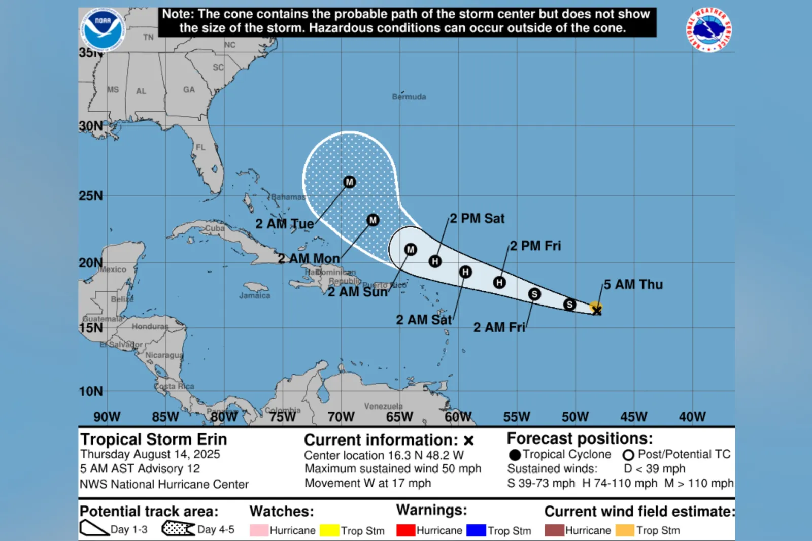
Currently classified as a tropical storm, Erin could develop into the first major hurricane of the 2025 season, experts say.
Read More on News
It is the fifth named system of the Atlantic hurricane season so far, following Andrea, Barry, Chantal and Dexter—none of which developed into hurricanes.
...
What To Know
Jean-Raymond Bidlot, senior scientist in ocean modeling at the European Centre for Medium-Range Weather Forecasts (ECMWF) told Newsweek that Erin is forecast to strengthen over the next week as it heads toward the U.S. East Coast, reaching peak intensity offshore from Cape Hatteras.
Remaining at sea, it could produce large waves through "dynamic fetch," where wind-driven waves match the storm's speed and gain extra energy. This effect can generate waves larger than wind strength alone would predict, primarily to the right of the storm's low-pressure center, Bidlot explained.
"The latest forecast does indeed indicate that the largest significant wave height could reach values in excess of 50 feet with an associated most likely largest wave of more than 100 feet," Bidlot said.
These will be large, long waves—hundreds of meters in length—not a single wall of water, the scientist said, adding that they are typical for such intense storms and should not be mistaken for rogue waves.
AccuWeather lead hurricane expert Alex DaSilva told Newsweek that the waves could cause "major shipping disruptions as well as change itineraries for cruise ships."
"The strong winds from the storm creates these waves and they propagate out from the storm. Depending on how close the storm gets to the U.S., there can even be beach erosion in some areas," DaSilva said.
What People Are Saying
Senior scientist in ocean modeling at the European Centre for Medium-Range Weather Forecasts (ECMWF) Jean-Raymond Bidlot told Newsweek: "Hurricanes are known for their very powerful winds, usually confined to an area around the storm center, but as indicated, waves tend to radiate away from the storms, propagating towards coastal areas even though the brunt of the storm might still be miles away from the coast.
"These storm-driven waves might not be the largest but will still be significant and have the potential to create very hazardous conditions when reaching the shore leading to intense surf conditions and dangerous rip currents well before the arrival of the storm clouds and rain associated with the hurricane."
AccuWeather lead hurricane expert Alex DaSilva told Newsweek: "While 100 feet can't be ruled out, I think they would only be possible if the storm become a Category 4 or 5 storm.
"I think waves near the center of 50-75 feet are much more realistic (assuming a Category 3 storm)."
What Happens Next
Forecasts are sometimes subject to change.
According to the National Hurricane Center, Erin is forecast to become a hurricane by Friday.
View 0 Comments
Submit Correction
View Editorial & AI Guidelines