...

By Jess Thomson
Science Reporter
0
Share
Newsweek is a Trust Project member
See more of our trusted coverage when you search.Prefer Newsweek on Googleto see more of our trusted coverage when you search.
Temperatures across the U.S. have plunged this week thanks to a blast of Arctic air from the north, with much of the country facing freezing cold weather and heavy snow.
Nearly 100 million citizens were under a wind chill advisory as of January 14, which lasted several days as the Arctic chill gripped the country.
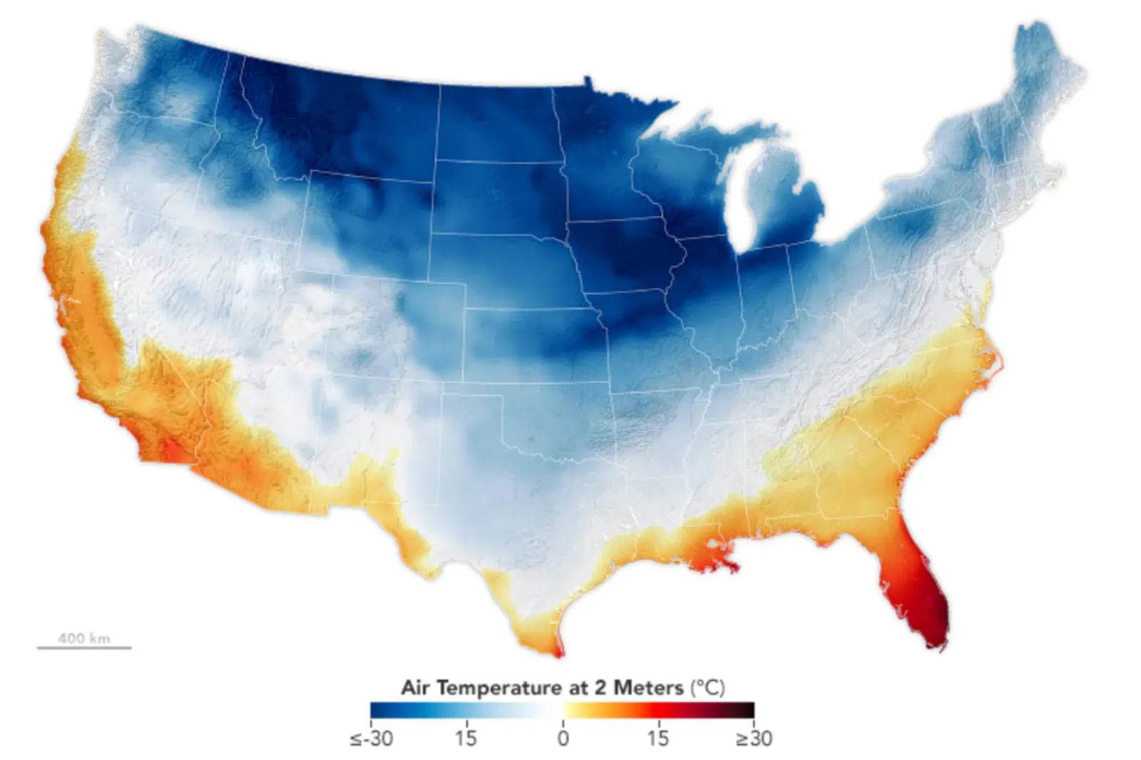
A map made using data gathered by NASA satellites and modeled using the Goddard Earth Observing System (GEOS) showed temperatures around the country on January 15, at a height of 6.5 feet above the ground.
Read More
Rhinos at Risk as Temperatures Set to Become Deadly4 min read

Majority of US Cities Are Experiencing the ‘Urban Heat Island’ Effect4 min read

NASA Releases Image of US Deadly Winter Storm From Space5 min read

It reveals that huge swaths of the Great Plains states and the Midwest saw temperatures lower than 5 degrees Fahrenheit, with some regions dropping as low as -22 degrees. Only Florida, Texas and parts of the Southeast and Southwestern states were above 32 degrees Fahrenheit.
...
On January 13, Billings, Montana, saw a record low since 1999 at -30 degrees Fahrenheit, while parts of Montana and the Dakotas experienced wind chill temperature—how cold the air feels on the skin—lows of a staggering -60 degrees. The Great Lakes were so cold that Lake Michigan was covered in fog.
Even Texas saw record lows, with Houston experiencing temperatures of 19 degrees on January 16, an all-time low for that date. Snow fell across New York state, with 2 feet covering the western regions on January 13 and 14. The Pacific Northwest saw the frigid temperatures combine with an atmospheric river hitting from the Pacific, leading to heavy snow and freezing rain.
"Sub-zero wind chills will continue to affect much of the Rockies, Great Plains, and Midwest into Tuesday, with wind chills below minus 30 extending as far south the central Plains and mid Mississippi Valley," the NWS Weather Prediction Center said in an update on Monday. "These wind chills could cause frostbite on exposed skin in a few minutes and hypothermia shortly thereafter. Avoid outdoor activities if possible. If you must be outside, wear appropriate clothing, dress in layers, and cover exposed skin. Keep pets indoors. Have a cold survival kit if you must travel."
Even more cold weather is due to descend across the country throughout the rest of the week.
"Temperatures are expected to moderate midweek. However, a new surge of colder air will drop south over the northern Plains and Midwest, reaching the Deep South by the end of the week," the NWS said in the Monday update.
Extreme winter temperatures and storms are normal at this time of year, but they may become more intense amid the effects of climate change.
"Climate change will likely exacerbate these types of storm scenarios," Jana Houser, an associate professor of meteorology at Ohio State University, told Newsweek. "An increasingly warm climate will have a particularly strong effect on the ocean temperatures. As ocean temperatures warm over the summer months, this heat is retained much longer than heat in the air is, so moving into winter months, the ocean temperatures will be higher now and in the future than they were 50 years ago."
"The incredible cold in Canada and other Polar regions is still likely to occur even in warming climate scenarios, because there is simply no incoming light. This creates a scenario where the temperature contrast between the warm ocean temperatures and the cold, polar and arctic air masses is actually going to increase in the future. The increase in the contrast will provide even more energy to developing low pressure systems, causing them to be more intense than they might otherwise have been in a non-climate change scenario."
Do you have a tip on a science story that Newsweek should be covering? Do you have a question about cold weather? Let us know via science@newsweek.com.
View 0 Comments
Submit Correction
View Editorial & AI Guidelines