10
Loading video...


By Michael D. Carroll and Rachel Dobkin
0
Share
Newsweek is a Trust Project member
See more of our trusted coverage when you search.Prefer Newsweek on Googleto see more of our trusted coverage when you search.
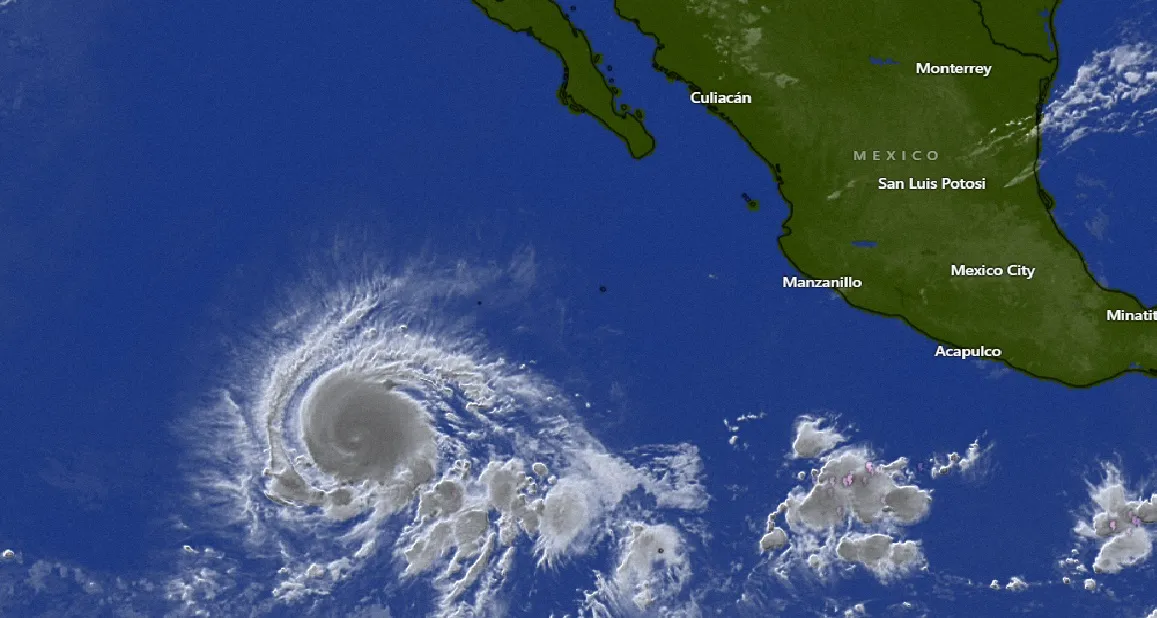
Hurricane Kristy has rapidly intensified into a Category 4 storm in the Pacific Ocean and is expected to strengthen further as it heads westward, according to the National Hurricane Center (NHC).
The hurricane is currently located around 650 miles southwest of Mexico's Baja California peninsula, moving west at 20 mph with maximum sustained winds of over 100 mph, the center reports.
...
Read More on News
Rapid intensification occurs when a tropical storm strengthens dramatically in little time. After forming as a tropical storm off Mexico's southern Pacific coast on Monday, Kristy strengthened into a Category 1 hurricane on Tuesday before turning into a Category 3. On Wednesday afternoon, forecasters said Kristy had strengthened into a Category 4.
More From Newsweek Vault: 5 Steps to Build an Emergency Fund Today
A Category 4 hurricane has sustained winds from 130-156 mph.
Hurricane Kristy's Path
Forecasters predict it will pose a potential threat to surfers and others in the water as the hurricane continues its path westward.
More From Newsweek Vault: What Is an Emergency Fund?
"Kristy is moving toward the west near 20 mph (31 km/h), and this general motion is expected to continue through Thursday," the NHC said in its report. "A gradual turn toward the west-northwest and northwest is expected on Friday and into the weekend."
Kristy is expected to strengthen and then weaken before this week is over.
"Additional steady to rapid strengthening is expected during the next day or so," the NHC said. "Gradual weakening is forecast to begin on Friday."
More From Newsweek Vault: Online Banks vs. Traditional Banks: Learn the Differences
Potential Hazards
The only hazard "affecting land" that the center warned about was surf and rip current conditions. Swells created by Kristy will affect parts of the west coast of the Baja California peninsula later in the week.
"These swells are likely to cause life-threatening surf and rip current conditions," the center said.
There are no coastal watches or warnings currently in effect.
Pacific Hurricane Season
Hurricane Kristy is the 11th named storm of the eastern Pacific hurricane season.
The season differs from the Atlantic hurricane season, which runs from June 1 to November 30 and includes the Atlantic Ocean, Caribbean Sea and Gulf of Mexico. The eastern Pacific hurricane season runs slightly longer, beginning two weeks earlier on May 15 and running through November 30.
"The eastern Pacific basin extends from Mexico and Central America westward to 140°W. Based on a 30-year climate period from 1991 to 2020, an average eastern Pacific hurricane season has 15 named storms, 8 hurricanes, and 4 major hurricanes," the NHC said in a webpage. "The first named storm typically forms in early to mid-June, the first hurricane tends to form in late June, and the first major hurricane forms in mid-July."
This year, the first hurricane in the eastern Pacific was Carlotta, which formed in early August. It was preceded by two tropical storms.
This article includes reporting from The Associated Press
Update 10/23/24 3:02 p.m. ET: This article has been updated with additional information.
Update 10/23/24 5:00 p.m. ET: This article has been updated with additional information.
View 0 Comments
Submit Correction
View Editorial & AI Guidelines