Climate Prediction Center

By Joe Edwards
Reporter
0
Share
Newsweek is a Trust Project member
See more of our trusted coverage when you search.Prefer Newsweek on Googleto see more of our trusted coverage when you search.
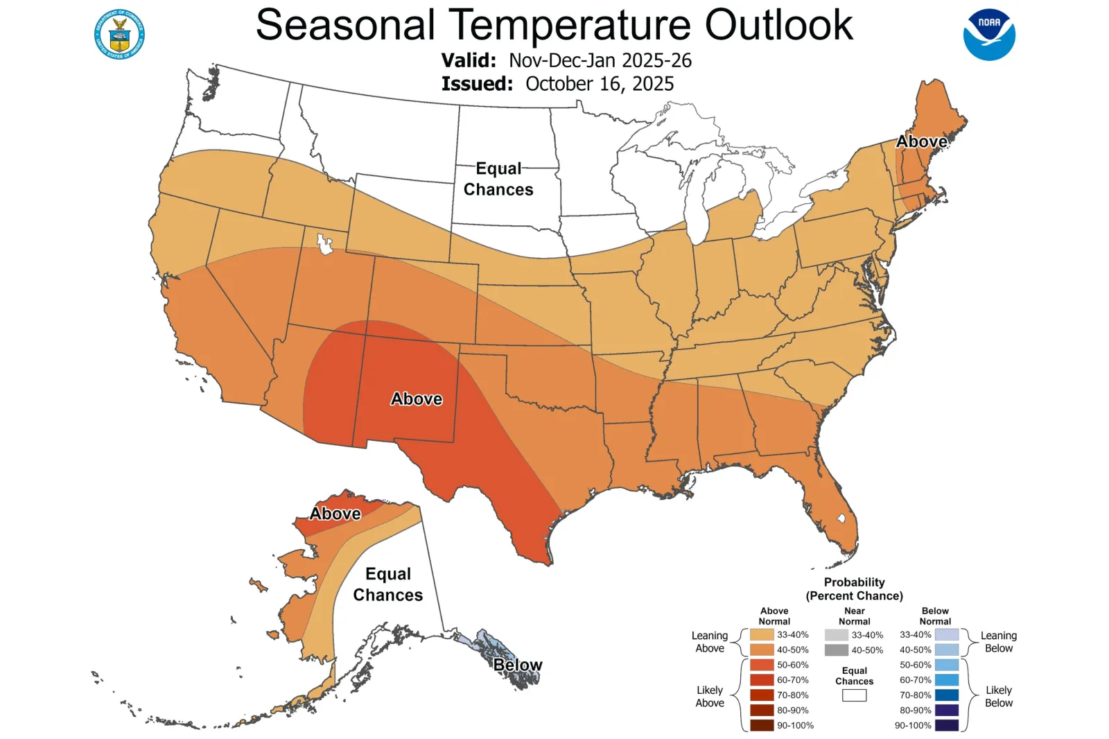
Forecast maps issued by the Climate Prediction Center (CPC) show what weather conditions the U.S. can expect over the November to January period.
Why It Matters
The CPC previously announced that La Niña conditions had been detected and were expected to continue from December 2025 to February 2026.
Read More on News
Although La Niña was expected to remain weak, the NWS said it could still influence the upcoming winter season.
What To Know
According to the CPC’s temperature outlook for the November to January window, the areas most favored to see above-average values include parts of southern, central and western Texas, the majority of New Mexico, and roughly the eastern half of Arizona. Southeastern Utah and parts of southwestern Colorado were also included in this category.
...
The majority of the U.S. may also see above-average temperatures, according to the outlook, although states with equal chances of above- or below-normal temperatures include:
- Wisconsin
- Minnesota
- North Dakota
- South Dakota
- Montana
- Washington
In terms of precipitation, Washington, Oregon and parts of Idaho and Montana are most likely to see above-average levels from November to January, according to the map.
Conversely, states in the south, southwest, and southeast are forecast to see drier-than-normal conditions this winter.

...
What People Are Saying
Jon Gottschalck, CPC Operational Prediction Branch chief, told Newsweek in October: “Although [La Niña] is currently favored to be in the weak category we still factored it into our temperature and precipitation outlooks for the [December to February] outlook. Typically as one might understand, the likelihood of La Niña specific impacts is somewhat less than say for a strong event. Nevertheless, weak events in the past have resulted in substantial temperature and precipitation impacts during certain events/years.
“With respect to the 2025-2026 winter outlook, typical La Niña impacts contributed to the forecast of favored below-normal temperatures for extreme southeast Alaska, the Pacific Northwest eastward to the northern Rockies, northern Plains and western Great Lakes. The same can be said for the favored above-normal temperatures from extreme southern areas of the Southwest and southern Texas and for the Southeast.
“For precipitation, La Niña contributed to the enhanced likelihood of above-normal precipitation for the west coast of Alaska, the Pacific Northwest, the northern Rockies, northern Plains, the Ohio Valley and areas in the western Great Lakes. Similarly for the enhanced odds of below-normal precipitation from the Southwest, southern Texas and especially the Southeast coastal region.”
What Happens Next
Meteorological winter begins on December 1 and lasts through the end of February. Local forecast updates are issued by regional NWS branches on the agency’s website and social media channels.
View 0 Comments
Submit Correction
View Editorial & AI Guidelines