...

By Anna Skinner
Associate News Editor
0
Share
Newsweek is a Trust Project member
See more of our trusted coverage when you search.Prefer Newsweek on Googleto see more of our trusted coverage when you search.
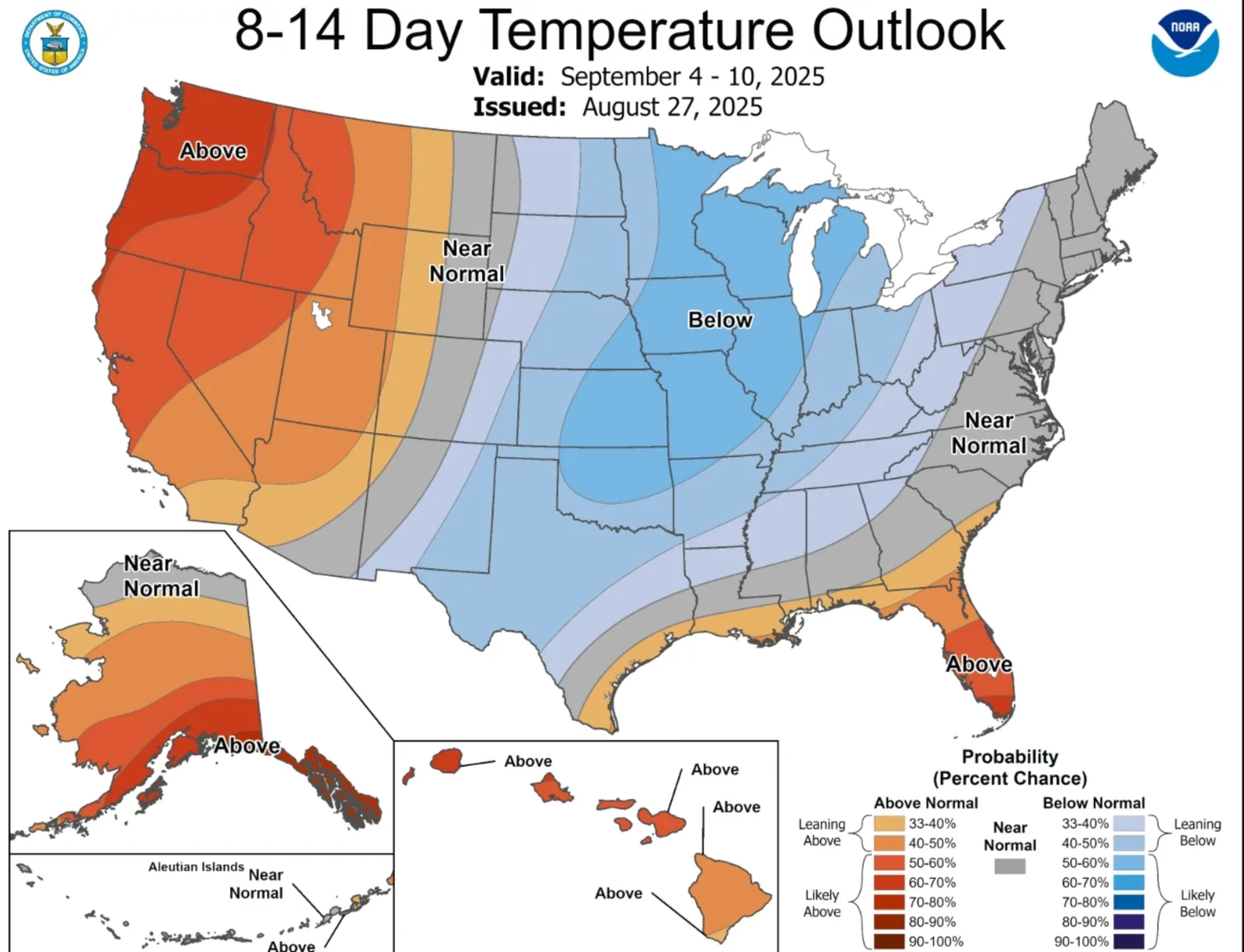
Millions of Americans can expect below-average temperatures to persist across much of the United States next week, according to a temperature outlook map from the National Weather Service (NWS) Climate Prediction Center, with the steepest variations from average expected in the Central U.S.
Why It Matters
The end of summer has brought contrasting weather across the U.S. A cold front ushered in below-average temperatures in many U.S. states this week, dropping temperatures as far as 30 degrees below average for parts of the Central and Southern Plains and sparking frost advisories in the Upper Midwest.
Read More on U.S.
Meanwhile, abnormally high temperatures have hit the Pacific Northwest and parts of Alaska, prompting heat-related weather alerts.
What To Know
Some daily temperature records have already been broken this week. Chilly weather is expected to persist across much of the U.S. next week.
"Love it or hate it?" the NWS office in State College, Pennsylvania, posted on X on Thursday with a screenshot of the Climate Prediction Center's temperature outlooks.
...
Between September 2 and 6, the coldest weather will be felt as far north as Minnesota and as far south as Texas, with the western boundary at the Kansas-Colorado line and the eastern boundary in central Kentucky.
The eight- to 14-day temperature outlook indicates that temperatures will warm slightly, although they are still likely to be below average in the Central and Midwestern U.S. Meanwhile, above-average temperatures are expected to affect the Western U.S. and Alaska.
NWS meteorologist Bill Gartner told Newsweek that "cold air from Canada" is causing the early dip in temperatures.
"We are getting into fall, which is basically when the jet stream starts to dip down as it does every year," he said.
Looking even further ahead, above-average temperatures are expected to return to the Central U.S. later in September, according to the three- and four-week outlooks.
What People Are Saying
NWS State College, on X: "Fall temperatures are sticking around for this weekend and into the early part of next week. Dry weather will persist through tonight before scattered showers will be possible tomorrow afternoon ahead of a cold front arriving Thursday night."
The Weather Channel, on X: "Record-breaking cold temperatures for the month of August provide many their first taste of fall."
AccuWeather senior meteorologist Adam Douty said in a report: "A fresh area of high pressure will move from Canada into the Northeast over the weekend and remain in place for the Labor Day holiday. Most locations will experience comfortable days with a good deal of sunshine and chilly nights."
What Happens Next
Another week or two of below-average temperatures in the Central U.S. and above-average temperatures in the Pacific Northwest is expected.
View 0 Comments
Submit Correction
View Editorial & AI Guidelines