...

By Anna Skinner
Associate News Editor
0
Share
Newsweek is a Trust Project member
See more of our trusted coverage when you search.Prefer Newsweek on Googleto see more of our trusted coverage when you search.
A winter storm is expected to unleash "major" impacts across the Northern Plains through Thursday, according to a forecast from the National Weather Service (NWS).
The winter storm comes as an atmospheric river pummeled the Pacific Northwest earlier this week. The storm is now bringing dangerously strong wind gusts across the Northern Plains, and heavy snow will contribute to the weather threats beginning on Wednesday night. Coupled with the unusually strong winds, with gusts surging past 100 mph in some cases, falling snow will create blizzard conditions, the NWS warned.
"Wind gusts of 80+ mph, several feet of mountain snow, and blizzard conditions are in the forecast for the northern and western U.S. today and tomorrow," the forecast said.
Read More on U.S.
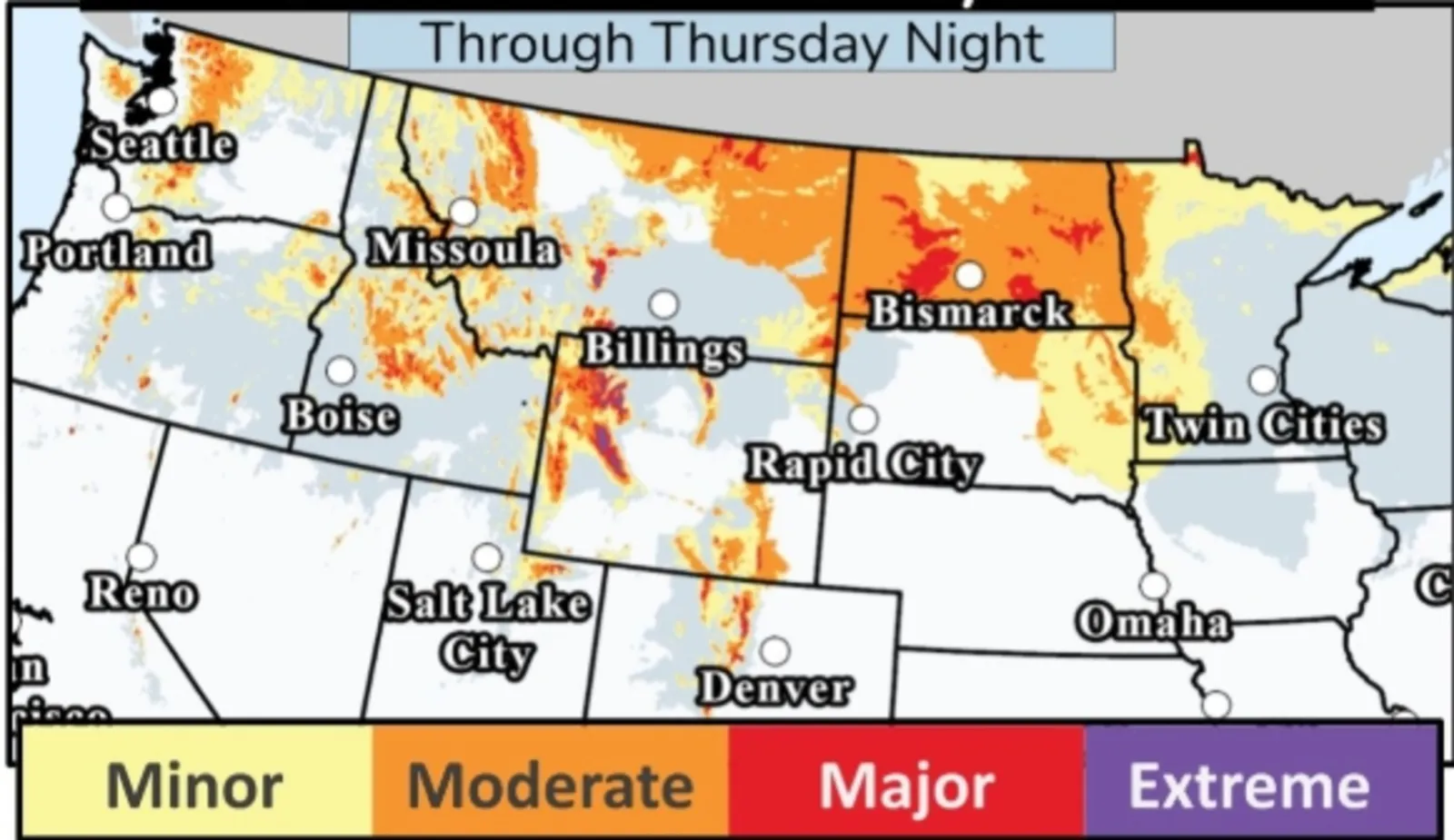
A map included with the post on X showed that while the entirety of the Northern Plains was expected to see some impacts from the storm, some states will likely be hit by widespread major impacts. These include Montana, Wyoming, North Dakota, Colorado and Idaho.
...
Winter storm warnings, blizzard warnings, and even a civil emergency message are already in place across the impacted region. In some areas, snow has begun to fall.
In North Dakota, a blizzard warning stretches across the entire northern half of the state. NWS lead meteorologist Nathan Heinert said near-zero visibility will make travel dangerous, and the most widespread blizzard conditions will occur after midnight through Thursday morning.
Following the blizzard, Thursday's temperatures will plunge 30 to 40 degrees below Wednesday's highs.
Blizzard warnings were in place for northeastern Montana, North Dakota, and northwestern Minnesota.
"Widespread blowing snow could significantly reduce visibility. The hazardous conditions could impact the Thursday morning commute. Very strong winds could cause damage to trees and power lines," the NWS office in Bismarck said. "Travel should be restricted to emergencies only."
Snow is also expected in areas not under blizzard warnings, which could also contribute to poor travel conditions.
"Travel could be very difficult to dangerous and tire chains may be required for some vehicles," NWS Great Falls said in a winter storm warning. "Visibility may drop below 1/4 mile at times due to falling and blowing snow. Those in the backcountry should ensure they are prepared for dangerous conditions."
In some high-elevation areas, such as the Absaroka/Beartooth Mountains, it was possible for snowfall to surpass 2 feet.
For areas expecting major winter weather impacts, NWS meteorologists warned that people should "expect considerable disruptions to normal activities."
"Dangerous or impossible traveling conditions. Avoid travel in the impacted areas if possible," NWS Missoula said in a winter storm warning. "Widespread closures and disruptions to infrastructure may occur. The hazardous conditions could impact the Wednesday evening commute, especially over higher passes. Strong winds could cause tree damage."
View 0 Comments
Submit Correction
View Editorial & AI Guidelines