...

By Anna Skinner
Associate News Editor
0
Share
Newsweek is a Trust Project member
See more of our trusted coverage when you search.Prefer Newsweek on Googleto see more of our trusted coverage when you search.
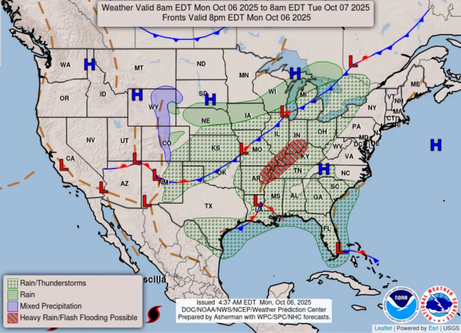
Seven states are at risk of heavy rain and possible flash floods on Monday, according to a map from the National Weather Service (NWS) Weather Prediction Center.
Newsweek reached out to the NWS center via phone for comment.
Why It Matters
Behind extreme heat, flooding is the second leading cause of weather-related deaths. During times of heavy rain, rivers and streams can rise quickly. Flash floods give people little time to act, making any alert extremely important.
Read More on U.S.
What To Know
The national forecast chart published by the NWS Weather Prediction Center on Monday outlined a risk of heavy rain and flash floods for southern Indiana, southeastern Illinois, western Kentucky, western Tennessee, far southeastern Missouri, northeastern Arkansas and far northwestern Mississippi.
...
"Above average moisture from the Gulf is expected to stream northward and pool near the front, providing a focus for heavy rainfall across parts of the Lower Mississippi Valley, Mid-South, and Lower Ohio Valley today into tonight," an NWS forecast on Monday said. "A Slight Risk (level 2/4) of excessive rainfall causing scattered flash flooding is in place for these areas."
As of around 3 p.m. ET Monday, NWS meteorologists had issued a flood advisory for parts of eastern Arkansas, but no widespread alerts had been issued.
The NWS forecast warned that the risk of heavy rain and flash flooding would shift farther into Kentucky on Tuesday.
"Areas of 3 to 5 inches of rain are possible," the forecast said. "Some rain is forecast to stretch northward into the Great Lakes today and Northeast and Mid-Atlantic on Tuesday, but not quite as heavy as farther south."
A much wider area of the U.S. could expect rain and thunderstorms throughout the day on Monday, according to the map. The chance for thunderstorms extended from Florida and Texas up through Michigan.
What People Are Saying
NWS Weather Prediction Center, in a post to X on Monday: "Heavy rain and flooding potential across parts of the Mid-South and Ohio Valley."
NWS office in Paducah, Kentucky, in a hazardous weather outlook: "Scattered thunderstorms are possible today into tonight. Heavy rainfall and isolated flooding is possible. ... Scattered thunderstorms are possible on Tuesday. Training storms will be capable of causing some flooding issues Tuesday morning into early Tuesday afternoon particularly over the Kentucky Pennyrile."
What Happens Next
Looking further out, the NWS Weather Prediction Center forecasts the threat of thunderstorms will largely shift to the Eastern Seaboard by Wednesday, though the threat of heavy rain and flash floods would diminish after Tuesday. People living in areas that were expecting storms should follow the guidance of local weather officials.
View 0 Comments
Submit Correction
View Editorial & AI Guidelines