...

By Hollie Silverman
News Editor
0
Share
Newsweek is a Trust Project member
See more of our trusted coverage when you search.Prefer Newsweek on Googleto see more of our trusted coverage when you search.
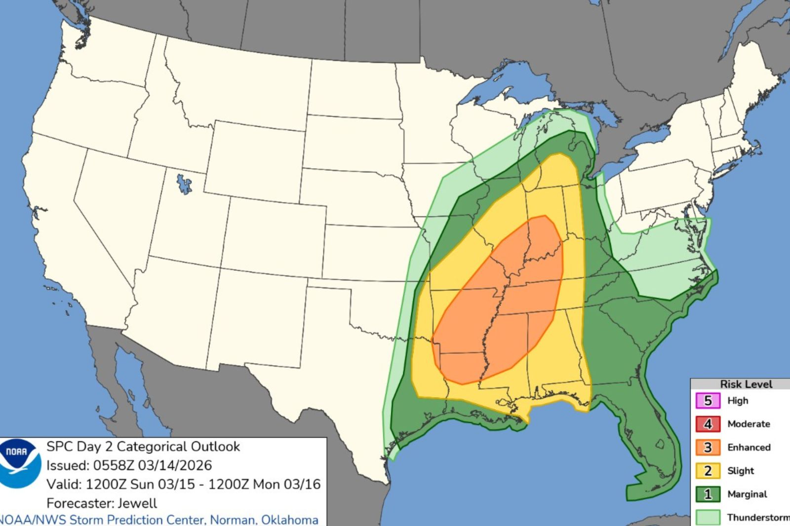
The National Weather Service’s (NWS) Storm Prediction Center (SPC) shows an enhanced risk of severe thunderstorms and possible tornadoes across portions of nine states for Sunday.
"Scattered to widespread damaging winds along with tornadoes should develop on Sunday afternoon, persisting through Sunday night across a large portion of the South-Central/Southeast States into the Midwest/Ohio Valley," the SPC forecast said.
"The greatest strong tornado and significant severe wind threats appear to be from the Ark-La-Miss to the Lower Ohio Valley on Sunday evening," the alert read.
Read More on News
The Context
The country has seen multiple deadly tornadoes across Illinois and Indiana over the last week, with many communities still working to recover.
The SPC noted a setup supportive of strong tornadoes and significant severe winds, raising concern for high-impact storms in populated corridors ahead of a fast-moving cold front.
...
What To Know
The SPC said an upper trough will amplify across the central U.S. on Sunday, becoming centered from Wisconsin to the Ark-La-Tex region by Monday morning, while a surface low deepens as it moves from the Iowa–Missouri border toward Lower Michigan Sunday evening into the night.
As the system strengthens, an accelerating cold front will sweep east across the mid-Mississippi Valley into the Ohio Valley, with the trailing front pushing toward the northwest Gulf and central Gulf Coast by Monday morning, focusing thunderstorm development along and ahead of the boundary.
The outlook added a 10 percent tornado area within the enhanced-risk corridor, expanded the 45 percent damaging-wind area southward, and introduced 15 percent and CIG1 (hatched) hail areas to reflect significant severe potential, while also expanding marginal and slight risks over parts of the Southeast late Sunday night into early Monday.
Forecasters expected midday storm development along a convergent front from the mid-Mississippi Valley into the Ozarks, with coverage increasing as storms tap richer moisture toward the Ark-La-Tex and the Mid-South through the afternoon.
By late afternoon, the SPC anticipated a long quasi-linear convective system from Illinois south-southwestward, while semi-discrete supercells near and south of the front could initially produce large hail and a couple of strong tornadoes before merging into the broader line.
Through the evening, strengthening winds across the Mid-South expanding into the Ohio and Tennessee valleys will favor scattered to widespread damaging wind swaths, with the northern extent of the severe threat becoming more sporadic Sunday night as near-surface instability wanes.
The outlook also signaled renewed low-level convection near the central to northeast Gulf Coast early Monday, with deep-layer shear supportive of semi-discrete supercells capable of large hail and sustained tornado potential from at least the Florida Panhandle toward the southern Appalachians.
Which States Are at Risk?
Geographically, the risk corridor on Sunday spans portions of the Ark-La-Tex and Ark-La-Miss regions into Illinois and the Lower Ohio Valley, with the broader severe-weather area extending across parts of the South-Central and Southeast states into the Midwest and Ohio Valley as the front advances.
Indiana, Tennessee, Kentucky and Louisiana are among the states with enhanced risk while Georgia, Missouri and Ohio are listed as a slight risk by the NWS.
Marginal risks exist for parts of Texas, Michigan, Wisconsin and the Carolinas.
"Severe storms across parts of western Kentucky into western Tennessee, including cities such as Paducah, Kentucky; Nashville and Memphis, Tennessee, can occur at night, which can be especially dangerous,” Dan Pydynowski, AccuWeather senior meteorologist said in a statement emailed to Newsweek on Saturday.
What Does a Tornado Watch Mean?
When the NWS issues tornado alert watches, it means weather conditions are favorable for tornadoes to form. Tornadoes are possible but not yet occurring. Meanwhile, a tornado warning alert indicates a tornado has been spotted or detected by radar and immediate action is required.
These watches are issued by the NOAA Storm Prediction Center (SPC) and coordinated with local NWS offices.
Residents within the tornado watch area are advised to review their safety plans, monitor weather updates, and be ready to move to a basement or interior room if a tornado warning is issued.
Meteorologists Weigh In
Dan Pydynowski, AccuWeather senior meteorologist, said in a statement emailed to Newsweek on Saturday: "People in these areas should have their phones charged, a NOAA weather radio and audible alerts enabled on the AccuWeather app for when they go to bed at night so they can be woken up to take shelter if damaging winds or tornadoes approach their house.”
Jonathan Porter, AccuWeather chief meteorologist, said in a statement emailed to Newsweek on Saturday: "One area of particular concern is the southern United States, where communities are still recovering from the major January ice storm. While this type of setup can cause significant tree damage and power outages at any time, the threat may be heightened in this region because many trees and branches could have been weakened by the recent ice storm.”
What Happens Next
The SPC will issue the next Day 2 Outlook later Saturday, and updates will likely refine exact corridors of greatest tornado and damaging-wind potential as new model data and observations arrive.
Update 3/14/26, 5:37 p.m. ET: This article has been updated with comment from Pydynowski and Porter.
In a polarized era, the center is dismissed as bland. At Newsweek, ours is different: The Courageous Center—it's not "both sides," it's sharp, challenging and alive with ideas. We follow facts, not factions. If that sounds like the kind of journalism you want to see thrive, we need you.
When you become a Newsweek Member, you support a mission to keep the center strong and vibrant. Members enjoy: Ad-free browsing, exclusive content and editor conversations. Help keep the center courageous. Join today.


Update 3/14/26 5:34 p.m. ET: This story has been updated with more information.
View 0 Comments
Submit Correction
View Editorial & AI Guidelines