
...

By Hollie Silverman
News Editor
0
Share
Newsweek is a Trust Project member
See more of our trusted coverage when you search.Prefer Newsweek on Googleto see more of our trusted coverage when you search.
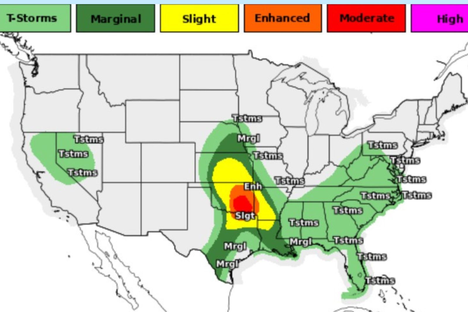
A National Weather Service (NWS) forecast map on Saturday shows a broad swath of the Southern Plains in the path of a significant tornado and large‑hail threat this weekend.
Multiple states, including Oklahoma, northeast Texas and western Arkansas, are under hazard warnings, with the highest risk centered over the Oklahoma City metro and surrounding areas, according to the NWS.
The new risk comes as Oklahoma continues to recover from destructive storms that tore through homes earlier this week.
Read More on News
Why It Matters
Forecasters warn that supercell thunderstorms capable of producing strong tornadoes (EF2+), destructive hail up to 3–4 inches, and damaging winds are expected to develop this afternoon and evening.
This is the type of setup that can produce high‑impact, fast‑moving storms during peak weekend activity, increasing the risk to people on the road, at outdoor events, or in areas with limited shelter options.
The Storm Prediction Center (SPC) notes the environment is primed for intense rotating storms.
...
What To Know
The SPC map places a large region of Oklahoma, northeast Texas, and western Arkansas under severe‑weather risk, with the most significant threat stretching from the Oklahoma City and Norman areas south toward Dallas and Paris, Texas.
Supercells are expected to form this afternoon and evening, with storms likely continuing into the night as they merge into clusters.
NWS forecasters say supercells will dominate early, increasing the tornado and giant‑hail threat. Later, storm clusters may expand the damaging‑wind footprint.
The exact locations and timing of the storm remain fluid. Forecasters emphasize details will become clearer through the day as new data arrives.
In an X post on Saturday, Senator James Lankford, an Oklahoma Republican, told residents to make a plan tonight.
"Oklahoma, make a plan tonight," he wrote. "Stay weather aware, listen to your local stations, and be ready to take shelter. Preparedness saves lives, as we saw in Enid with the EF-4 tornado. Join me in lifting up everyone in prayer tonight."
...
Damaging Storm Season Begins
NWS meteorologists note this week marked the start of a multi‑day severe weather pattern across the Central Plains, with conditions favorable for supercells capable of producing tornadoes, giant hail, and damaging winds.
A powerful EF‑4 tornado tore through Enid, Oklahoma, on Thursday night, destroying dozens of homes and leaving parts of the city covered in debris, though officials say there were no fatalities.
A violent, long‑track tornado struck the south side of Enid, leveling homes in the Gray Ridge neighborhood, toppling power poles and ripping roofs from buildings. Emergency crews reported residents trapped in damaged houses and conducted door‑to‑door searches through the night.
Images from the Associated Press show people surveying the extensive damage following the storm, with families going through the debris of their homes looking for belongings.

...
Vance Air Force Base also sustained damage, prompting temporary closure while officials assessed impacts and accounted for personnel. Despite the destruction, state and local leaders credited early warnings and quick sheltering for preventing loss of life.
Kansas endured a volatile stretch of severe weather this week, with multiple tornadoes striking communities from Miami and Franklin counties to Morris County and beyond. The most destructive impacts came from a pair of EF‑2 tornadoes that hit Hillsdale and Ottawa, damaging or destroying dozens of homes and commercial buildings.
In Hillsdale, an EF‑2 with 115 mile per hour winds affected more than a hundred structures and left one person with minor injuries, while in Ottawa, another EF‑2 tracked south of town, injuring three people and heavily damaging a manufacturing plant.
At Lake Kahola in Morris County, an EF‑1 tornado with 110 mph winds tore through a cluster of cabins, flipping boats, destroying garages, and uprooting trees, though no injuries were reported. Damage surveys across these regions documented widespread debris fields, snapped power poles, and long stretches of downed lines, according to KSN.
The week’s severe weather wasn’t limited to classic supercell tornadoes. A landspout north of Wichita briefly touched down, the outlet reported. Large hail also caused significant damage, with baseball‑sized stones falling in Marion County and tennis‑ball‑sized hail reported in Sumner County, shattering windows and denting vehicles across multiple towns.
Together, the tornadoes, hailstorms, and high winds marked one of the most active severe‑weather stretches of the spring so far in the region.
What Happens Next
Meteorologists will refine the forecast through the afternoon as storms begin to develop.
Residents in the risk area should monitor updates from the SPC and NWS. They should also be prepared for tornado watches and warnings, have multiple ways to receive alerts, and review shelter plans.
View 0 Comments
Submit Correction
View Editorial & AI Guidelines