NWS Weather Prediction Center

By Anna Skinner
Associate News Editor
0
Share
Newsweek is a Trust Project member
See more of our trusted coverage when you search.Prefer Newsweek on Googleto see more of our trusted coverage when you search.
Another arctic blast is expected to descend into the U.S. this weekend, plunging temperatures to subzero levels for millions.
The forecast comes as Florida and the rest of the Southeast continues to recover from a significant drop in temperatures over the weekend, prompting snow flurries as far south as Tampa. The most significant temperatures will hit the Northeast and Mid-Atlantic this weekend.
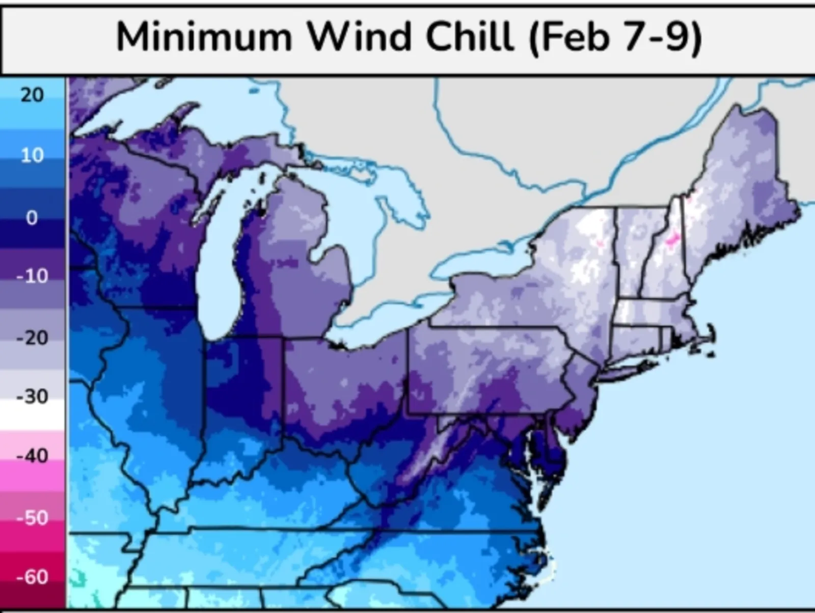
"A significant arctic outbreak will bring bitterly cold temperatures and dangerous wind chills to the Northeast and Mid-Atlantic this weekend," the National Weather Service (NWS) Weather Prediction Center said in a key message published on Monday. "Much below-normal temperatures are forecast, with record-breaking cold possible in some areas. Gusty winds will exacerbate conditions, producing widespread subzero wind chills. Brief periods of intense snowfall, including snow squalls, are possible with the arrival of the cold air."
Read More on News
The coldest weather is expected in Northern Vermont, with meteorologists warning that temperatures could feel as cold as 40 degrees below zero when wind chill is taken into account. Northern and Central New York, Western Massachusetts, parts of New Hampshire, much of Vermont and part of Maine could feel as cold as 30 degrees below zero. Much of the rest of the Northeast, Mid-Atlantic and Midwest will feel around 10 degrees below zero or colder, depending on the location.
...
NWS meteorologist Chris Legro, who works at the Gray, Maine, forecast office, told Newsweek that if the office were to issue any cold weather advisories or extreme cold warnings, it would likely occur on Thursday night or Friday.
Actual temperatures will also be below zero, with wind chill exacerbating how cold the temperatures actually feel. The temperature and wind chills will be "dangerous," Legro said, particularly into Sunday morning.
How Much Snow Is Expected?
Accumulating snowfall is more likely earlier in the week, ahead of the frigid temperatures, according to data from the NWS. Winter weather advisories are currently in place for parts of Indiana, Ohio, West Virginia, and Kentucky, and the alerts are expected to remain active through Tuesday night or early Wednesday morning depending on the location.
The advisories warn of up to 4 inches of snowfall, depending on the location.
This weekend, the biggest threat will be the cold temperatures, with AccuWeather warning of snow showers and snow squalls from Indiana northeast through Maine on Friday night.
"Snow showers and snow squalls are going to accompany the arctic cold front as it traverses the Northeast on Friday. These snow showers and squalls can limit visibility and lead to roads becoming snow-covered and icy quickly," AccuWeather Meteorologist Peyton Simmers said in a report.
When Will Arctic Blast Hit?
The plunging temperatures will likely occur this weekend, the forecast said. Snow showers associated with the incoming cold air could arrive as early as Friday night, with the arctic blast hitting by Saturday, AccuWeather reported.
How Long Will Cold Last?
Meteorologists warned of long-duration cold with the incoming drop in temperatures.
Extreme cold could linger until at least February 11, the NWS Weather Prediction Center warned in its most recent key message about the arctic blast. Temperatures will then begin to moderate toward more normal levels for this time of year by late next week.
Looking further ahead, temperatures in the Northeast are expected to be near normal averages between February 10 and 16, according to the eight- to 14-day temperature outlook from the NWS Climate Prediction Center. Meanwhile, the Mid-Atlantic, Midwest, and much of the rest of the U.S. are expecting above-average temperatures during the same time period.
View 0 Comments
Submit Correction
View Editorial & AI Guidelines