...

By Alia Shoaib
Reporter
0
Share
Newsweek is a Trust Project member
See more of our trusted coverage when you search.Prefer Newsweek on Googleto see more of our trusted coverage when you search.
Parts of the central and northern U.S. are expected to see colder temperatures than usual during Thanksgiving week due in part to a potential disruption of the polar vortex.
The National Weather Service (NWS) noted that a combination of weather conditions may create “winter-like conditions across much of the U.S. late November into early December.”
Why It Matters
Colder-than-usual temperatures during Thanksgiving week could affect millions of Americans, particularly during peak holiday travel.
Read More on News
What To Know
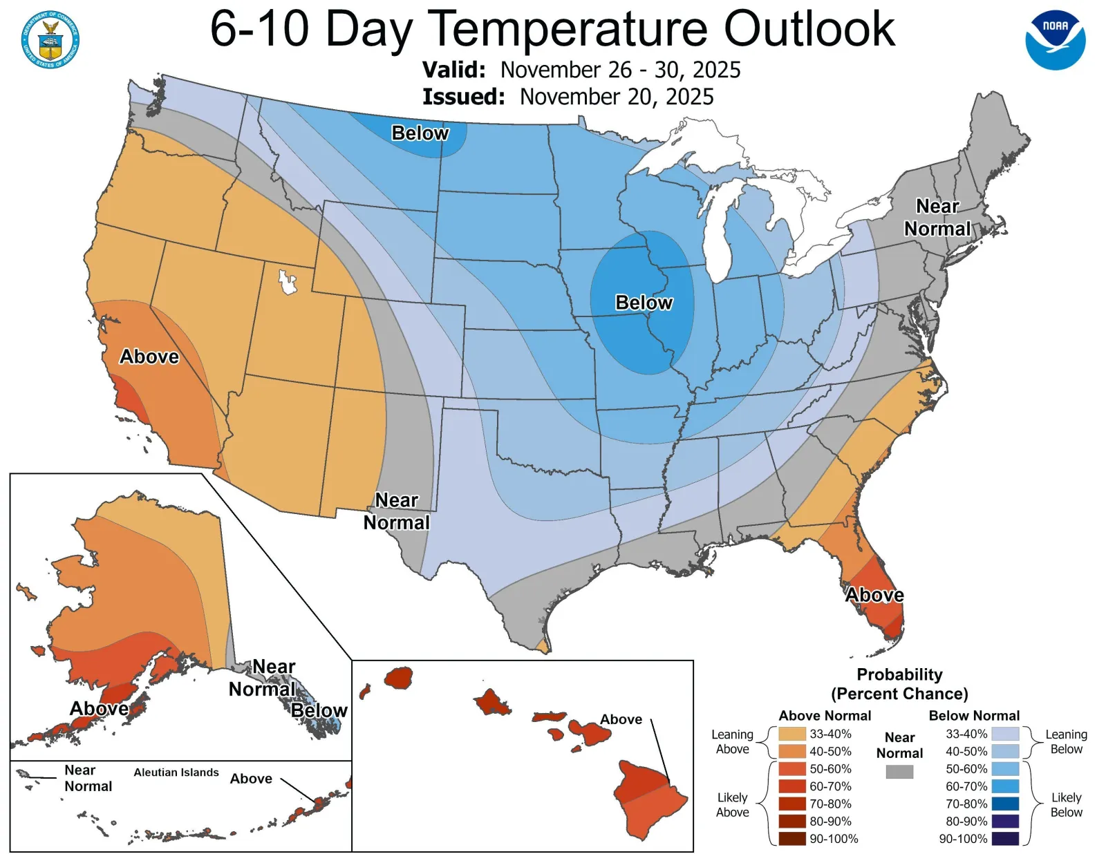
According to the NWS forecast map, large portions of the country will likely see colder temperatures than normal between November 26 and 30.
Parts of Missouri, Iowa, Illinois and Wisconsin are 60 percent to 70 percent likely to see temperatures below normal, as are small portions of Montana and North Dakota.
A wider swathe of the central U.S.—from Montana in the north, south to parts of northern Texas and eastward toward the edge of New York—is also expected to experience below-normal temperatures.
Probabilities of low temperatures across this area range from 33 percent to 40 percent in some areas up to 50 percent to 60 percent in others.
...
Meanwhile, some parts of the west and Florida could see above-normal temperatures.
The colder than usual temperatures are being driven by a combination of factors, the NWS noted.
A potential disturbance in the polar vortex—a band of strong winds that normally keeps cold Arctic air locked over the North Pole—could allow cold air to spill south across much of the central U.S.
Such a disturbance could be caused by a rare November Sudden Stratospheric Warming event, which warms the upper atmosphere above the Arctic and, in doing so, weakens the polar vortex, letting the frigid air escape south.
This pattern is also being impacted by La Niña, the recurring climate pattern that marks the surface waters of the Pacific Ocean being cooler than normal, which can influence weather patterns.
The Madden-Julian Oscillation, a recurring pattern of moving clouds and winds, can help push Arctic air south and add to the cold conditions.
What People Are Saying
WFLA-TV Tampa Bay meteorologist Jeff Berardelli, on X: “To be clear: Disruption of the Stratospheric polar vortex is a natural process, it happens almost every or every few winters. Nothing nefarious is causing these. Scientists are investigating how climate change / Arctic Amplification etc… factors in and IF it is making them more common, but these warming events happen in a normal climate.”
Dr. Judah Cohen, a climatologist at MIT who also works with JANUS Research Group, told ABC News: "We have this unprecedented disruption in the polar architecture where it's so early in the season....There's not many past analogs to draw from and say [with confidence] about how this is going to go."
What Happens Next
Forecasters will continue monitoring weather patterns to track how temperatures could develop over the coming days and weeks. It is still unclear whether the polar vortex will be fully disrupted or just stretched, but either way it can bring colder temperatures than usual for this time of year.
The NWS said that below-normal temperatures may start as early as November 25.
View 0 Comments
Submit Correction
View Editorial & AI Guidelines