...

By Anna Skinner
Associate News Editor
0
Share
Newsweek is a Trust Project member
See more of our trusted coverage when you search.Prefer Newsweek on Googleto see more of our trusted coverage when you search.
Several East Coast states could see up to 4 inches of rain this weekend as a slow-moving storm similar to a Nor'easter works its way up the Atlantic Coast.
"In a case like this, the wind and the rain have the potential to be working on a couple level in tandem," National Weather Service (NWS) Weather Prediction Center (WPC) meteorologist Richard Bann told Newsweek. "If we have 55 mph wind gusts and periods of heavy rain, it leads to some flooding concerns."
Bann also warned of rip currents and beach erosion.
Read More on U.S.
Why It Matters
The NWS WPC began issuing key messages for the storm earlier this week. Meteorologists with the agency said the impending coastal storm would bring "strong wind gusts, heavy rainfall, and significant coastal impacts," including coastal flooding, rip currents and beach erosion to parts of the East Coast this weekend.
Many NWS offices have already issued weather alerts related to the storm, including gale watches, coastal flood watches, and storm watches.
...
What to Know
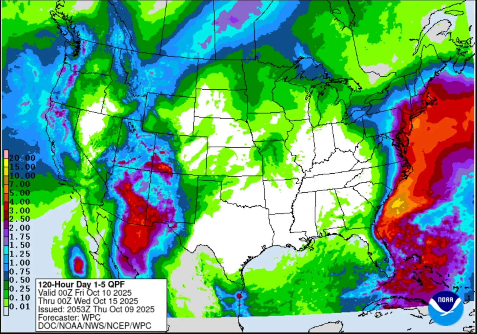
On Thursday, the NWS WPC released a map showing anticipated rainfall amounts up to 4 inches in coastal Massachusetts, Delaware and Maryland.
"There is an increasing threat of wind gusts in excess of 55 MPH and periods of heavy rain in coastal areas of the Mid Atlantic and Long Island with the potential for scattered power outages and damage," the NWS WPC said in an updated key message about the storm. "The heavy rain may also extend into southern New England. Heavy rain may cause additional inland flooding."
Up to 3 inches of rain were forecast over a much more widespread area, including North Carolina, Virignia, Pennsylvania, New Jersey, New York, Connecticut, Rhode Island, New Hampshire and Maine.
Weather alerts related to the storm have been issued along the entire Eastern Seaboard. The storm is currently located off the coast of Georgia but will continue working its way northward into the weekend and early next week. Tropical storm-like impacts will batter coastal North Carolina north through New Jersey from Friday night through Monday.
"There is a high risk this storm will be designated a subtropical (hybrid) storm, which is why we have designated this system as a tropical wind and rainstorm, and have issued an eye path map to raise early awareness ahead of potential National Hurricane Center (NHC) classification," AccuWeather lead hurricane expert Alex DaSilva said in a report.
A map included in the report shows the storm trekking along the East Coast through Monday night, before making a sharp turn out to sea.
What People Are Saying
AccuWeather chief on-air meteorologist Bernie Rayno said in a report: "This will be a damaging storm for some along the Atlantic coast."
NWS Mount Holly, New Jersey, in a coastal flood watch: "At this level, flooding may become severe enough to cause structural damage along with widespread roadway flooding in coastal and bayside communities, and near inland tidal waterways. Some locations may become isolated by the flood waters."
What Happens Next
Most weather alerts related to the storm will go into effect this weekend. People residing along the Eastern Seaboard, particularly in coastal areas, should take preventative measures to protect their property and follow guidance of local weather officials as the storm progresses.
View 0 Comments
Submit Correction
View Editorial & AI Guidelines