
...

By Anna Skinner
Associate News Editor
0
Share
Newsweek is a Trust Project member
See more of our trusted coverage when you search.Prefer Newsweek on Googleto see more of our trusted coverage when you search.
Rivers across Michigan and Wisconsin are reaching or forecast to reach major flood stage, prompting warnings that significant evacuations may be necessary as water levels continue to rise across the Great Lakes region.
The entire state of Michigan and much of eastern Wisconsin remains under some form of National Weather Service (NWS) flood alert on Wednesday following a days-long deluge that has saturated the region. Powerful thunderstorms—some capable of producing tornadoes and damaging winds—have swept across Michigan and Wisconsin over several days, overwhelming drainage systems and rapidly boosting river flows.
“Many of the rivers across central Wisconsin, eastward into northern lower Michigan, are either at major flood stage or are forecast to reach major flood stage over the next couple of days. Unfortunately, more rain is on the way," AccuWeather senior meteorologist John Feerick told Newsweek.
Read More on Weather
...
Major flood is a category that typically signals widespread inundation of homes, road closures, and threats to critical infrastructure, in which "significant evacuations of people and/or transfer of property to higher elevations" are possible, according to the National Water Prediction Service.
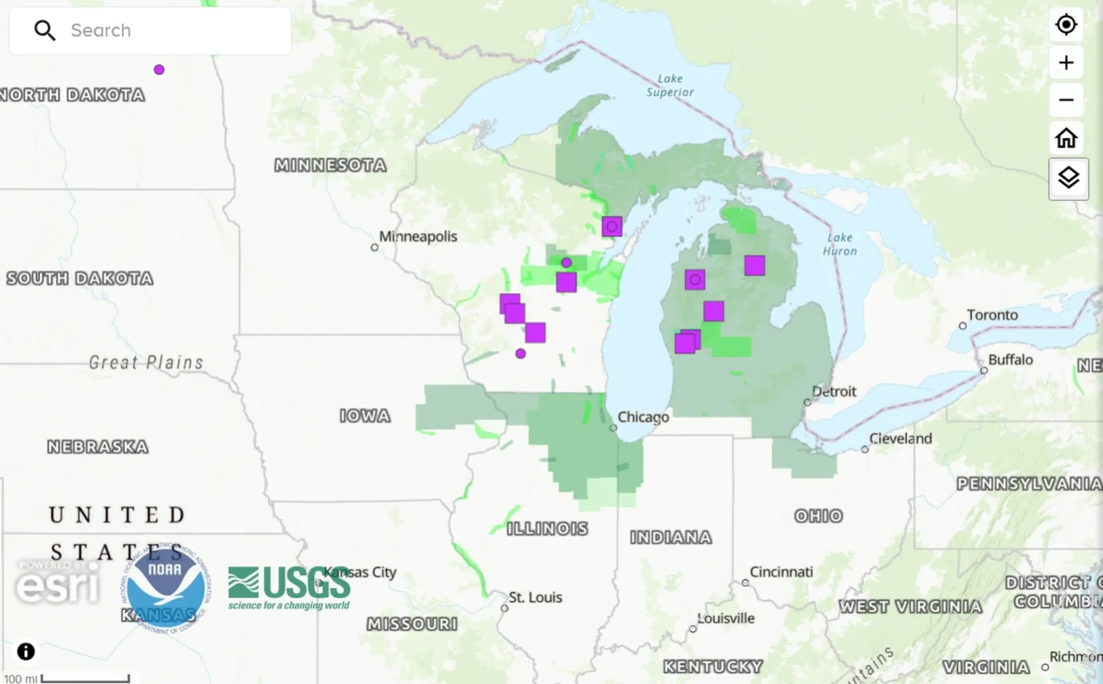
...
The map highlights elevated risk along parts of northern and eastern Wisconsin and northern Lower Michigan, where rivers remain swollen from heavy rain, rapid runoff, and earlier snowmelt.
Wisconsin Floods
Emergency officials in Wisconsin have already urged residents near vulnerable waterways to prepare to leave on short notice. In recent days, evacuations have begun downstream of dams considered at risk, with emergency managers warning of potentially life‑threatening flash flooding if water levels continue climbing. NOAA data shows seven Wisconsin rivers either at or forecast to hit major flood stage, with authorities closely monitoring levees, bridges and low-lying neighborhoods.
The impacted rivers include: Menominee River near McAllister, Embarrass River near Embarrass, Wolf River at New London, Yellow River at Necedah, Wisconsin River at Castle Rock Dam, Wisconsin River at Portage, and Black Earth Creek at Mazomanie.
Michigan Floods
Across Michigan, flood concerns are also escalating. NOAA river-gauge forecasts indicate that several Michigan rivers could approach or exceed major flood-stage levels, pushing communities toward evacuation decisions if forecast rain materializes later this week. State officials have activated emergency operations in northern parts of the state, where rising rivers and dam concerns have already disrupted transportation and public services.
Rivers impacted by major flooding include: Au Sable River near Red Oak, Manistee River near Sherman, Muskegon River at Evart, Muskegon River at Newaygo, and Muskegon River at Bridgeton.
Forecasters say additional rounds of rain falling on already saturated ground could drive rivers higher, expanding flood zones shown on the federal map and increasing the likelihood of mandatory evacuations.
"More rain and thunderstorms are expected Wednesday night into Thursday," Feerick told Newsweek. "This deluge will mean the flood threat is likely to get much worse before it gets better. Another chance for showers and thunderstorms will move through Wisconsin and Michigan Friday night into Saturday. After that rain, there may be a needed stretch of dry weather from later in the weekend into early next week.”
Residents in flood‑prone areas are urged to closely monitor local alerts, avoid flooded roadways, and be ready to move quickly if evacuation orders are issued.
View 0 Comments
Submit Correction
View Editorial & AI Guidelines