...

By Soo Kim
Reporter
0
Share
Newsweek is a Trust Project member
See more of our trusted coverage when you search.Prefer Newsweek on Googleto see more of our trusted coverage when you search.
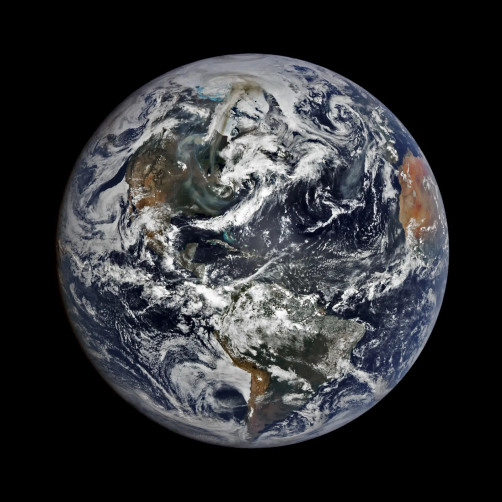
A new satellite image released by NASA has captured dramatic clouds of smoke and dust from the wildfires that have ravaged parts of Canada.
The plumes from some blazes were so thick and widespread that they could be seen from a viewpoint in space well beyond that of the moon.
The image was taken on May 31 by NASA's EPIC (Earth Polychromatic Imaging Camera) on the DSCOVR satellite of the National Oceanic and Atmospheric Administration (NOAA).
Read More on Science
EPIC is positioned a million miles from the Earth's surface, around four times farther than the orbit of the moon.
(For comparison's sake, most polar orbiting satellites observe the Earth fat an altitude of less than 621 miles.)
...
The satellite image captures smoke mostly from the fires in the Canadian provinces of Manitoba and Saskatchewan. The plumes extend north across Nunavut, Canada's largest and northernmost territory, and toward the coast of Greenland and south across the United States.
A patch of smoke is also visible over the Atlantic Ocean near Europe, while "the hazy air west of Africa is not smoke but dust that has blown westward from the Sahara Desert," NASA notes.
More than 180 wildfires were reported to have burned across Canada on Sunday, with air quality and visibility worsening in Canada and in some U.S. states along the border.
This marks the first instance of excessive Canadian wildfire smoke descending into the U.S. since 2023 when wildfires worsened air quality to dangerous levels for millions in the northeast.
Air quality has degraded in several parts of the U.S., including in Michigan, which issued an advisory last week, warning residents that "conditions maybe unhealthy for sensitive groups and there is a possibility that hourly levels could reach the unhealthy range for a short period of time."
On Monday, an advisory was also issued in Minnesota warning residents that the air quality is expected to reach a level that is "hazardous for everyone." The advisory is in effect until Wednesday.
The jet stream has sent the plumes further south, with an image captured by NASA's VIIRS (Visible Infrared Imaging Radiometer Suite) on the NOAA-21 satellite showing smoke reaching northern Florida.

...
Over 25,000 residents have been evacuated across three Canadian provinces as dozens of wildfires remained active Sunday.
A state of emergency was declared in Manitoba last week, where by Saturday around 17,000 people had been evacuated, along with 1,300 in the Alberta province. About 8,000 in the Saskatchewan province were relocated, with leaders warning the figure may rise, the Associated Press reported Sunday.
The wildfire season in Canada runs from late April to August, but fires can occur at any time of the year.
So far this year, 1,586 fires have scorched more than a million hectares of Canada, according to a report on June 1 by the Canadian Interagency Forest Fire Center.
Last year, the country saw 1,343 fires burn less than half a million hectares by the same date.
Do you have a tip on a science story that Newsweek should be covering? Do you have a question about wildfires? Let us know via science@newsweek.com.
View 0 Comments
Submit Correction
View Editorial & AI Guidelines