
...

By Anna Skinner
Associate News Editor
0
Share
Newsweek is a Trust Project member
See more of our trusted coverage when you search.Prefer Newsweek on Googleto see more of our trusted coverage when you search.
A series of winter weather forecast maps from the National Weather Service (NWS) Weather Prediction Center reveals the path of an incoming winter storm set to hit the U.S. this weekend.
The forecasts come only days after Winter Storm Fern ravaged the U.S. South, Midwest, Mid-Atlantic, and Northeast last weekend. The storm killed at least 45 people, the Associated Press reported, and hundreds of thousands remain without power on Wednesday as cities across the U.S. South try to repair infrastructure amid lingering ice and freezing temperatures. Now, another winter storm is set to hit the U.S. Southeast and Eastern Seaboard this weekend, possibly compounding impacts from the first system. However, the areas hit hardest by the first system—such as Texas, Northern Mississippi, and Western and Central Tennessee will likely not be as impacted by the incoming storm, AccuWeather senior meteorologist Tom Kines told Newsweek.
...
Read More on U.S.
The new maps from the NWS Weather Prediction Center show that a chance of widespread minor impacts from the storm is expected to ramp up on Saturday and persist throughout the day on Sunday before the system begins to exit the nation by Monday.
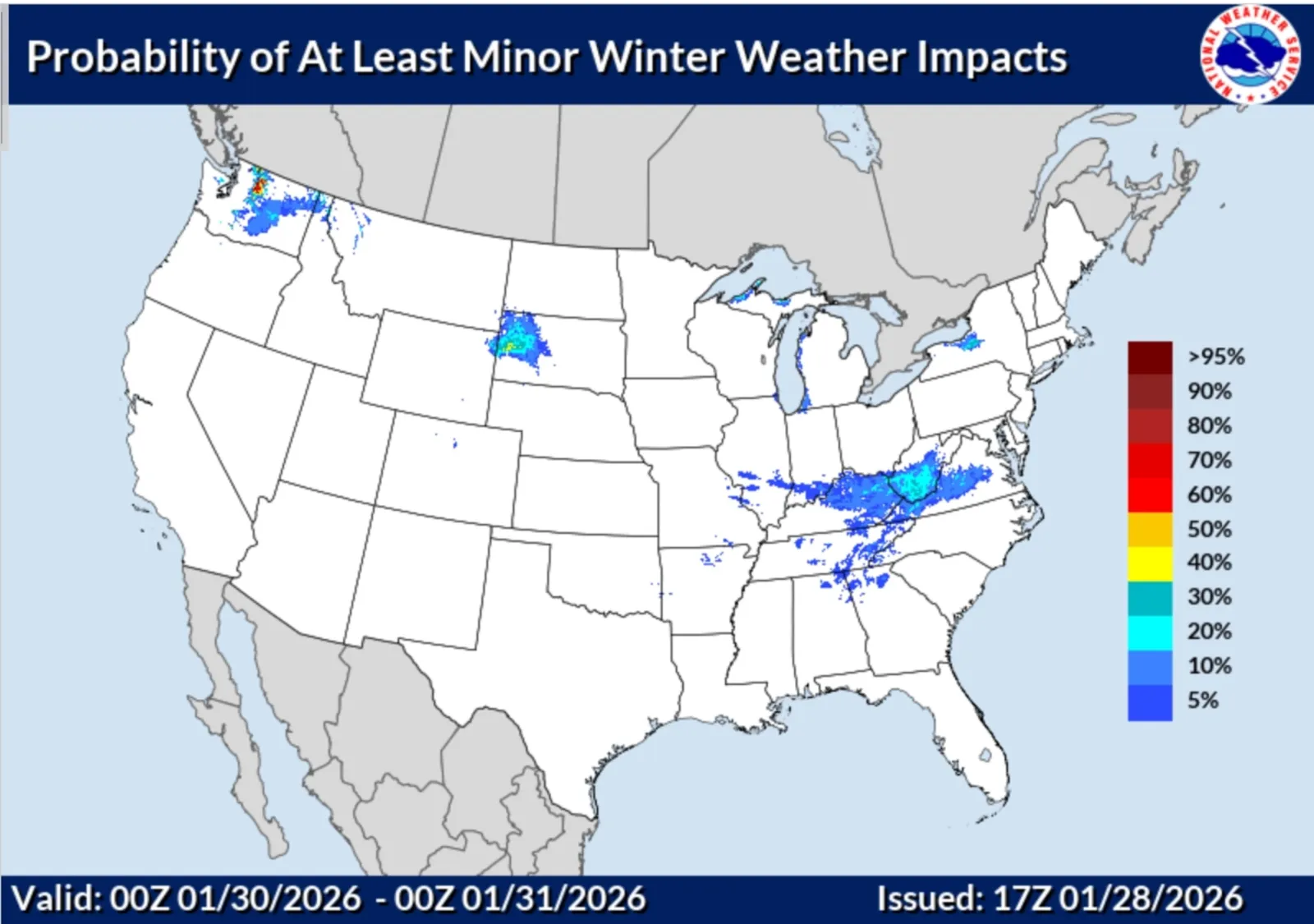
Friday Winter Storm Impacts
There is a low chance of minor winter weather impacts beginning across the South and Mid-Atlantic on Friday. West Virginia is the state with the highest chance of experiencing minor winter weather impacts on this day, at around 30 percent.
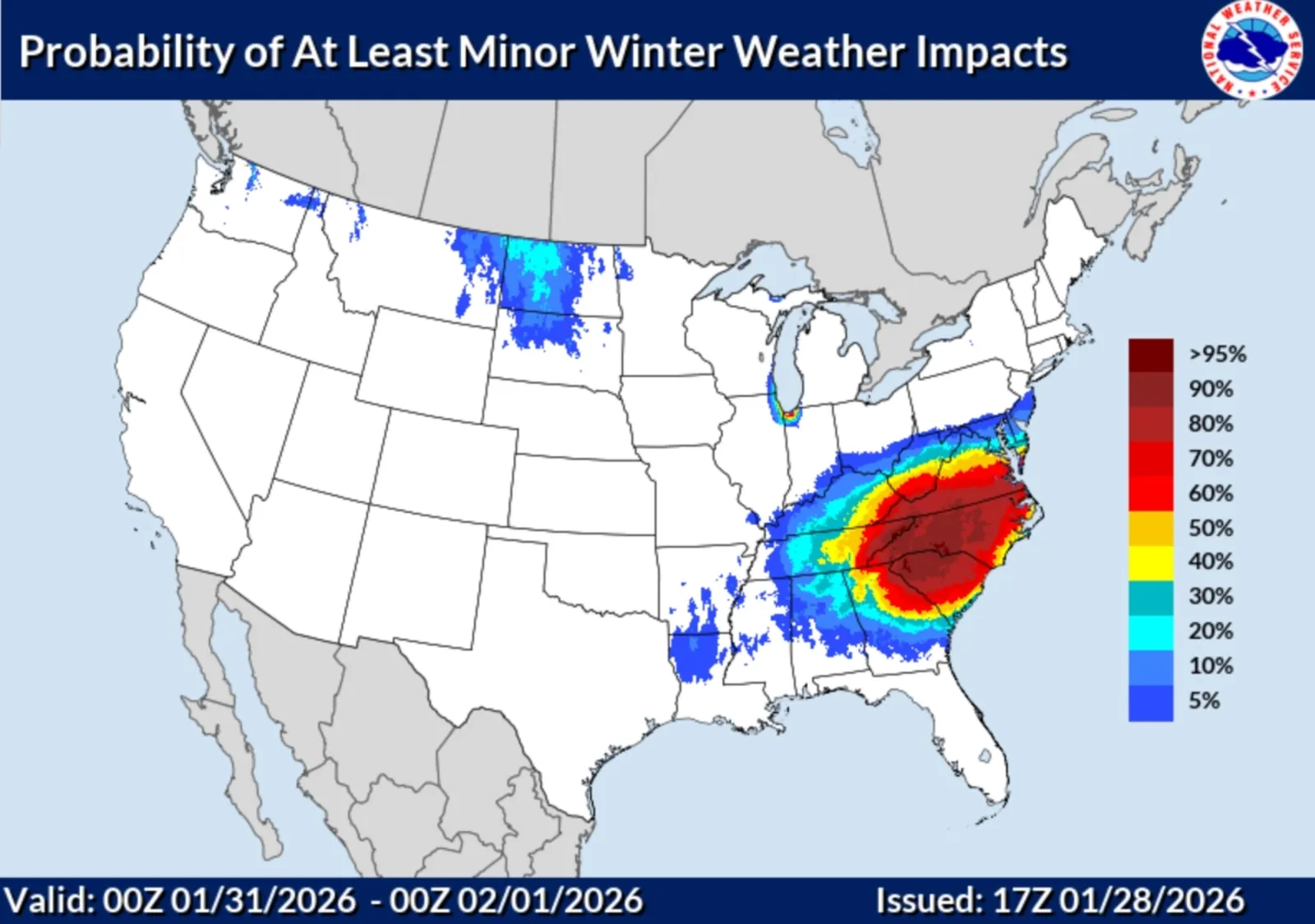
Saturday Winter Weather Impacts
The storm's impacts will ramp up on Saturday. Probabilities of experiencing at least minor winter weather impacts leap up to 95 percent in some areas, mostly South Carolina and North Carolina. A widespread high chance of impact from the system is also expected in eastern Tennessee, Kentucky, West Virginia, Virginia, North Carolina, South Carolina, and Georgia.
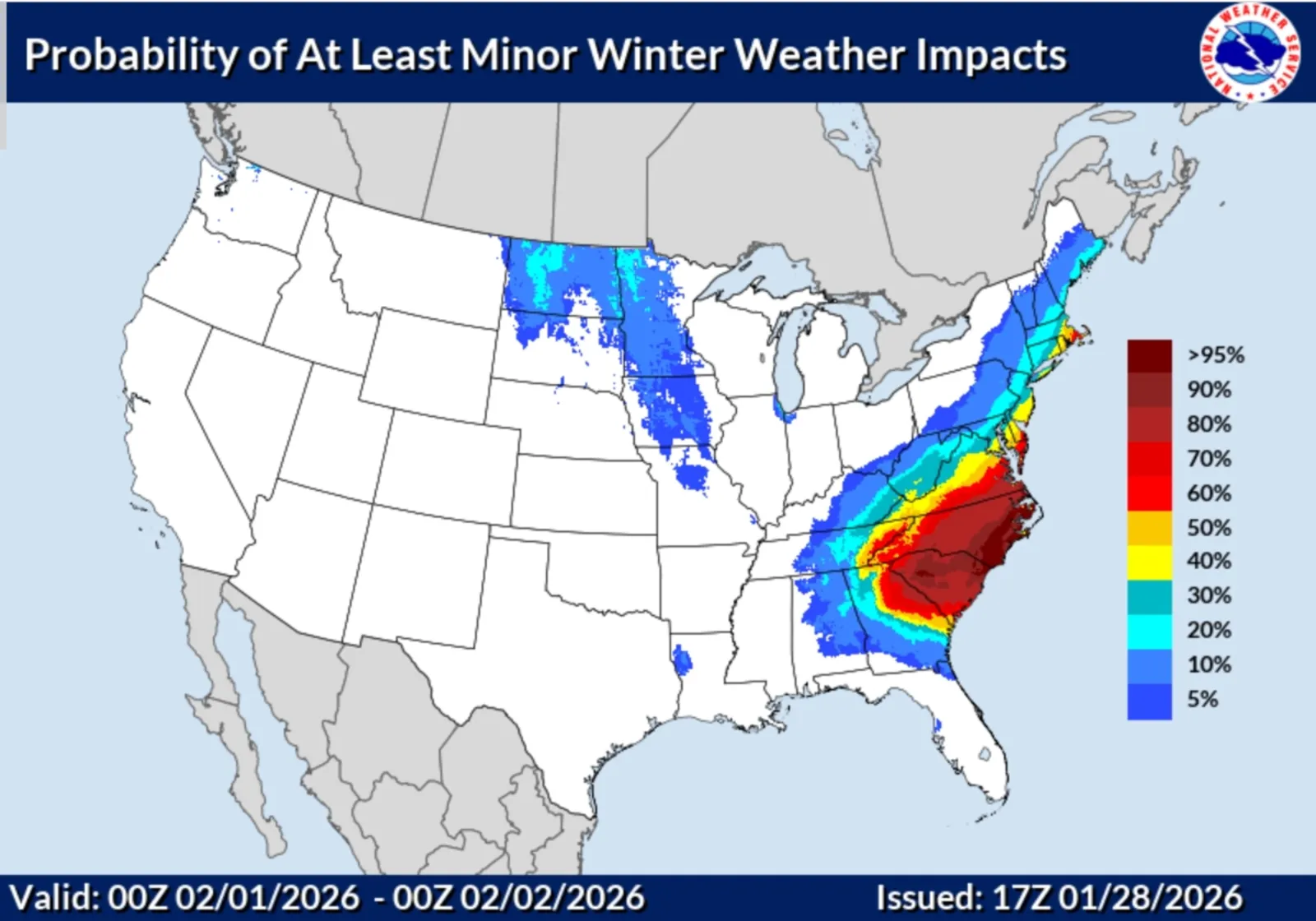
Sunday Winter Weather Impacts
On Sunday, the worst impacts will move further east along the coast before exiting the U.S. on Monday. A high chance of impacts is expected to persist in Tennessee, North Carolina, South Carolina, Georgia and Virginia. Maryland, Delaware, and Massachusetts also have a high chance of minor impacts.
By Monday, the worst of the storm looks as though it will have exited the U.S.
The storm's arrival is still days away, so no winter weather advisories or winter storm warnings have been issued as of Wednesday afternoon. However, NWS offices in the areas expecting impacts have started to issue hazardous weather outlooks warning of the incoming winter weather.
"Confidence is increasing for a winter storm to bring snow, gusty winds, and marine and coastal impacts to ENC this weekend," the NWS office in Morehead City, North Carolina, said in a hazardous weather outlook issued on Wednesday.
"There is an increasing risk for measurable snow across portions of north and central Georgia Friday night through Saturday night," NWS Peachtree City, Georgia, said in a hazardous weather outlook. "Confidence remains low on location/extent and potential amounts of snow."
"Confidence continues to increase for measurable snow in central NC Friday night into Sunday morning. Although considerable forecast uncertainty remains regarding amounts and related impacts, the potential exists for significant snow anywhere from the Carolinas into portions of the Middle Atlantic," NWS Raleigh, North Carolina, said in a similar message. "That increasing potential for snow will be accompanied by Arctic cold and a blustery wind that will produce multiple mornings of wind chill values in the single digits below zero to single digits above zero through the weekend."
View 0 Comments
Submit Correction
View Editorial & AI Guidelines