
By Joe Edwards
Reporter
0
Share
Newsweek is a Trust Project member
See more of our trusted coverage when you search.Prefer Newsweek on Googleto see more of our trusted coverage when you search.
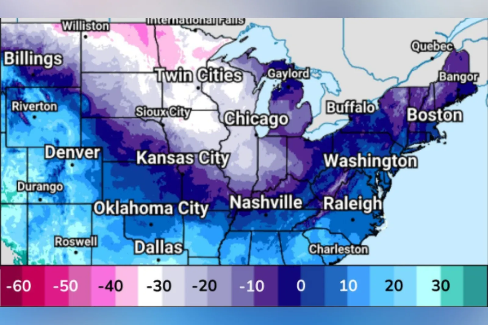
Arctic air is expected to bring “near record cold” along with “dangerous wind chills” as it tracks south from the Northern High Plains on Friday, spreading into the Central Plains and Ohio Valley on Saturday, then reaching the Mid-South and Mid-Atlantic on Sunday, according to forecasters at the National Weather Service (NWS).
Forecasters say that temperatures are expected to run as much as 20–30 degrees below normal, with the largest departures from the Northern High Plains to the Ohio Valley, where lows will plunge well below zero. Lows below 20 degrees are forecast to extend as far south as the northern Gulf states and as far east as the Mid-Atlantic, according to the Weather Prediction Center (WPC).
Read More on News
The agency says that this cold will be paired with gusty winds of 20–35 miles per hour, with the strongest across the Northern Plains. The mix of frigid temperatures and gusty winds will produce “dangerous” wind chills below 30 degrees in the Northern Plains and Upper Midwest Friday to Sunday, with sub-zero wind chills spreading across much of the Mid-Mississippi Valley and into the Ohio Valley and Central Appalachians, it said.
“These wind chills will post a life-threatening risk of hypothermia and frostbite to exposed skin,” the agency warned. “Have a cold weather survival kit if traveling. Act to protect outdoor animals and livestock from the cold,” the WPC advised.
As of early Friday, cold weather advisories from the NWS have been issued for much of Minnesota and Wisconsin, as well as parts of North Dakota and Michigan’s Upper Peninsula.
“There have been series of clipper lows in recent days tracking from central Canada across the Great Lakes to the East. Each has been followed by a blast of arctic air,” AccuWeather senior meteorologist Bob Larson told Newsweek.
“What appears to be the last storm in this given series will move through this weekend, spreading snow from the Dakotas through the Midwest to the East Saturday-Sunday. Another shot of arctic cold will follow, but indications are this might be the last arctic shot of the month,” Larson added.
The meteorologist said that Minneapolis is expected to reach 10 to 15 below zero Friday night and Saturday night, while the coldest air so far this season in the city has been five below.
Chicago will drop to zero to five below Saturday night, while St. Louis will come close to zero, Larson added.
Multiple icy blasts have been felt recently across parts of the U.S., associated with the polar vortex.
According to the NWS, the polar vortex is a broad region of low pressure and frigid air surrounding each of Earth’s poles. It is a year-round feature, though it weakens in summer and becomes more intense in winter. The word “vortex” refers to the counterclockwise circulation that helps confine this cold air near the poles. In many northern hemisphere winters, the polar vortex can stretch southward, allowing cold air to spill down with the jet stream. This is a fairly common winter pattern and is often linked to major Arctic cold outbreaks in the U.S., it says.
USPS Service Alert
The United States Postal Service (USPS) has issued an alert advising that wintry weather in the Northern Plains, Great Lakes, Ohio Valley and Northeastern U.S. “may impact the processing, transportation, and delivery of mail and packages.”
States among those facing the potential disruptions are Montana, North Dakota, South Dakota, Minnesota, Wisconsin, Iowa, Illinois, Indiana, Michigan, New York, Vermont, New Hampshire and Maine, according to the service.
View 0 Comments
Submit Correction
View Editorial & AI Guidelines