...

By Joe Edwards
Reporter
0
Share
Newsweek is a Trust Project member
See more of our trusted coverage when you search.Prefer Newsweek on Googleto see more of our trusted coverage when you search.
Minnesota residents are bracing for a potential major weather event Monday afternoon and evening, as meteorologists forecast the possibility of severe storms and dangerous tornadoes across much of the state.
Why It Matters
The National Weather Service has placed a large section of southeast Minnesota under a Level 4 risk (out of 5) for severe weather. Forecasters warn that residents could face powerful tornadoes, large hailstones, and damaging winds.
Read More on News
...
What To Know
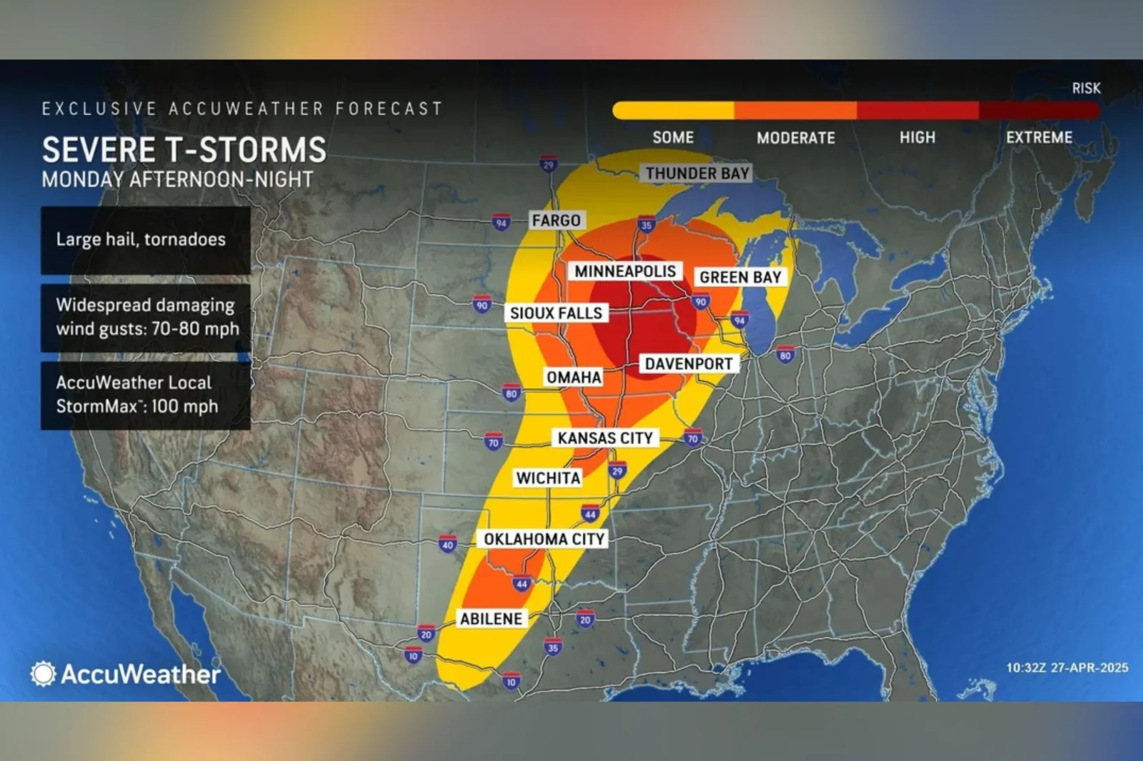
A major severe weather outbreak is forecast for Monday, stretching from Texas through the Plains and Midwest to Minnesota and Michigan's Upper Peninsula.
AccuWeather meteorologists identified a high risk for severe storms across parts of the Upper Midwest. The region faces multiple threats, including large hail, tornadoes, and widespread damaging wind gusts.
"Some of these tornadoes could be long-lived, posing an even greater risk, particularly those that develop after dark when they are more difficult to detect and prepare for," the outlet said in a media package provided to Newsweek.
Safety Tips for Severe Weather
Residents are urged to take action before the storms arrive. The City of Minneapolis offered several preparedness tips to help mitigate risk:
- Have multiple methods to receive weather alerts, including weather radios and mobile notifications.
- Be prepared to seek shelter immediately if a tornado warning is issued. A basement or an interior room without windows on the lowest floor is the safest option.
- Secure or bring inside outdoor furniture and other items that could become airborne during strong winds.
- Clear leaves and debris away from catch basins to help prevent localized street flooding during heavy rain.
- Prepare for power outages by charging mobile devices and keeping flashlights and batteries ready.

...
What Areas Are Most At Risk?
According to the National Weather Service Storm Prediction Center (SPC), southeast Minnesota faces the highest risk, with this part of the state falling under a Level 4.
Cities such as Minneapolis and Rochester were located in the highest risk area, a forecast map from AccuWeather showed.
Meanwhile, parts of neighboring Wisconsin and Iowa also fall under this category.
One of the most significant tornado events in Minnesota's recent history occurred on June 17, 2010, when 48 tornadoes touched down across the state in a single day—marking the largest tornado outbreak in Minnesota's history.
In recent years, the state has seen an uptick in severe weather activity outside the traditional tornado season. For instance, on August 29, 2024, six tornadoes were confirmed across central and southern Minnesota, including an EF1 tornado that tracked near Andover in Anoka County.
What People Are Saying
The National Weather Service (NWS) said on X: "Multiple corridors of severe thunderstorms are expected across the Upper Midwest on Monday into Monday night, with a regional severe weather outbreak possible. The most dangerous period is likely during the late afternoon and evening when strong tornado potential should be maximized. Scattered large to very large hail and damaging winds are likely as well."
NWS Twin Cities said on X: "Round 1 Monday morning has higher confidence in storms, but main threat is "only" large hail. Round 2 Monday afternoon/evening has lower confidence in where/when storms will develop, but IF they do, they could be bad. Main concern is strong tornadoes."
What Happens Next
According to an AccuWeather forecast shared with Newsweek, severe storm threats will persist from Tuesday into Tuesday night as the front pushes eastward. Cities including Dallas, St. Louis, Indianapolis, and Cleveland are in the path of potential storms. Any thunderstorms that develop could bring hazards such as hail, flash flooding, damaging wind gusts, and isolated tornadoes, the outlet said.
Correction 04/28/2025, 10:05 a.m. E.T: This article was updated to clarify that Iowa was in the highest risk area.
View 0 Comments
Submit Correction
View Editorial & AI Guidelines