10
Loading video...

By Anna Skinner
Associate News Editor
0
Share
Newsweek is a Trust Project member
See more of our trusted coverage when you search.Prefer Newsweek on Googleto see more of our trusted coverage when you search.
The developing super El Niño has already broken records for its strength, and it will only get stronger in the coming months, meaning that some major U.S. winter events could be impacted by the climate pattern.
The National Oceanic and Atmospheric Administration (NOAA) announced that El Niño had developed in the tropical Pacific in June. Ever since, the climate pattern has been strengthening and has already broken the record for the highest ocean anomaly in more than 170 years. El Niño is the warm phase of the El Niño-Southern Oscillation cycle. It occurs on average once every three to five years and forms when equatorial Pacific temperatures are .5 degrees Celsius above average for several months in a row.
A NOAA spokesperson previously told Newsweek that El Niño is expected to continue strengthening through November and December. Even after it begins to weaken, impacts are expected across the U.S., with the strongest impacts most typically affecting the U.S. between December and March, the spokesperson said.
Read More on Weather
This period encompasses a time with major events such as the Super Bowl, Mardi Gras, holiday events like the Macy's Thanksgiving Day Parade and the Rockefeller Center Christmas Tree Lighting—both in New York City—and more.

...
What Is Super El Niño?
Many independent meteorologists and other weather agencies have been referring to the current event as a super El Niño. Although the NOAA refers to the climate pattern as “very strong,” both labels refer to an event in which waters are warmer than average, usually by around 2 degrees Celsius.
The current El Niño has already surged past that number. The current El Niño is over 3 degrees Celsius above average and still climbing.
“Every El Niño is not the same; each one is unique with its own imprint on our weather,” NOAA's National Weather Service (NWS) Director Ken Graham said in June when NOAA announced the developing El Niño. "Advanced monitoring and an improved understanding of El Niño patterns allow the NWS to better predict and better prepare the public and our core partners for what is to come.”
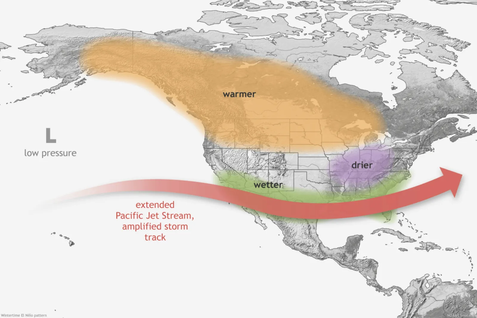
The warmer the waters, the greater the influence on weather. El Niño can influence weather around the globe. In the U.S., it causes the most widespread impacts during the fall and winter months, when cooler, wetter conditions are experienced across the South, with warmer, drier conditions in the North. It can also influence the storm track, whether precipitation falls as snow or rain, and extreme cold spells.
Related Story
Nor’easter, Polar Vortex, El Niño: Maps Show Which States Face Worst Impacts
What Major U.S. Winter Events Could Be Impacted?
One of the areas forecasters are monitoring as El Niño develops this winter is Southern California and the broader Southwest U.S. region. Strong El Niño patterns can alter storm tracks and bring more atmospheric rivers and heavy rainstorms to Southern California in the winter months.
This could pose an issue for Super Bowl LXI, set for February 14, 2027, at SoFi Stadium in Inglewood, California. SoFi Stadium is a covered, open-air stadium with a translucent roof, so it is less likely to be impacted by weather events such as rain, but it is not immune to weather delays or cancellations. Although the roof protects players and attendees from rain, heavy rain--such as that associated with an atmospheric river--could cause complications before and after the game with travel, parking and flooding concerns.
Lightning, which can also accompany an atmospheric river, would be cause for a delay. El Niño events can bring strong storms and atmospheric rivers laden with extreme moisture to the region, which could affect the Super Bowl if the forecast leans toward unfavorable weather.
Louisiana also falls into the part of the U.S. that typically sees more rain during the winter months, which could dampen Mardi Gras plans for people in New Orleans next year, as many celebrations occur outside. Mardi Gras will be February 9, 2027, although New Orleans' carnival season begins on January 6. Many Mardi Gras events, such as parades, parties and gatherings, occur outdoors.
"The Gulf Coast states are definitely going to be very stormy [this winter], so Mardi Gras could certainly be impacted," The Weather Channel principal weather producer Heather Zons told Newsweek, adding that the greatest threats could be rain, severe storms and flooding. The same threats could disrupt the Super Bowl.
Atmospheric rivers could pose a threat to Southern California in February. Zons said the weather pattern typically sets up for that region in January, and that storms lingering into February "would not be a surprise, especially during an El Niño."
NOAA forecasts also show that typical El Niño winters can mean colder temperatures in the South, including Louisiana.
Meanwhile, the Northeast will be facing the opposite issue. While El Niño tends to bring warmer winter temperatures to the northern U.S., that could take away from some of the magic during the Rockefeller Center Christmas Tree Lighting or New Year's Eve celebrations if there's no snow.
This year, the tree lighting is scheduled for December 2. AccuWeather senior meteorologist and long-range forecaster Chad Merrill told Newsweek that long-range forecasts currently show above-average temperatures for the tree lighting, with the chance of some rain showers.
"If there would be precipitation coming to New York, it would come as rain, and you wouldn't want a rainy Rockefeller tree lighting or a rainy New Year's Eve [in Times Square]," Zons said.
As for the Macy's Thanksgiving Day Parade on November 26, Merrill said breezy conditions and a chance of rain could be in place before warmer-than-average temperatures take hold in December.
Earlier in the season, El Niño could aid in longer-lasting fall colors across the Northeast, which is a popular destination for people wanting to see fall foliage. With El Niño potentially bringing a warmer fall to the region, fall foliage may stay in place longer than normal or pop with extra color this year.
What Is a Kelvin Wave?
The forecast and outlook for this coming winter comes as meteorologists monitor a Kelvin wave associated with the ongoing El Niño pattern. A Kelvin wave is a large-scale movement of warm ocean water. Changing trade winds brought by El Niño can cause the Kelvin wave.
One such wave could reach the West Coast within days. Should that happen, sea levels could rise, contributing to the risk of coastal flooding.
The Kelvin wave will increase sea levels, which means at high tide or during strong storms, coastal flooding and storm surge impacts could be even worse along the West Coast. The Kelvin waves can also cause beach erosion.
What Happens Next
Even as meteorologists and weather experts assess El Niño trends and anticipate how they might impact the coming U.S. winter, the exact forecast remains unknown. People taking part in outdoor celebrations this winter are encouraged to follow local forecasts and weather guidance as the event gets closer. Merrill said forecasts will be more accurate between two and three weeks out from an event.
El Niños typically last between nine and 12 months, although stronger events can last longer.
Contact Newsweek editors on this story: Anna Skinner and Dave Siminoff.
View 0 Comments
Submit Correction
View Editorial & AI Guidelines