

By Amanda Castro and Hannah Parry
0
Share
Newsweek is a Trust Project member
See more of our trusted coverage when you search.Prefer Newsweek on Googleto see more of our trusted coverage when you search.
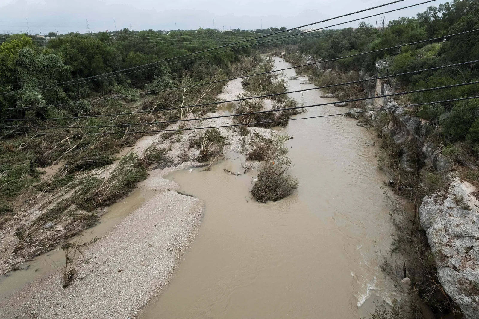
After a devastating holiday weekend that left dozens dead and many still missing, Central Texas is bracing for more rain. Harrowing images have captured the devastation left behind by the historic floods which downed trees, washed away homes and left roads underwater. Forecasters warn that additional storms this week could exacerbate already hazardous flood conditions, with saturated ground and swollen rivers leaving little room for further water accumulation. Emergency officials remain on high alert as the region faces the threat of renewed flash flooding.
What to Know:
- A new round of storms is expected to bring 2–4 inches of rain, with isolated totals up to 10 inches possible.
- The National Weather Service has extended flood watches across Central Texas through Monday evening.
- Areas hardest hit by the July 4 floods—including Kerr, Llano, and Bell counties—remain at high risk.
- Emergency crews are still conducting search and rescue operations for missing residents and campers.
- The Guadalupe River and other waterways remain dangerously elevated, with little capacity for runoff.
- Officials urge residents to avoid low-lying areas and heed all weather alerts and evacuation orders.
- The flooding has already become one of the deadliest in U.S. history, with at least 104 confirmed dead.
Newsweek's live blog is closed.
...
Jul 07, 2025 at 07:49 PM EDT
Texas flash flooding threat to continue into midweek
The risk of flash flooding is expected to remain in central Texas through until midweek, AccuWeather meteorologists warned.
Slow-moving storms will continue on Tuesday and Wednesday, bringing thunderstorms, heavy rain and flash floods, until it meets the Texas midsummer heat.
Dangerous flooding conditions remain on Monday evening as parts of central Texas are expected to receive a total of ten inches of rain, which is significantly less than the 20 inches than fell within a matter of hours on Friday.
Jul 07, 2025 at 07:20 PM EDT
Flooding reported in North Carolina after Tropical Depression Chantal made landfall
At least one person has died in North Carolina floods after Tropical Depression Chantal made landfall on Sunday.
The storm delivered around two months' worth of rain to Chapel Hill, Durham, and the surrounding area, closing roads, stranding residents and causing wide flooding.
At least 50 people were rescued overnight, with another 60 forced to evacuate by the rising floodwaters.
Sandra Portnoy Hirschman, 83, died after driving into floodwater in Chatham County, when her car was swept down the flooded road and submerged, the State Highway Patrol said.
Jul 07, 2025 at 06:47 PM EDT
Nearly 5,000 remain without power amid storms
Nearly 5,000 households in Texas remain without power as of 6.30 p.m. ET on Monday after the historic rainfall and flooding over the weekend.
Kerrville city manager Dalton Rice said that in his city, at least 40 power lines are still down after the storms. Teams are being brought in to repair them, he added.
According to PowerOutage.com, 4,926 are still in a blackout.
Jul 07, 2025 at 06:28 PM EDT
Around 5 million under flood watch, warnings
Flood watches, warnings or advisories remain in effect for about 5 million people in central and western Texas this afternoon.
They include residents in San Angelo, Killeen, Kerrville, San Antonio and Austin.
The watch will remain in effect until 7 p.m. with up to 10 inches possible, the National Weather Service said in an alert.
Residents are urged to take precautions as further flash flooding is possible.
Jul 07, 2025 at 06:04 PM EDT
Map shows where heavy rain, flash flooding forecast in Texas

Jul 07, 2025 at 05:50 PM EDT
IN PICTURES: Mexican firefighters transport a recovered body amid rescue efforts

...

...

...
Jul 07, 2025 at 05:37 PM EDT
Tropical Storm Chantal weakens to tropical depression
Tropical Storm Chantal, which formed off the coast of South Carolina over the weekend, has now weakened to a tropical depression.
The National Hurricane Center has now discontinued all tropical storm warnings and coastal advisories.
Jul 07, 2025 at 05:17 PM EDT
WATCH: Border czar Homan praises Trump’s Texas flooding response: ‘Thank God Biden is not president’
Jul 07, 2025 at 05:04 PM EDT
WATCH: Storm tracker shows weather pattern over Texas as rain forecast to continue
Jul 07, 2025 at 03:59 PM EDT
Hilly terrain funneled deadly floodwaters into Kerr County rivers
On the day deadly flash floods swept through Kerr County, the National Weather Service reported between 5 to 10 inches of rain falling in just 3 to 6 hours across the region—far exceeding early forecasts of 8 inches.
The area's steep, hilly terrain played a devastating role. Torrents of rainwater rushed off the slopes and into surrounding rivers, causing them to swell rapidly and overflow into low-lying communities. The Guadalupe River surged more than 26 feet in under an hour, turning into a deadly torrent that swept away homes, vehicles, and lives.
Kerr County's topography, combined with the seasonal risk of severe storms, has made it historically prone to flash flooding. But officials say this event was among the worst on record, with 94 confirmed deaths and dozens still missing.
Jul 07, 2025 at 03:47 PM EDT
Minor flooding expected in Southern Tom Green County after heavy rain
A Flood Advisory remains in effect for southern Tom Green County, Texas, until 5:45 p.m. CDT, as thunderstorms continue to dump heavy rain across the region. The National Weather Service in San Angelo issued the alert after radar detected rainfall totals between 0.5 and 1 inch, with an additional 1 to 2 inches expected to fall.
The advisory warns of minor flooding in low-lying areas and spots with poor drainage, particularly near Christoval. Residents are urged to avoid flooded roads and seek higher ground if necessary.
"Turn around, don't drown," officials cautioned, noting that most flood-related deaths occur in vehicles.
This advisory comes amid a broader flood emergency across central Texas, where dozens have died and hundreds have been rescued following catastrophic rainfall over the holiday weekend.
Jul 07, 2025 at 03:34 PM EDT
How much rain fell in Texas?
Parts of Texas received more than 20 inches of rain over the weekend, which triggered the devastating flooding that left dozens dead.
Data shows that over the holiday weekend, the city of Bertram, north of Austin, received over 20 inches of rainfall, between Thursday and Morning morning.
Other central Texas cities, such as Liberty Hill and Streeter also saw more than 20 inches of rain, according to the National Weather Service's Prediction Center. The nearby Marble Falls received 18.5 inches.
Meanwhile, Austin received almost 9 inches of rain.
Jul 07, 2025 at 02:50 PM EDT
New urgent flood warning issued for three Texas counties
The National Weather Service has issued a new flood warning for three Texas counties, south of Waco.
The warning is issue for Bell, Coryell and Lampasas counties, from 11.09 a.m. CDT to 2 p.m. CDT.
Numerous roads are closed in the areas after another five inches of rain fell on the saturated ground.
The NWS added that the flood water could take "several hours to recede" and urged drivers to "turn around, don't drown when encountering flooded roads."
"Most flood deaths occur in vehicles," it added.
Jul 07, 2025 at 02:45 PM EDT
WATCH: Texas resident describes horror of deadly flash floods
Jul 07, 2025 at 02:30 PM EDT
Texas Hill Country is dubbed ‘flash flood alley’ for its frequent flooding
One of the hard-hit areas, Texas Hill Country, is dubbed "flash flood alley" due to its frequent floods.
The region covers many major cities such as s San Antonio, Dallas, Austin and Waco.
"The flooding was certainly extreme but it should not have been historically unexpected," said Roger Pielke, Jr., a political scientist, told USA Today. "The documented record of extreme flooding in 'flash flood alley' goes back several centuries."
Jul 07, 2025 at 02:03 PM EDT
Texas death toll rises to 91, the White House confirms
At least 91 people have now died in the devastating flooding in Texas, White House Press Karoline Leavitt said on Monday.
Dozens more remain unaccounted for.
Jul 07, 2025 at 02:03 PM EDT
WATCH: Texas residents reeling after devastating floods: ‘Everything’s soaked’
Jul 07, 2025 at 01:47 PM EDT
How did the Texas flooding happen?
The devastating Texas flooding was caused by a combination of factors including "unprecedented" heavy rainfall across the central and western parts of the state, combined with rocky terrain and saturated rivers.
The main factors include:
Prolonged and Repetitive Thunderstorms
Over several days starting in the early hours of Friday morning, a stalled weather pattern brought persistent thunderstorms to the region. These storms focused on the same areas in a phenomenon known as "training," where storm cells follow one another like train cars on a track. This led to repeated downpours over already saturated ground.
- Some areas, such as Kerr and Llano Counties, saw rainfall totals exceed 10 inches within hours.
- Localized flash floods became widespread because the soil couldn't absorb the rapidly falling rain.
Terrain and Hydrology
The region hardest hit — the Texas Hill Country — is particularly vulnerable to flash flooding due to its rugged terrain and shallow soil:
- Steep slopes and limestone bedrock cause water to run off quickly instead of soaking into the ground.
- Rivers like the Guadalupe and Llano rose rapidly, in some cases by more than 25 feet in under an hour, overwhelming riverbanks and flood control systems.
- Low-water crossings and small creeks became raging torrents, sweeping away roads, cabins, and vehicles.
Saturated Ground and Infrastructure Vulnerability
Prior rainfall in the weeks leading up to the event had already saturated the soil in many areas. When intense rains began:
- Urban runoff intensified due to paved surfaces in cities like Austin and Killeen, contributing to street and highway flooding.
- Drainage systems were overwhelmed, especially in rural and semi-rural areas, causing water to back up into homes and businesses.
Limited Warning Time and Rapid Onset
Many of the flash floods happened very quickly, often within minutes of rainfall intensifying. Despite warnings from the National Weather Service, the speed and severity of the floodwaters took many by surprise:
- At Camp Mystic in Kerr County, for example, cabins were swept away with little time to evacuate.
- Emergency responders were forced into large-scale search and rescue operations, including air rescues.
Jul 07, 2025 at 01:36 PM EDT
IN PICTURES: Harrowing images show aftermath of floods

...
...

...

...

...

...
Jul 07, 2025 at 01:12 PM EDT
What cities in Texas have flooded since Friday?
Dozens of cities in Texas have experienced flooding since the historic downpours across the state on Friday.
Kerr County:
- Kerrville
- Hunt
- Ingram
These cities were among the hardest hit. The Guadalupe River rapidly rose by over 26 feet, flooding Camp Mystic near Hunt and Ingram. Kerrville saw massive search and rescue efforts, with at least 75 fatalities reported in the area, including 27 children.
Austin and Travis County:
- Austin
- Jonestown
Austin experienced flash floods that led to at least three fatalities and multiple water rescues. The Highland Lakes and nearby creeks saw dangerous overflow, prompting emergency alerts and urging residents to avoid water bodies.
Burnet and Llano Counties:
- Burnet
- Llano
- Tow
- Lake Victor
- Buchanan Lake Village
- Castell
- Valley Spring
- Baby Head
- Oxford
These cities faced both flash flooding and river flooding. Multiple deaths were reported, and evacuations were necessary. Rural roads and low-water crossings were especially hazardous.
Other Cities in Central Texas
- Brady (McCulloch County)
- Camp San Saba
- Voca
- Calf Creek
- Center City (Mills County)
- Caradan
- Pecan Wells
- Star
- Moline
- Lampasas (Lampasas County)
- Copperas Cove
- Killeen
- Fort Cavazos
- Kempner
These towns and cities reported flash flood warnings and significant rainfall, with roads submerged and vehicles stranded. Radar and emergency sources confirmed life-threatening flooding in several of these locations.
Jul 07, 2025 at 01:07 PM EDT
Flood threat upgraded in central Texas
The risk level for flooding in central Texas has been upgraded from a level 2 to a level 3, on a 1-4 scale.
The Weather Prediction Center upgraded the risk level after further heavy rain is predicted in saturated areas that were already hard hit by flooding.
They include parts of Kerr County and portions of the Guadalupe and Llano river basins.
"Any storms that move across this extremely vulnerable region will rapidly cause flash flooding, some of which could be significant if (storms) repeat or stall over the already hard-hit regions," the center warned.
Jul 07, 2025 at 12:58 PM EDT
Thousands of Texans remain without power amid historic floods
More than 6,000 households in Texas remain without power on Monday after the historic rainfall and flooding over the weekend.
Kerrville city manager Dalton Rice said that in his city, at least 40 power lines are still down after the storms. Teams are being brought in to repair them, he added.
According to PowerOutage.com as of 12.55 p.m. ET around 6,212 were still in the dark.
Jul 07, 2025 at 12:34 PM EDT
Up to ten inches of rain expected to fall on central Texas
Up to ten inches of rain is expected to fall on certain parts of central Texas, the National Weather Service (NWS) said in a warning on Monday.
"Flooding caused by excessive rainfall is possible... Excessive runoff may result in flooding of rivers, creeks, streams, and other low-lying and flood-prone location," the service said.
Affected areas for the heaviest rainfall include the following counties; Bandera, Bastrop, Bexar, Blanco, Burnet, Caldwell, Comal, Edwards, Gillespie, Guadalupe, Hays, Kendall, Kerr, Lee, Llano, Medina, Real, Travis, Uvalde and Williamson.
Rainfall is expected between two and four inches "with 10 inches possible, said NWS.
Jul 07, 2025 at 12:30 PM EDT
Llano River expected to rise today
Llano River, northwest of the Texan city of Austin, is expected to rise today amid continuing heavy rainfall.
The river is not expected to reach the extreme levels it did on Friday, but it is expected to break its banks and read the minor to moderate flood stage of around 12 feet by Monday evening, according to NOAA.
The height would be less than half of what the river crested on Friday, at around 26.5 feet.
Rescue teams and people in the area are urged to take precautions during the clean up.
Jul 07, 2025 at 12:12 PM EDT
IN PICTURES: Map shows Texas counties under flood warnings

...
Jul 07, 2025 at 11:55 AM EDT
More than 2 million Texans remain under flood watch or warnings
Much of central Texas remained under a flood watch Monday, with certain areas elevated to a flood warning or advisory.
The residents of San Antonio, Austin and the surrounding areas have been urged to monitor forecasts, be alert for possible Flood Warnings and be prepared to evacuated if necessary.
Jul 07, 2025 at 11:49 AM EDT
Texas remains under multiple flood warnings
Heavy thunderstorms prompted multiple flash flood warnings throughout central Texas, including areas in Bell, Coryell, Lampasas, Burnet, Llano, McCulloch, and Mills counties.
The National Weather Service (NWS) in Fort Worth, San Angelo, and Austin/San Antonio issued these alerts, warning residents of significant rainfall accumulation ranging from 1.5 to 5 inches in several locations. Flash flooding was confirmed in numerous areas, with reports of stranded vehicles and closed roadways.
West Central Bell County and surrounding areas were among the hardest hit, with flash flooding already occurring as of 9:46 AM CDT. Emergency management sources confirmed flooded roadways, and residents in locations such as Killeen, Copperas Cove, Fort Cavazos, and Kempner were advised to avoid travel. Similar threats extended into southeastern Lampasas and southwestern Coryell counties, where additional rainfall was forecast, further aggravating flooding conditions.
In other parts of the region, including Llano and Burnet counties, radar detected intense storms producing rainfall rates of 1 to 3 inches per hour. The NWS reported considerable threats of life-threatening flash flooding in urban areas, highways, and streams. Flash flooding was ongoing or imminent in towns such as Llano, Buchanan Lake Village, and Lake Victor, with warnings to seek higher ground immediately and avoid low-lying routes.
Meanwhile, southeastern Mills County and northern Lampasas County experienced up to 3 inches of rainfall with the potential for another 3 to 5 inches. Radar also indicated dangerous conditions in southern McCulloch County, including towns like Brady and Camp San Saba. Across all affected regions, the NWS urged caution, stressing the danger of attempting to cross flooded roads and highlighting the common risk of flood-related fatalities in vehicles.
Jul 07, 2025 at 11:32 AM EDT
Tracker map shows tropical storm sweeping over state
View 0 Comments
Submit Correction
View Editorial & AI Guidelines