


By Amanda Castro, Hannah Parry, and Anna Commander
0
Share
Newsweek is a Trust Project member
See more of our trusted coverage when you search.Prefer Newsweek on Googleto see more of our trusted coverage when you search.
Tropical Storm Erin is forecast to become the first major hurricane of the 2025 Atlantic season, with sustained winds potentially reaching Category 3 strength by Sunday. While the storm is expected to pass north of Puerto Rico and the U.S. Virgin Islands, AccuWeather forecasters warn of heavy rain, strong wind gusts, and dangerous surf across the northeast Caribbean and along the U.S. East Coast.
What to Know:
- Erin formed Monday in the eastern Atlantic and is moving west at 22 mph
- The storm is expected to become a hurricane by Thursday and a major hurricane by Sunday
- Puerto Rico and nearby islands could see 1–2 inches of rain, with localized totals up to 7 inches
- Wind gusts may reach 40–60 mph across northern Puerto Rico, with isolated gusts near 80 mph
- Rough surf and rip currents are expected from Florida to New England starting this weekend
- Erin's long-term track remains uncertain, but most models show a northward turn away from the U.S.
This live blog is now closed.
Aug 15, 2025 at 11:57 AM EDT
Coverage on this live blog has moved
Newsweek's coverage of this live blog has moved. Tune in.
Hurricane Erin Live Updates: Category 4 Strength Forecast for Atlantic Cyclone - Newsweek
Aug 13, 2025 at 10:30 AM EDT
Satellites track Tropical Storm Erin as it nears hurricane strength
Tropical Storm Erin is gaining strength over the Atlantic Ocean, with satellite imagery showing signs of intensifying convection and increasingly organized cloud bands. The system, which originated from a tropical wave off Africa on Aug. 11, is forecast to become the first hurricane of the 2025 Atlantic season by late Thursday or early Friday.
Infrared data from NOAA's GOES-19 satellite reveal colder cloud tops and a tightening circulation—key indicators of a strengthening storm. Erin is currently moving westward from the Cabo Verde Islands at 20 mph, feeding on warm ocean waters that support rapid intensification.
Forecast models suggest Erin will curve northwest over the weekend, potentially passing near Puerto Rico, the Virgin Islands, and the northern Leeward Islands. While landfall is not expected, the storm may still bring heavy rain, gusty winds, and dangerous surf to parts of the U.S. East Coast as it moves northward.
NOAA's seasonal outlook remains unchanged, predicting an above-average hurricane season with up to 18 named storms. Erin's development underscores the importance of satellite monitoring in tracking storm evolution and improving forecast accuracy.
Aug 13, 2025 at 10:09 AM EDT
Tropical Storm Erin update as path shifts south
...
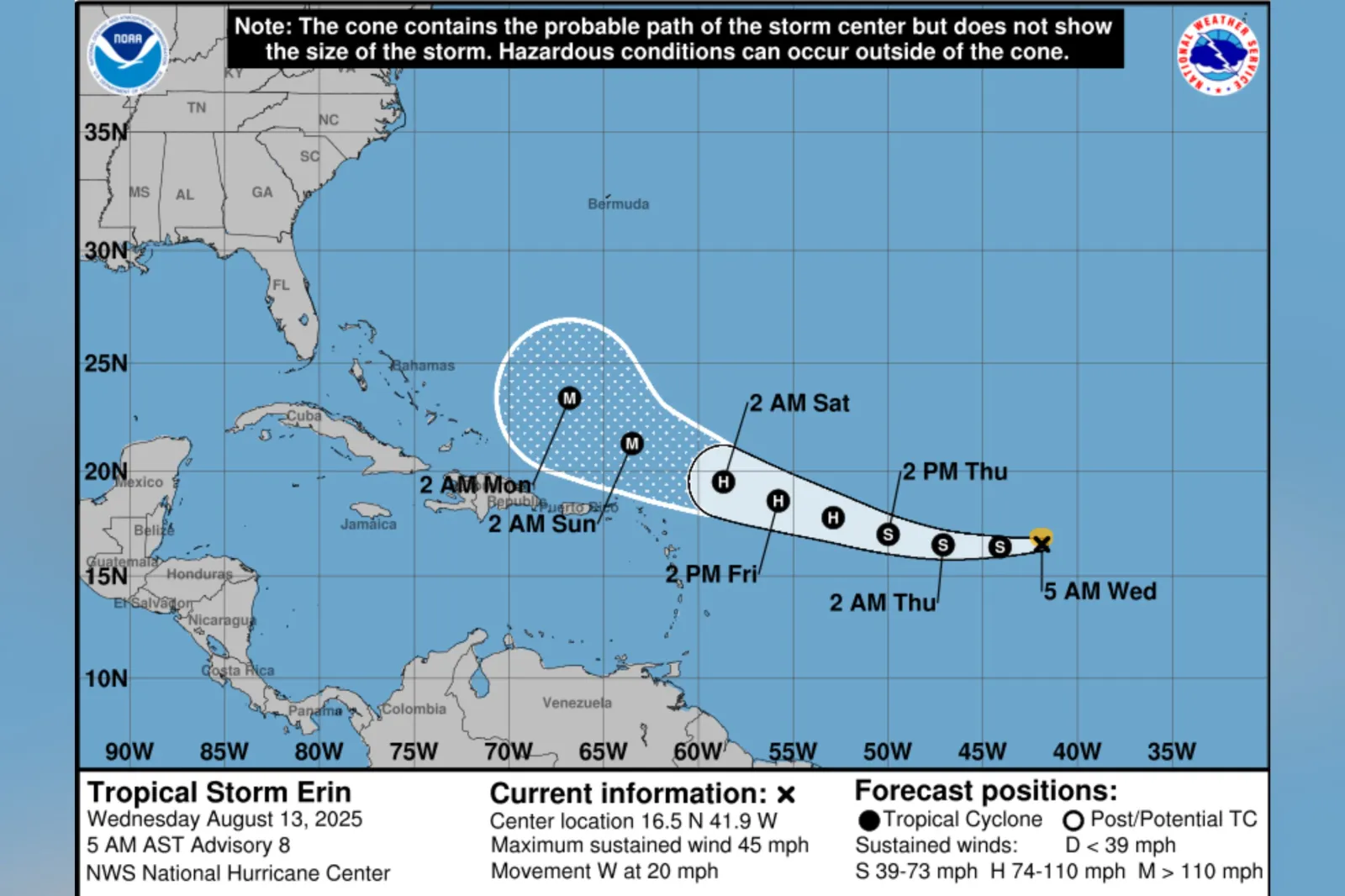
The National Hurricane Center (NHC) has warned that Tropical Storm Erin could move, causing impacts to Puerto Rico, the Virgin Island and the northern Leeward Island over the weekend, though the agency said the magnitude of any potential impacts was unclear.
Meteorologists have indicated that Erin has the potential to become the first major hurricane of the 2025 season.
Eris is the fifth named system of the Atlantic season so far, following Andrea, Barry, Chantal, and Dexter. Chantal brought heavy rain and flooding to North Carolina in early July.
None of the previous named storms developed into hurricanes.
Read the full story by Joe Edwards on Newsweek.
Aug 13, 2025 at 09:53 AM EDT
Tropical Storm Erin could bring impacts to Puerto Rico and nearby islands
Tropical Storm Erin continues to move west across the central Atlantic, and forecasters say it could pass close enough to Puerto Rico, the Virgin Islands, and the northern Leeward Islands this weekend to produce tropical storm conditions.
Aug 13, 2025 at 09:33 AM EDT
How hurricanes form and intensify: A look at tropical cyclones
Hurricanes, typhoons, and tropical cyclones are all names for the same weather phenomenon: a rotating, low-pressure system with organized thunderstorm activity that forms over warm tropical or subtropical waters. These systems draw energy from the ocean's heat and moisture, fueling their development and intensity.
Meteorologists classify tropical cyclones by wind speed:
- Tropical depression: winds less than 39 mph
- Tropical storm: winds between 39–73 mph
- Hurricane: winds of 74 mph or higher
- Major hurricane: winds of 111 mph or more
As a storm strengthens, it becomes more "organized," meaning its thunderstorms begin to wrap around a central point, forming distinct bands. This structure signals the development of a closed circulation—winds rotating continuously around a center. In the Northern Hemisphere, this rotation is counterclockwise; in the Southern Hemisphere, it's clockwise.
The hallmark of a mature hurricane is its eye—a calm, clear center surrounded by the eyewall, where the most intense winds occur. Satellite imagery often reveals this structure as storms intensify, as seen in past hurricanes like Ian and Michael.
These powerful systems can produce destructive winds, torrential rain, and coastal flooding. Their formation depends on a combination of warm ocean temperatures, moist air, and minimal wind shear. When these conditions align, tropical cyclones can rapidly escalate into major hurricanes capable of widespread damage.
Aug 13, 2025 at 09:16 AM EDT
National Hurricane Center issues updates as Tropical Storm Erin strengthens
The National Hurricane Center (NHC) continues to issue advisories for Tropical Storm Erin, which is steadily intensifying over the central Atlantic. As of Wednesday morning, Erin was located at 16.5°N and 41.9°W, moving west at 20 mph with sustained winds of 45 mph.
Marine warnings are in effect across the Atlantic, and forecasters expect Erin to reach hurricane strength by late Thursday. The storm could approach the northern Leeward Islands, Virgin Islands, and Puerto Rico over the weekend, though its exact impacts remain uncertain.
Aug 13, 2025 at 09:01 AM EDT
WATCH: Has Trump doomed FEMA for the hurricane season?
Aug 13, 2025 at 08:41 AM EDT
Tropical Storm Erin forecast to become hurricane, may near Caribbean islands
Tropical Storm Erin is expected to intensify into a hurricane by late Thursday or early Friday as it tracks west across the central Atlantic, according to the National Hurricane Center. The system, currently packing winds of 45 mph, is moving at 20 mph and could become the season's first major hurricane by the weekend.
Forecasters say Erin may pass near the northern Leeward Islands, the Virgin Islands, and Puerto Rico over the weekend. While the exact severity of impacts remains uncertain, residents in those areas are advised to monitor updates closely.
Beyond the Caribbean, Erin's future path is less clear. Forecast models suggest a possible turn to the northwest, which could steer the storm toward the Greater Antilles, the Bahamas, Bermuda, or even near the U.S. East Coast. However, most projections currently show the storm staying offshore.
Meteorologists caution that long-range forecasts are subject to change and emphasize the importance of preparedness as Erin continues to strengthen.
Aug 13, 2025 at 08:28 AM EDT
Hurricanes and typhoons: Same storm, different name
Hurricanes and typhoons are regional names for the same powerful weather system: a tropical cyclone. This term describes a rotating, organized system of thunderstorms and clouds that forms over warm tropical or subtropical waters and features a closed low-level circulation.
Tropical cyclones are classified by wind speed. The weakest are tropical depressions, with winds below 39 mph. Once sustained winds reach 39 mph, the system becomes a tropical storm. At 74 mph or higher, it is designated a hurricane, typhoon, or simply tropical cyclone—depending on its location.
- In the North Atlantic, central and eastern North Pacific, the term hurricane is used.
- In the Northwest Pacific, the same system is called a typhoon.
- In the South Pacific and Indian Ocean, it remains a tropical cyclone, regardless of strength.
Formation requires a pre-existing disturbance, warm ocean waters, moisture, and light upper-level winds. When these ingredients align, the result can be violent winds, heavy rain, and coastal flooding.
In the Atlantic, hurricane season officially runs from June 1 to November 30, though storms can form outside this window. Nearly all tropical cyclone activity—97 percent—occurs during this six-month period.
Aug 13, 2025 at 08:15 AM EDT
Understanding hurricane watches and warnings: What they mean and when to act

...
As the Atlantic hurricane season intensifies, knowing the difference between a hurricane watch and a hurricane warning is critical for safety and preparedness.
A hurricane warning means hurricane conditions—sustained winds of 74 mph or higher—are expected within a specified area. Because preparations become dangerous once winds reach tropical storm strength (39–73 mph), warnings are issued 36 hours before those winds are expected to arrive. During a warning, residents should complete all storm preparations and evacuate immediately if instructed by local officials.
A hurricane watch, on the other hand, signals that hurricane conditions are possible within the area. Watches are issued 48 hours ahead of the anticipated arrival of tropical-storm-force winds. This is the time to prepare your home, review evacuation plans, and stay closely tuned to updates from emergency management.
With several systems active in the Atlantic and forecasts calling for an above-normal season, officials urge residents in vulnerable areas to stay informed and act early.
Aug 13, 2025 at 08:00 AM EDT
How to prepare for a hurricane
The Disaster Preparedness Program, launched in 2018, coordinates training, exercises, and continuity planning across NOAA to ensure swift recovery after storms. It builds on the work of the Disaster Response Center in Mobile, Alabama, and supports emergency responders nationwide.
Real-time water-level monitoring is a cornerstone of NOS operations. Tools like the Inundation Dashboard and Storm QuickLook provide live data from over 200 observation stations, helping officials anticipate flooding and storm surge impacts. These systems integrate forecasts from the National Weather Service and historical flood data to guide local decision-making.
After landfall, NOS deploys Navigation Response Teams to survey ports and waterways for hazards. Using sonar and autonomous vessels, they help reopen shipping lanes and update nautical charts. Aerial imagery collected by the National Geodetic Survey supports damage assessments and search-and-rescue efforts.
Pollution response is also critical. The Office of Response and Restoration tracks hazardous spills, assesses environmental damage, and guides cleanup operations. Its ERMA mapping tool combines weather, ocean, and pollution data to support emergency managers.
Aug 13, 2025 at 07:45 AM EDT
Tropical Storm Erin expected to strengthen into major hurricane
Tropical Storm Erin was located at 16.5°N and 41.9°W early Wednesday, with sustained winds of 45 mph and a westward motion of 20 mph. Forecasters say the system is gradually regaining strength and could intensify significantly over the next few days.
Meteorologist Dave Osterberg noted that Erin is beginning to rebuild its convection, though Saharan dust in the region has limited its development. That may change soon, as the storm moves into warmer Atlantic waters.
If current trends hold, Erin could become the season's first Atlantic hurricane by late this week and reach Category 3 strength north of Puerto Rico over the weekend. Osterberg said the islands may see dangerous surf and rip currents but are unlikely to face direct impacts if the storm stays on its projected path.
Forecast models suggest Erin will turn north next week, staying east of the U.S. coastline. Two high-pressure systems—one over the Atlantic and another over the Southeast—are expected to steer the storm between them, keeping it offshore.
Still, forecasters caution that the exact track remains uncertain. Impacts to the Bahamas or the East Coast will depend on where Erin makes its anticipated turn. Until then, officials advise monitoring updates closely.
Aug 13, 2025 at 07:31 AM EDT
Heavy rain, fire danger and severe storms threaten multiple U.S. regions
Amid the developments occurring with Tropical Storm Erin, a volatile mix of weather hazards is unfolding across the U.S. on Wednesday, with flooding, fire risk and severe thunderstorms all in play.
In the southern Appalachians, forecasters warn that heavy to excessive rainfall could trigger flash flooding through midweek. Saturated soils and slow-moving storms may lead to dangerous runoff in valleys and low-lying areas.
Meanwhile, gusty winds and low humidity are creating critical fire weather conditions across the Great Basin and northern Rockies. Drought-stressed vegetation and dry air are fueling elevated wildfire potential, especially in parts of Montana, Utah and Idaho.
Farther north, the Storm Prediction Center has flagged portions of the northern Plains for severe thunderstorms. Areas from the Dakotas to Minnesota face threats of large hail, damaging winds, and isolated tornadoes as a cold front sweeps through the region.
Aug 13, 2025 at 07:09 AM EDT
Tropical storm Erin races west as Atlantic activity picks up: What to know
Tropical Storm Erin was rapidly moving west on Wednesday, two days after forming near the African coast. It is the fifth named system of the Atlantic hurricane season, which forecasters say could be unusually active.
No coastal warnings or watches have been issued, with Erin still far out at sea. However, meteorologists caution that its trajectory and strength could shift in the coming days.
The Atlantic basin is showing signs of increased activity after a quiet start. Two other systems are being monitored, though neither is expected to develop into a named storm under current conditions.
The National Oceanic and Atmospheric Administration projects up to 18 named storms this season—above the average of 14. The season runs through November.
Meanwhile, staffing cuts at federal agencies like NOAA, the National Weather Service and FEMA have raised concerns about forecasting capacity. The Weather Service may soon resume hiring, but the long-term impact of reduced personnel remains unclear.
Aug 12, 2025 at 07:46 PM EDT
NWS warns Puerto Rico, Virgin Islands may be impacted by Erin
The National Weather Service (NWS) has warned that Tropical Storm Erin may move close enough to Puerto Rico and the Virgin Islands this weekend to "produce some impacts on those islands."
NWS said the scale of the impact was not yet known and urged local officials to carefully monitor the progress of this storm
"There is an even greater uncertainty in which impacts might occur in portions of the Greater Antilles, the Bahamas, the East Coast of the United Staes, and Bermuda next week," NWS said in a post on X. "As we approach the climatological peal of the hurricane season, this is an opportune time to ensure your preparedness plans are in place."
Aug 12, 2025 at 07:30 PM EDT
Erin moving westwards across Atlantic faster than 97 percent of similar storms
Tropical Storm Erin is moving westwards across the Atlantic Ocean, towards the north of the Caribbean, faster than 97 percent of similar storms, according to a hurricane expert.
"Erin has been sailing along at about 23 mph, a very fast clip for a named storm in this part of the Atlantic (top 3%)," Michael Lowry, hurricane specialist and storm surge expert WPLGLocal10, said on X.
"The fast westward movement means tropical storm winds are limited to north the center. Tough for a hurricane to form at that speed, but it'll slow down soon."
Aug 12, 2025 at 07:10 PM EDT
Tropical storm-force wind speed map from NOAA

...
Aug 12, 2025 at 06:48 PM EDT
Tropical Storm Erin spaghetti models as storm path shifts
Tropical Storm Erin's path has changed slightly, prompting concern that the storm is heading toward the United States even as National Hurricane Center (NHC) experts said it's still too soon to tell what impacts, if any, Erin will cause.
Most spaghetti models, or computer models that illustrate potential storm paths, still show the storm taking a northward turn. However, the storm's path has shifted south, meaning some of its impacts could reach land, including the U.S.
"I still think the most likely scenario is a track somewhere between the Outer Banks [of North Carolina] and Bermuda," AccuWeather Lead Hurricane Expert Alex DaSilva told Newsweek. "However, due to the fact that this storm has been moving a little further south and west, that can certainly increase the chance it can come closer to the United States."
Erin could become a major hurricane, a designation that occurs when a storm's wind speeds reach 111 mph or higher, classified as Category 3. Should it strengthen as meteorologists expect, Erin could become not only the first hurricane but also the first major hurricane of the season.
Read in full from Anna Skinner on Newsweek.
Aug 12, 2025 at 06:30 PM EDT
WATCH: Tropical Storm Erin could become season’s first hurricane
Aug 12, 2025 at 06:20 PM EDT
When is the Atlantic hurricane season?
The Atlantic hurricane season began on June 1 and runs through November 30.
Tropical Storm Erin is the fifth named storm of the season and the second to form this month, following Tropical Storm Dexter, which fizzled out over the ocean in the first week of August.
Aug 12, 2025 at 06:07 PM EDT
Tropical Storm Erin update as chances of US landfall increase
A National Hurricane Center (NHC) forecast warned that Tropical Storm Erin is expected to strengthen into a hurricane in the coming days as it treks westward across the Atlantic Ocean as the chances of a U.S. landfall have increased slightly.
Tropical Storm Erin formed on Monday morning. Meteorologists had been tracking the storm, which originated as a tropical wave off the western coast of Africa, for days. As of Tuesday morning, Erin's maximum sustained windspeeds were measured at 45 mph, with stronger gusts.
A forecast map from the NHC anticipates the storm will become a hurricane by Thursday morning. Further strengthening is expected, with Erin intensifying into a major hurricane by late Saturday morning. A major hurricane forms once the hurricane becomes a Category 3 storm, in which windspeeds are measured at 111 mph or greater.
Shortly after Erin formed on Monday, Max Velocity, a meteorologist with 1.3 million subscribers on YouTube, shared the NHC forecast map in a post on X, formerly Twitter.
Read in full from Anna Skinner on Newsweek.
Aug 12, 2025 at 05:56 PM EDT
Hurricane Erin expected to reach wind speeds of up to 115 mph
Tropical Storm Erin is expected to reach wind speeds of up to 115 mph after it intensifies into a hurricane at the end of the week.
James Spann, a meteorologist, said that Erin currently has winds of 45 mph and is moving westwards at 20 mph.
"No change in the forecast thinking; Erin becomes a hurricane later this week; it will pass north of the Leeward Islands and Puerto Rico, and then turn north into the open Atlantic most likely before reaching the Bahamas," he said.
He added that the rest of the Atlantic basin was quiet with no tropical storms or hurricanes expected near the Gulf for the next week.
Aug 12, 2025 at 05:27 PM EDT
Map shows arrival times for tropical storm-force winds in Puerto Rico, Dominican Republic

...
Aug 12, 2025 at 04:55 PM EDT
Expert says Tropical Storm Erin’s recent evolution has left weather models ‘confused’
Tropical Strom Erin appeared to weaken on Tuesday as it met Saharan dust clouds and colder ocean temperatures.
However, Weather Track U.S. said its "recent evolution" has left "model guidance quite confused, with a large spread in the intensity guidance."
"Even some of the new hurricane guidance, like the HAFS keeps Erin as a Tropical Storm.
"This weaker guidance is most likely unrealistic, and once Erin can regain deep convection over her center, model guidance should come into better agreement, with a Hurricane (or Major Hurricane) back in the forecast from majority of the reliable guidance," he said on X.
Aug 12, 2025 at 04:31 PM EDT
Tropical Storm Erin appears to weaken as it taken in Saharan dust
Meteorologist Jeff Berardelli said that Tropical Storm Erin appeared to be "weak and ragged" on Tuesday, despite predictions it will strengthen to a major hurricane by the end of the week.
Berardelli said there were two reasons why the storm had appeared to slow down.
"Cool oceans temps just at or even below the critical 78 F threshold. 2. Lots of Saharan dust and dry stable air. Result: Erin is struggling to maintain convection BUT has maintained it's tight core circulation," he said.
"So it will get through this and in 24-48 hours it will move across much warmer water and the dust will disperse some. That will support sustainable convection and allow for intensification."
Aug 12, 2025 at 03:52 PM EDT
Free FEMA tool helps homeowners assess flood risk
Flooding is the most frequent and expensive natural disaster in the U.S., and even minor water intrusion can cause major damage. Now, a free online resource from FEMA makes it easier to check whether your home is at risk.
The FEMA Flood Map Service Center allows users to enter any U.S. address and view its flood zone status. The interactive map is especially useful for homeowners, renters, and anyone considering a move. As flood risks evolve due to development and climate shifts, FEMA updates its maps through local partnerships and data collection.
Flood insurance is not included in most homeowners' policies, and even an inch of water can lead to costly repairs. FEMA recommends using the RISK framework: Reduce risk with property improvements, Insure with a flood policy, Share information with neighbors, and Know your risk using official tools like the Flood Map Service Center.
Aug 12, 2025 at 03:35 PM EDT
Late summer fuels hurricane season’s fiercest storms
The Atlantic hurricane season officially spans June 1 to November 30, but its most active stretch runs from August through October. That's when ocean temperatures peak and wind shear drops—two key ingredients for tropical cyclone formation and intensification.
In 2024, the season's most destructive storms followed this pattern. Hurricane Helene formed in late September and impacted nearly a dozen states from Florida to Ohio. Hurricane Milton, a powerful Category 5 system, developed in early October and tore across Florida before dissipating by mid-month.
While most major hurricanes strike during peak season, history shows that early-season storms can be just as deadly. Hurricane Audrey (1957), Alma (1966), Agnes (1972), Alberto (1994), and Dennis (2005) all made landfall before mid-July, causing widespread damage and loss of life.
Meteorologists say the late summer surge is driven by seasonal lag—when ocean heat lingers even after peak sunlight—and reduced wind shear, which allows storms to organize and strengthen. September remains the most active month, but powerful systems can and do form well before and after.
Aug 12, 2025 at 03:17 PM EDT
September 10 marks peak of Atlantic hurricane season, but activity spans weeks
The Atlantic hurricane season reaches its climatological peak on September 10, the date most associated with heightened tropical activity across the basin. Historical data shows that nearly half of all seasons since 1966 have featured at least one hurricane on this date.
While Sept. 10 remains the widely accepted peak, some meteorologists argue for a broader window. Brian McNoldy of the University of Miami found that when analyzing named storms from 1991 to 2020, Sept. 12 may be a more accurate peak. Using Accumulated Cyclone Energy (ACE)—a metric that factors in storm strength and duration—the peak shifts to September 14.
Despite climate change influencing early and late-season storm development, experts like Dan Kottlowski and Philip Klotzbach agree that the mid-season peak is unlikely to shift. Warm sea surface temperatures and low vertical wind shear in early September create ideal conditions for storm formation. As the month progresses, increasing wind shear tends to suppress activity, even as ocean temperatures remain high.
September has historically produced the most Category 5 hurricanes, including devastating storms like Dorian, Irma, and Maria. The season officially runs through November 30, with a secondary peak around October 15 driven by the Central American Gyre and lingering warm waters.
Aug 12, 2025 at 02:59 PM EDT
What makes a hurricane—and why they don’t cross the equator
Hurricanes, also known as tropical cyclones, are powerful storms that form over warm ocean waters near the equator. These systems go by different names depending on location: hurricanes in the Atlantic and eastern Pacific, typhoons in the western Pacific, and cyclones in the Indian Ocean and Southern Hemisphere.
They develop when warm, moist air rises from the sea surface, creating a low-pressure zone that draws in surrounding air. As the moisture condenses into towering storm clouds, the system begins to spin due to Earth's rotation. North of the equator, hurricanes rotate counterclockwise; south of it, they spin clockwise.
At the center of the storm, a calm "eye" forms, surrounded by intense winds and rain. The stronger the winds, the lower the central pressure, and the more energy the storm pulls from the ocean. Once a hurricane moves over land, it loses access to warm water and begins to weaken, but not before potentially causing flooding, wind damage, and storm surge.
No hurricane has ever crossed the equator. That's because the Coriolis force, which drives the storm's rotation, is virtually nonexistent at 0° latitude.
Aug 12, 2025 at 02:56 PM EDT
FEMA shares its hurricane prep tips ahead of major storm
FEMA has shared its prep tips ahead of the first major storm of 2025 hurricane season.
"There is still time to prepare before a major storm this hurricane season. Set aside time with your loved ones to make sure you have everything you need in case of an emergency," FEMA said in a post on X.
Aug 12, 2025 at 02:32 PM EDT
Tropical Storm Erin trending closer than expected to Caribbean
Tropical Storm Erin is currently trending closer to the Caribbean than forecasters initially predicted.
"Uncomfortable for sure - but not concerning yet," meteorologist Ian Oliver said in a post on X.
Oliver added that the consensus was that the storm, which is expected to become a hurricane, is still expected to pass north of the Caribbean Islands.
But he added there was still a "long way to go" before then, adding "stay tuned!"
Aug 12, 2025 at 02:20 PM EDT
September 16 tops list of U.S. hurricane landfall dates
While Sept. 10 is widely known as the peak of Atlantic hurricane season, it's Sept. 16 that holds the record for the most U.S. hurricane landfalls. According to AccuWeather's analysis of NOAA data dating back to 1850, 10 hurricanes have made landfall on that date, more than any other.
Among the most destructive were Hurricane Floyd in 1999, Ivan in 2004, and Sally in 2020, all striking on Sept. 16 and causing over $50 billion in combined damage (2024 USD).
Other active dates include Sept. 10 and Sept. 13, with eight and seven landfall,s respectively. In the modern era, defined as post-1950, four dates share the top spot: August 27, August 29, September 10, and September 16.
Aug 12, 2025 at 02:07 PM EDT
WATCH: Erin to strengthen in the next two days
Aug 12, 2025 at 02:01 PM EDT
Wind gusts of 60 mph expected across Puerto Rico
A new wind map, from AccuWeather, shows Tropical Storm Erin's wind gusts will reach between 40 and 60 mph as it strengthens into a hurricane throughout the week.
The powerful winds, which may also feature an AccuWeather Local StormMax of 80 mph, are expected from Puerto Rico's Saint Martin through the northern portion of Puerto Rico on Saturday. They are likely to continue through the weekend until Monday.
Localized flooding due to heavy rain and gusty winds in the northern half of Puerto Rico is also expected.

...
Aug 12, 2025 at 01:48 PM EDT
Hurricane expert urges people in areas impacted by Erin to prepare
The National Hurricane Center's warning coordination meteorologist Robbie Berg has provided the latest update on forecasts for Tropical Storm Erin.
Berg said that the storm appeared to be moving slightly southwards, putting several Caribbean islands at risk.
"Now is the time to start thinking about getting some supplies ready," he urged residents in the Caribbean, in a clip on X. "Just in case the storm is to move a little bit closer."
Aug 12, 2025 at 01:35 PM EDT
Heavy rain predicted across Puerto Rico
Tropical Storm Erin is expected to dump heavy rain across Puerto Rico over the weekend after it is predicted to strengthen to a major hurricane later this week.
Heavy rain will fall from Saint Martin through Puerto Rico from Saturday through Monday.
Rain amounts are estimated between 1-2 inches, with an AccuWeather Local StormMax of 7 inches.

...
Aug 12, 2025 at 01:12 PM EDT
Map shows Caribbean islands predicted to be impacted by Erin

...
A new map from AccuWeather shows the Caribbean islands which are predicted to be impacted by Hurricane Erin this week.
Hurricane experts have warned that the storm may create dangerous beach conditions across the Bahamas, Bermuda and much of the East Coast of the United States.
"Erin will churn up rough surf and dangerous rip currents along the Atlantic coastline from Florida all the way north to Maine starting this weekend into next week. Beach erosion is possible in some areas," AccuWeather lead hurricane expert Alex DaSilva warned.
"A major hurricane in the open Atlantic can produce very rough surf that will impact beaches hundreds of miles away. Hazardous beach conditions are likely across parts of the Caribbean, Bahamas and Bermuda."
At least 50 people in the United States and Puerto Rico have died this year in surf zones due to dangerous rip currents and other conditions.
Aug 12, 2025 at 12:59 PM EDT
Tropical Storm Erin could hit Puerto Rico as hurricane
Tropical Storm Erin, which formed Monday in the eastern Atlantic, is forecast to intensify into the first major hurricane of the 2025 Atlantic season by this weekend. The system is currently tracking westward at 22 mph with sustained winds near 45 mph, and meteorologists expect it to reach Category 3 strength as it approaches the northern Caribbean.
Erin has already caused deadly flooding in the Cabo Verde Islands, where at least seven people were killed before the storm was officially named. While current models suggest the storm will pass north of Puerto Rico and the U.S. Virgin Islands, forecasters warn of potential impacts, including heavy rainfall, strong winds, and dangerous surf along the East Coast, AccuWeather reports.
The National Hurricane Center projects Erin will strengthen rapidly over warm waters and favorable wind conditions, though dry air in the mid-levels of the atmosphere could slightly hinder development. A high-pressure ridge over the southeastern U.S. is expected to steer the storm away from the mainland, but rough surf and rip currents are likely from Florida to New England.
Aug 12, 2025 at 12:44 PM EDT
Why South America rarely sees hurricanes
Despite its vast coastline, South America experiences remarkably few tropical cyclones. AccuWeather cites the primary reason as ocean temperature: tropical systems require water temperatures of at least 79°F (26°C) to form, but the Peru Current brings cold water northward along the continent's west coast, making storm development nearly impossible.
On the east coast, the Brazil Current provides warmer waters, but strong vertical wind shear—changes in wind speed and direction with altitude—disrupts storm formation. This shear is especially intense in the Southern Hemisphere due to greater temperature gradients.
Another missing ingredient is the African wave train, a conveyor belt of thunderstorms that fuels most North Atlantic hurricanes. This system doesn't extend into the South Atlantic, leaving the region without the tropical "seedlings" needed for cyclone development.
Historically, only one hurricane—2004's Catarina—has formed in the South Atlantic. While Brazil's meteorological agency has named several subtropical systems since 2011, most have remained weak or offshore. Additionally, no storm has ever crossed the equator, as the Coriolis force needed to generate rotation is nonexistent at 0° latitude.
Aug 12, 2025 at 12:23 PM EDT
Atlantic tropics active with multiple systems under watch
Forecasters are monitoring three separate areas across the Atlantic basin for potential tropical development this week, signaling a possible uptick in activity as the season enters its peak.
One system, originally a cluster of thunderstorms off the Carolina coast, is expected to move into Atlantic Canada by midweek with limited tropical potential. Meanwhile, a new wave of storms emerging off Africa's coast could organize over warm waters and pose long-range risks to the Caribbean, depending on its track and intensity.
A third low-risk area, forming in a similar region, is also being watched for signs of development through next week.
So far, the 2025 season has produced four named storms, including Tropical Storm Dexter. The next names on the list are Fernand and Gabrielle. AccuWeather projects 13 to 18 tropical storms this season, with up to five potentially reaching major hurricane status.
Aug 12, 2025 at 12:10 PM EDT
Erin not expected to hit US
Tropical Storm Erin is expected to strengthen into the first hurricane of the 2025 Atlantic season by Thursday and could reach Category 3 intensity by Sunday, according to the National Hurricane Center. The storm is currently moving west across the central Atlantic with sustained winds near 45 mph.
Forecast models show Erin tracking north of the Caribbean Islands, including Puerto Rico, before beginning a gradual turn to the north early next week. While most projections keep the storm away from the U.S. coastline, meteorologists caution that its long-term path remains uncertain.
Even without a direct landfall, Erin is expected to generate hazardous surf and rip currents along the East Coast from August 21 to 25. With the season entering its most active stretch, officials urge coastal residents to stay alert and review emergency plans.
Aug 12, 2025 at 11:55 AM EDT
Gulf thunderstorm cluster could bring flooding, squalls to Southeast coast
A concentrated burst of thunderstorms in the northeast Gulf of Mexico is under close watch for brief tropical development, as atmospheric conditions align for potential intensification. Forecasters note that low wind shear and warm sea surface temperatures have fueled the system's growth since Monday.
Even without formal tropical classification, the disturbance is expected to unleash heavy rain across parts of Florida, Alabama, Mississippi, and southeastern Louisiana through midweek. Flash flooding, gusty winds, and waterspouts are possible, especially near the coast.
Meteorologists say the system's development window is short. Changing wind patterns are likely to steer any organizing center inland by Wednesday, limiting its time over water and reducing the chance of sustained tropical formation.
Aug 12, 2025 at 11:44 AM EDT
Map shows Erin, multiple disturbances in seven-day outlook for Atlantic Ocean

...
Aug 12, 2025 at 11:38 AM EDT
Erin continues moving quickly
Tropical Storm Erin continues to move westward across the central Atlantic and is expected to become a hurricane by late Thursday, according to the National Hurricane Center. As of Tuesday morning, Erin was located about 690 miles west of the Cabo Verde Islands with sustained winds of 45 mph.
Forecast models show Erin gradually intensifying over the next several days, with the potential to reach Category 3 strength by the weekend. While the storm currently poses no immediate threat to land, its long-term track remains uncertain. Most models suggest a northward turn before reaching the U.S. coast, but interests in the northern Leeward Islands, Bermuda, and the eastern U.S. are advised to monitor updates closely.
Aug 12, 2025 at 11:10 AM EDT
Tropical Storm Erin maintains strength as it speeds westward
Tropical Storm Erin continues to churn across the central Atlantic with sustained winds of 40 mph and gusts reaching 50 mph, according to data from AccuWeather. The storm is located near 17.2°N, 35.89°W and is moving west at a brisk 25 mph.
Erin's central pressure is measured at 29.68 inches, and forecasters expect gradual strengthening over the coming days. The system remains far from land, but its projected path and intensification are being closely monitored.
Aug 12, 2025 at 10:46 AM EDT
WATCH: Erin likely to become major hurricane
Tropical Storm Erin is expected to strengthen into a Category 3 hurricane by the weekend, according to the latest forecast data. The system, currently moving west across the central Atlantic, shows signs of intensifying as it enters warmer waters with low wind shear.
Meteorologist Kit Alexander noted Tuesday that nearly all forecast models suggest Erin will curve northward before reaching the U.S. coastline. However, the timing and angle of that turn remain uncertain, and forecasters are closely monitoring any shifts in the storm's track.
Aug 12, 2025 at 10:33 AM EDT
Understanding hurricane categories and wind speeds

...
Hurricanes are powerful tropical cyclones that begin as tropical storms once sustained winds reach 39 to 73 mph. These storms are named from a rotating list maintained by the World Meteorological Organization.
Once wind speeds exceed 74 mph, the system is classified as a hurricane and rated on the Saffir-Simpson Hurricane Wind Scale. This scale categorizes hurricanes from Category 1 to Category 5 based on sustained wind intensity:
- Category 1: 74–95 mph (119–153 km/h)
- Category 2: 96–110 mph (154–177 km/h)
- Category 3: 111–129 mph (178–208 km/h)
- Category 4: 130–156 mph (209–251 km/h)
- Category 5: 157 mph or higher (252 km/h or higher)
While the scale focuses solely on wind speed, it helps estimate potential damage. Categories 3 and above are considered major hurricanes, often capable of causing devastating structural damage and prolonged power outages.
Aug 12, 2025 at 10:22 AM EDT
Erin forecast to strengthen, but South Florida impact remains uncertain
Tropical Storm Erin, which formed Monday in the eastern Atlantic, is expected to intensify into the season's first hurricane by midweek and potentially reach major hurricane status by the weekend. The system is currently moving west at 22 mph, with sustained winds near 45 mph, and is forecast to gradually turn west-northwest as it approaches warmer waters and lower wind shear.
Forecast models continue to show a likely northward turn by early next week, keeping Erin over open waters and away from the Leeward Islands and the southeastern U.S. coast. However, meteorologists caution that the timing and angle of this turn remain uncertain, and even a slight shift could alter potential impacts for Bermuda or parts of the East Coast.
As of Tuesday morning, no watches or warnings have been issued for Florida. While direct landfall is not currently expected, residents are advised to monitor updates closely. Erin's proximity to the U.S. could still result in hazardous surf and rip currents along Atlantic beaches later this week.
Aug 12, 2025 at 10:12 AM EDT
Gulf and Atlantic systems show low development potential as Erin remains active

...
The National Hurricane Center is currently issuing advisories on Tropical Storm Erin, which continues to move westward across the eastern tropical Atlantic several hundred miles west of the Cabo Verde Islands.
Elsewhere, two systems are under observation but show minimal signs of tropical development. A non-tropical low southeast of Nova Scotia is producing scattered showers and thunderstorms. While marginally favorable conditions near the Gulf Stream could allow for brief subtropical characteristics, the system is expected to drift northward into cooler waters by Wednesday, reducing its chances of further organization. The NHC assigns it a 10 percent chance of formation over the next 48 hours and seven days.
Closer to the U.S., a surface trough near the Louisiana coast is generating disorganized showers and storms. Although tropical development is not expected before the system moves inland later today, forecasters warn of potential flash flooding across parts of the northern Gulf Coast. The formation chance remains near zero percent.
Aug 12, 2025 at 10:04 AM EDT
NHC monitoring Gulf and Atlantic systems as Erin strengthens
The National Hurricane Center is tracking multiple systems across the Atlantic basin, including Tropical Storm Erin, which is expected to become a hurricane later this week. As of Tuesday morning, Erin was located about 690 miles west of the Cabo Verde Islands, moving west at 22 mph with sustained winds near 45 mph.
In addition to Erin, forecasters are watching a surface trough near the Louisiana coast. While development is not expected, the system could bring localized flooding to parts of the Gulf Coast, including southern Louisiana, Mississippi, and Alabama.
A separate non-tropical low southeast of Nova Scotia is also under observation. Though it sits near warm Gulf Stream waters, the system is forecast to drift northward into cooler conditions, limiting its chances of tropical development.
No watches or warnings are currently in effect, but officials urge residents in vulnerable areas to stay informed as conditions evolve.
Aug 12, 2025 at 09:52 AM EDT
Why you can’t name a hurricane after yourself
If you've ever wondered whether a tropical cyclone could bear your name, the answer is no. The naming of storms is overseen by an international committee within the United Nations' World Meteorological Organization (WMO), not by individuals or national agencies.
For the Atlantic basin, the WMO maintains six rotating lists of names, reused every six years. Names are only changed if a storm is so deadly or costly that reusing it would be insensitive. In such cases, the name is retired and replaced during the committee's annual meeting.
So while you might spot a storm with a familiar name, it's not a personal tribute—it's part of a standardized global system designed to improve communication and public safety during severe weather events.
Aug 12, 2025 at 09:46 AM EDT
Rest of 2025 Atlantic storm names revealed
As the 2025 Atlantic hurricane season enters its peak months, the National Hurricane Center has begun assigning names from its official list, starting with Andrea and currently up to Erin. The list, maintained by the World Meteorological Organization, includes 21 names reused every six years unless retired due to severe impacts.
This year's lineup features Dexter, replacing Dorian, which was retired after its catastrophic damage in 2019. Two names—Van and Wendy—are appearing for the first time. With forecasters predicting an above-average season of 13 to 19 named storms, the full list may be exhausted, triggering a supplemental naming system.
Tropical Storm Erin, the fifth named storm of the season, is currently strengthening in the eastern Atlantic and could become the first hurricane of the year by midweek.
Here are the rest of the names for the 2025 Atlantic storms:
- Andrea
- Barry
- Chantal
- Dexter
- Erin
- Fernand
- Gabrielle
- Humberto
- Imelda
- Jerry
- Karen
- Lorenzo
- Melissa
- Nestor
- Olga
- Pablo
- Rebekah
- Sebastien
- Tanya
- Van
- Wendy
Aug 12, 2025 at 09:43 AM EDT
Forecasting future unclear as weather agencies reel from staff cuts
The Trump administration has significantly reduced staffing at key federal agencies responsible for disaster preparedness and weather forecasting, including NOAA, the National Weather Service (NWS), and FEMA. The cuts—amounting to roughly 600 positions at NOAA, nearly half from the Weather Service—have raised concerns about the nation's ability to anticipate and respond to extreme weather events.
While the full impact on forecast accuracy remains uncertain, recent deadly floods in Texas have intensified scrutiny. Local NWS offices in the region were operating with multiple vacancies during the disaster, prompting questions about communication breakdowns and delayed warnings.
The Weather Service has now received approval to begin rehiring for up to 450 positions, including meteorologists and radar technicians. However, the timeline for restoring full staffing remains unclear, and experts warn that rebuilding lost expertise could take months.
Aug 12, 2025 at 09:34 AM EDT
Atlantic hurricane season stirs after quiet July
After a sluggish start, the Atlantic hurricane season is showing signs of intensifying as ocean temperatures climb and wind shear weakens. July's high shear across the Caribbean suppressed storm formation, but that barrier is fading, allowing conditions to become more favorable for tropical development.
Forecasters say the Atlantic remains warmer than average, though not as extreme as recent years. These warm waters, combined with the easing of disruptive winds, could fuel rapid intensification of storms in August. The Madden-Julian Oscillation—a global weather pattern—has also shifted into a phase that typically boosts Atlantic hurricane activity.
Meanwhile, the Pacific has been unusually active, already producing nine named storms, including several major hurricanes. Though Pacific systems often drift westward away from land, their activity reflects broader atmospheric shifts that may soon influence the Atlantic.
With peak season approaching, experts urge coastal communities to stay alert.
Aug 12, 2025 at 09:20 AM EDT
Hurricane Erin likely to form this week, forecasters say
Tropical Storm Erin is gaining strength in the central Atlantic and is expected to become the season's first hurricane by Thursday, according to the National Hurricane Center. The system, which formed Monday near the Cabo Verde Islands, is moving westward at roughly 20 mph and is projected to intensify over warm ocean waters.
Current forecasts suggest Erin could reach Category 3 status by the weekend. While its long-term path remains uncertain, meteorologists are monitoring potential shifts toward Bermuda, the Caribbean, or the U.S. East Coast. No coastal watches or warnings are in effect yet, but officials urge early preparedness.
Aug 12, 2025 at 09:03 AM EDT
Five more Atlantic storms forecasted as tropical activity ramps up
With the Atlantic hurricane season entering its most active stretch, AccuWeather meteorologists are predicting that three to five additional named storms could form before the end of August. This comes as forecasters monitor multiple tropical disturbances across the basin, including one high-risk system moving west from Africa that could organize into a tropical storm within days.
Tropical Storm Dexter, the first named storm of the month, dissipated last week, but conditions are now becoming more favorable for development. Warm ocean waters, reduced Saharan dust, and a moistening atmosphere are setting the stage for increased tropical activity, according to AccuWeather senior meteorologist Dan Pydynowski.
The National Hurricane Center is currently tracking four areas of interest, including:
- A low-risk system off the U.S. East Coast
- A medium-risk wave in the central Atlantic
- A low-risk disturbance in the northeastern Gulf
- A high-risk tropical wave is expected to develop between August 9–11
NOAA and AccuWeather both continue to project an above-average season overall, with 13 to 18 named storms and up to five major hurricanes.
Aug 12, 2025 at 08:44 AM EDT
NOAA holds firm on above-average hurricane forecast as Atlantic stirs
After a quiet start to the 2025 Atlantic hurricane season, forecasters say the lull may be ending. The National Oceanic and Atmospheric Administration (NOAA) released an updated outlook last week, reaffirming expectations for an above-normal season despite a slight downward adjustment from its May forecast.
NOAA now anticipates 13 to 18 named storms, including five to nine hurricanes and two to five major hurricanes. So far, four tropical storms have formed, but none have reached hurricane strength — a pace that aligns with historical averages but lags behind last year's early-season intensity.
"We're still tracking closely with our initial projections," said Matt Rosencrans, NOAA's lead hurricane forecaster. "The conditions we identified in May remain largely intact."
The update coincides with signs of increased activity across the Atlantic. Meteorologists at Colorado State University and NOAA warn that the next two weeks could usher in a more active period, as sea surface temperatures rise and wind shear weakens.
Tropical Storm Erin, currently strengthening in the central Atlantic, is expected to become the season's first hurricane by midweek. If it does, it will mark a shift toward the more volatile stretch of hurricane season, which typically peaks in September.
Forecasters continue to stress preparedness, noting that even a single landfalling hurricane can define a season. "We are still anticipating a slightly above average probability for major hurricanes making landfall," said CSU meteorologist Phil Klotzbach.
Aug 12, 2025 at 08:29 AM EDT
Tropical Storm Erin spaghetti model shows where hurricane could hit US
Tropical Storm Erin is tracking across the Atlantic, but while some models show it nearing parts of the southeastern United States, forecasters say the chances of a direct impact remain low.
The Atlantic hurricane season began on June 1 and runs through November 30. Tropical Storm Erin is the fifth named storm of the season and the second to form this month, following Tropical Storm Dexter, which fizzled out over the ocean in the first week of August.
Erin could become a major hurricane, a designation that occurs when a storm's wind speeds reach 111 mph or higher, classified as a Category 3 hurricane. Should it strengthen as meteorologists expect, Erin could become not only the first hurricane of the season but also its first major hurricane.
Read the full story by Martha McHardy on Newsweek.
Aug 12, 2025 at 08:18 AM EDT
Tropical Storm Erin’s future uncertain as forecasters urge caution
Tropical Storm Erin continues to churn across the central Atlantic, with forecasters predicting it will strengthen into a major hurricane within five days. As of Tuesday, the storm's projected path has shifted slightly south, but the National Hurricane Center cautions that it's still too early to determine potential impacts on Bermuda, the northern Leeward Islands, or the U.S. East Coast.
Meteorologists are drawing comparisons to Hurricane Irma in 2017, which formed in a similar location and initially appeared to pose little threat to land. Irma ultimately veered west, striking the Florida Keys and causing widespread damage. Erin's long-range forecast currently shows a northward turn, but experts warn that tropical systems often defy early predictions.
Ensemble models offer a range of possible outcomes, and some suggest Erin could curve back into open waters. Others hint at a path closer to the East Coast, depending on shifts in upper-level steering patterns. Hurricane modeling expert Andy Hazelton notes that while a recurving track is likely, "it's a little early to be 100 percent certain."
What's more certain is Erin's intensification. The storm is expected to become the Atlantic's first hurricane of 2025 by the end of the week. With peak hurricane season underway, officials urge residents in vulnerable areas to stay informed and prepared.
Aug 12, 2025 at 08:05 AM EDT
Tropical Storm Erin forecast to strengthen into major hurricane as it moves west
Tropical Storm Erin is gaining strength as it moves westward across the central Atlantic, and forecasters expect it to become the first major hurricane of the 2025 season by this weekend.
As of Tuesday morning, Erin was located roughly 1,890 miles east of the northern Leeward Islands, with sustained winds near 45 mph. The National Hurricane Center projects gradual intensification, with the storm likely reaching Category 3 status in about five days.
The system's forecast track has shifted slightly south. However, meteorologists caution that it's still too early to determine potential impacts on Bermuda, the northern Leeward Islands, or the U.S. East Coast. Long-range models show Erin passing between Bermuda and the mainland, though any deviation could alter its path significantly.
Aug 12, 2025 at 07:51 AM EDT
NOAA Hurricane Hunter flies into storms as tropical activity ramps up
With the Atlantic and Pacific basins showing signs of increased tropical activity, forecasters are urging coastal residents to stay alert and prepare now. Several disturbances are being tracked, including Tropical Storm Erin in the Atlantic, which is expected to strengthen into a hurricane later this week.
Among those on the front lines of storm research is Commander Kevin Doremus, a pilot with NOAA's Aircraft Operations Center. Doremus flies the WP-3D Orion "Hurricane Hunter" aircraft directly into developing systems to collect critical data that improves forecasts and saves lives. His missions involve navigating through intense wind shear, lightning, and turbulence—all while coordinating with meteorologists and engineers onboard.
The NOAA Hurricane Hunters play a vital role in storm preparedness, but they can't do it alone. As hurricane season enters its peak months, officials emphasize the importance of having a personal plan. That includes knowing your evacuation zone, assembling emergency supplies, and staying informed through trusted weather sources.
Aug 12, 2025 at 07:37 AM EDT
Top strongest and deadliest hurricanes in the history of US

...
1. Great Galveston Hurricane (1900)
- Fatalities: At least 8,000 (possibly up to 12,000)
- Impact: Flattened Galveston, Texas; remains the deadliest natural disaster in U.S. history.
2. Hurricane Maria (2017)
- Fatalities: Estimated 2,975
- Impact: Devastated Puerto Rico; widespread infrastructure collapse and prolonged recovery.
3. 1928 Okeechobee Hurricane
- Fatalities: ~2,500
- Impact: Massive lake surge drowned communities around Lake Okeechobee in Florida.
4. Hurricane Katrina (2005)
- Fatalities: ~1,200
- Impact: Catastrophic flooding in New Orleans due to levee failures; widespread Gulf Coast damage.
5. Chenière Caminada Hurricane (1893)
- Fatalities: ~2,000
- Impact: Destroyed a Louisiana fishing village; widespread coastal devastation.
6. Sea Islands Hurricane (1893)
- Fatalities: ~2,000
- Impact: Hit Georgia and South Carolina; left 30,000 homeless.
7. Georgia/South Carolina Hurricane (1881)
- Fatalities: ~700
- Impact: Struck at high tide; caught coastal residents off guard.
8. Hurricane Audrey (1957)
- Fatalities: 416
- Impact: Slammed into Louisiana and Texas; deadly storm surge.
9. Labor Day Hurricane (1935)
- Fatalities: 408
- Impact: Most intense U.S. landfalling hurricane; hit Florida Keys.
10. Last Island Hurricane (1856)
- Fatalities: 400
- Impact: Washed away a Louisiana resort island; split the landmass in two.
Aug 12, 2025 at 07:23 AM EDT
Tropical Storm Erin may have formed in Atlantic, but East Coast threat remains low
Tropical Storm Erin has officially developed in the eastern Atlantic, becoming the fifth named storm of the 2025 hurricane season. As of early Tuesday, Erin was located roughly 700 miles west of the Cabo Verde Islands, moving westward at 20–25 mph with sustained winds of 45 mph.
While the storm's name may ring familiar for late-summer systems, current forecasts suggest Erin is unlikely to pose a direct threat to the U.S. mainland. Most models show the storm curving northward later this week, steered by a persistent ridge of high pressure over the central Atlantic. If that ridge holds, Erin should remain offshore.
However, indirect impacts are expected. Swells generated by the storm could lead to elevated wave heights and dangerous rip currents along the East Coast, particularly from the Carolinas to the Northeast. Beachgoers and boaters should remain cautious through the weekend.
Long-range projections favor a recurving track back into the open Atlantic, but forecasters caution that shifts in upper-level winds could alter Erin's path. With the peak of hurricane season approaching on September 10, officials urge continued monitoring and preparedness.
Aug 12, 2025 at 07:12 AM EDT
NHC issuing advisories for the Atlantic on TS Erin; Central Pacific on Hurricane Henriette
The National Hurricane Center (NHC) is actively monitoring two tropical systems across the Atlantic and Central Pacific basins, issuing updated advisories and marine warnings as conditions evolve.
Tropical Storm Erin, located in the central tropical Atlantic near 17.4°N and 34.3°W, is moving west at 22 mph with maximum sustained winds of 45 mph. Forecasters expect Erin to begin strengthening soon, with a likely upgrade to hurricane status later this week. Marine warnings are in effect across the Atlantic, and key messages are available in both English and Spanish to support preparedness efforts.
Meanwhile, Hurricane Henriette continues to churn in the Central Pacific. As of late Monday, the compact system was situated near 31.7°N and 160.1°W, moving northwest at 16 mph. With sustained winds of 75 mph, Henriette is expected to weaken further as it progresses over open waters.
NOAA's seasonal outlook remains unchanged, projecting an above-normal Atlantic hurricane season. The NHC has also released updated products and services for 2025, enhancing forecast accessibility and public safety messaging across all active basins.
No tropical cyclones are currently active in the Eastern Pacific.
Aug 12, 2025 at 07:01 AM EDT
New disturbance emerges in Atlantic as Tropical Storm Erin’s path shifts

...
Forecasters at the National Hurricane Center (NHC) are monitoring a disturbance in the Atlantic with a low chance of development, as Tropical Storm Erin is forecast to continue moving westward.
Meteorologists have indicated that Erin has the potential to become the first major hurricane of the 2025 Atlantic hurricane season.
Eris is the fifth named system of the Atlantic season so far, following Andrea, Barry, Chantal, and Dexter. Chantal brought heavy rain and flooding to North Carolina in early July.
None of the previous named storms developed into hurricanes.
In an early morning update on Tuesday, the NHC said a disturbance located "a few hundred miles" southeast of Nova Scotia was producing "disorganized shower and thunderstorm activity to the west of its center."
While some development would be possible in the coming days, the NHC said the disturbance would likely move north over cooler waters by midweek, ending its chances of developing further.
The agency gave the disturbance a 10 percent chance of cyclone formation through both 48 hours and seven days.
Meanwhile, the NHC was also tracking Tropical Storm Erin, which formed in the far eastern tropical Atlantic on Monday.
Read the full story by Joe Edwards on Newsweek.
Aug 11, 2025 at 11:15 PM EDT
Latest Track For Tropical Storm Erin
The NHC issued its 11 p.m. ET advisory Monday, which included the latest track for Tropical Storm Erin.
Below is the map with corresponding times of arrival along the probable path.

...
Aug 11, 2025 at 10:49 PM EDT
In a new update by the National Hurricane Center (NHC), Tropical Storm Erin has maximum sustained winds of 45 miles per hour with higher gusts.
Erin is headed west at 22 miles per hour, with a minimum central pressure of 1004 MB, the NHC says.
The storm is about 560 miles WNW of the Cabo Verde Islands and about 2020 miles east of the northern Leeward Islands.
Aug 11, 2025 at 10:17 PM EDT
Tropical Storm Erin’s New Model Trend Shifts Slightly South and West
Tropical Storm Erin's potential path has shifted slightly south and west, a new model trend shows on Monday night.
According to Matt Devitt, chief meteorologist at WINK news in southwest Florida, Erin's new updated trend is "not the best" but he noted that "it's still early."
"Could snap back east (windshield wiper effect). We don't want to jump to conclusions from 12 hours of data. If the trend becomes consistent, then you have something more concrete," Devitt said on X.
The majority of trends show Erin moving out to sea, Devitt said, highlighting that the "breathing room" earlier models provided got "chipped away a little bit" in the latest update.
Aug 11, 2025 at 09:15 PM EDT
Water Temperature is ‘Critical’ For Storm Formation
Florida meteorologist Jeff Berardelli posted on X that for tropical storms to develop, it's "critical" for them to be over waters that are 78 degrees Fahrenheit and above.
In the next one to two days, Tropical Storm Erin will be over waters that are no warmer than 78 degrees, which means "development will be limited and convection will pulse/ struggle," Berardelli wrote.
But moving into the later part of the week, the storm will be over warmer waters and be "off to the races."
Aug 11, 2025 at 08:46 PM EDT
2025 Atlantic Hurricane Season Names
There are 21 names chosen for potential hurricanes every season.
According to the Weather Channel, this year the list is as follows:
Andrea, Barry, Chantal, Dexter, Erin, Fernand, Gabrielle, Humberto, Imelda, Jerry, Karen, Lorenzo, Melissa, Nestor, Olga, Pablo, Rebekah, Sebastien, Tanya, Van and Wendy.
Van and Wendy have never been selected to name a storm, the outlet adds.
Aug 11, 2025 at 08:03 PM EDT
AI model mostly predicts Erin will miss US
John Morales, a consulting meteorologist and hurricane specialist, shared an AI model prediction for the path of Tropical Storm Erin.
Morales cautioned that it was still very early to accurately predict the path of the storm for the weekend and next week.
But he shared the experimental cyclone track ensemble forecast from Google's AI DeepMind and Google Research AI modeling.
"Caribbean hit looks very highly unlikely (Erin started at parallel seventeen-and-a-half). US hit looks unlikely. It's early," he wrote on X, alongside the graphic.
Aug 11, 2025 at 07:54 PM EDT
Cabo Verde hurricanes rarely reach the US, but when they do, they can be devastating
Cabo Verde hurricanes are storms that form off the western coast of Africa are known as some of the Atlantic's most intense.
Tropical Storm Erin, which formed near the islands on Monday, is expected to become a hurricane by midweek.
Experts at The Weather Channel say that Cabo Verde hurricanes rarely reach the mainland U.S., which is typically at higher risk from homegrown hurricanes.
However, when Cabo Verde hurricanes do reach the United States, they can be incredibly destructive.
They include 2018's Hurricane Florence which caused devastating flooding in the Carolinas and 2024's Hurricane Beryl which caused 64 deaths and billions of dollars in damage after it swept through Grenada and hit southeast Texas.
The other included Irma (2017), Ike (2008), Ivan (2004), Frances (2004), Isabel (2003), Georges (1998) and Bertha (1996).
All of these names, with the exception of Bertha, were retired after the hurricanes struck due to the severe damage they caused.
Weather.com analyzed 235 hurricane tracks from 1995 through 2024. Of those, 60 made landfall or passed very close by, to the mainland U.S., an average of two U.S. hurricanes per season. Only 9 of 60 hurricanes were Cabo Verde hurricanes.
Aug 11, 2025 at 07:40 PM EDT
National Hurricane Center alert urges ‘to ensure your preparedness plans are in place’
In a Monday afternoon alert, the National Hurricane Center said Tropical Storm Erin is forecast to gradually intensify as it moves westward across the Atlantic.
But it was too early to determine what it will impact, including the East Coast.
But the center urged people, as the peak of hurricane season approaches, "to ensure your preparedness plans are in place."
Aug 11, 2025 at 07:13 PM EDT
Six dead, including four children, in Cabo Verde from Tropical Storm Erin flooding
At least six people, including four children, have been killed in severe flooding caused by Tropical Storm Erin.
The deaths occurred on the island of São Vicente, in Cabo Verde, off the west African coast, local media reports.
Tropical Storm Erin, formerly Invest 97L until it strengthened on Monday, is currently in the eastern Atlantic Ocean where it has caused severe thunderstorms, heavy rain and flooding.
The six casualties have all been identified but local officials more residents could be missing.
Flooding also caused widespread damage including to homes, business and roads, as well as power outages.
Tropical Storm Erin is expected to move west across the Atlantic, towards the U.S. and Caribbean, where it is predicted to intensify into a hurricane.
Aug 11, 2025 at 07:01 PM EDT
Tropical Storm Erin may be slowed down by Saharan Dust: Meteorologist
ABC News meteorologist Denis Phillips said that Tropical Storm Erin's expected evolution into a hurricane may be slowed down by Saharan dust.
In a post on X, Phillips said, "One of the reasons Erin is going to take awhile to strengthen is it's surrounded by Saharan dust.
"Sometimes a storm will eventually moisten up its environment, but this is a pretty small tropical storm. It's gonna take some time to squash all the dust," he added.
Aug 11, 2025 at 06:43 PM EDT
How many times have we run out of hurricane names?
We've run out of Atlantic hurricane names twice in history:
- 2005 season – A record-breaking 28 named storms meant the list of 21 names was exhausted, so forecasters used the Greek alphabet (Alpha, Beta, Gamma, etc.) for the first time. This was the year of major storms like Katrina, Rita, and Wilma.
- 2020 season – An even busier year with 30 named storms also required moving to the Greek alphabet. This caused communication problems (e.g., Eta and Theta sounding alike), which led the World Meteorological Organization to retire the Greek alphabet naming method starting in 2021.
Aug 11, 2025 at 06:30 PM EDT
What happens if WMO runs out of hurricane names?
If more than 21 storms form in any one year, which is a rare but happened as recently in 2020, then WMO's Hurricane Committee switches to its supplemental list of regular names.
The WMO used to switch to the Greek alphabet for names, such as Alpha and Beta, but forecasters found it confused the American public.
In 2021, it replaced the Greek system with lists of regular backup names; one r Pacific storms and the other for Atlantic.
Aug 11, 2025 at 06:19 PM EDT
Why are there only 21 names on Atlantic hurricane list?
There are only 21 names on the Atlantic hurricane list each year because the naming convention skips the letters Q, U, X, Y, and Z.
Those letters have too few common names in languages used across the Atlantic basin—especially ones that are short, distinctive, and easy to pronounce in English, Spanish, and French. Since each year's list must be prepared in advance, the WMO only uses 21 names to avoid scrambling for suitable ones during the season.
Aug 11, 2025 at 06:09 PM EDT
Who comes up with the names for hurricanes, storms?
The World Meteorological Organization (WMO) is responsible for coming up with hurricane names.
For the Atlantic and Eastern Pacific, the WMO's Hurricane Committee—made up of meteorologists and weather agency representatives from countries in those regions—maintains six rotating alphabetical lists of 21 names.
Each list is reused every six years, unless a storm is so deadly or costly that its name is retired for sensitivity, at which point the committee votes on a replacement. Names are chosen to be short, distinctive, and easy to pronounce in several languages spoken in the region.
Aug 11, 2025 at 05:56 PM EDT
Erin expected to strengthen to Category 3 hurricane by weekend

...
Tropical Storm Erin is expected to strengthen through the week, becoming a hurricane by Thursday, and intensifying into a Category 3 or greater hurricane by the weekend.
According to predictions by the National Hurricane Center, the hurricane will become a Major Hurricane, meaning it will have sustained wind speeds of 111 mph or higher by Saturday.
Forecasters say it's possible to storm will continue to intensify into next week.
Aug 11, 2025 at 05:34 PM EDT
What happened to Tropical Storm Ivo?
Tropical Storm Ivo formed on Wednesday, south of Mexico, making it the ninth named system to form in the Eastern Pacific so far this year.
By Monday, the storm had degenerated in to remnants which were located about 615 miles west of the southern tip of the Baja California peninsula of Mexico, with no threat to land, according to the National Hurricane Center (NHC).
Aug 11, 2025 at 05:22 PM EDT
National Hurricane Center’s graphic shows the northward path of Hurricane Henriette

...
Aug 11, 2025 at 05:12 PM EDT
Hurricane Henriette intensifies to become a Category 1 storm
Tropical Storm Henriette intensified over the weekend to become a hurricane on Monday as it passed north of Hawaii, the National Hurricane Center (NHC) said.
Henriette had been downgraded from a tropical storm in the Eastern Pacific to a tropical depression, before it strengthened into a hurricane on Monday with sustained winds of 85 mph.
The storm, which formed on August 4, is not expected to have any direct impacts on land.
There are no coastal watches or warnings for Henriette, the Miami-based National Hurricane Center said.
Aug 11, 2025 at 04:45 PM EDT
Disturbance in the Atlantic designated AL97 has 90 percent chance to develop: What to know
The National Hurricane Center (NHC) issued a special tropical weather outlook Sunday warning of a disturbance in the eastern Atlantic that has about an 90 percent chance of developing into a tropical cyclone within the next seven days.
Designated as AL97 or Invest 97L, the system is moving west-northwestward near the Cabo Verde Islands, the NHC said in a Sunday morning forecast.
Newsweek has reached out to the NHC for more information via email Sunday during non-working hours.
NHC assigned a high 7-day development probability to AL97 while it tracked across the eastern tropical Atlantic. Disturbances that emerge off the coast of West Africa in August often serve as the origin for long-track Atlantic tropical cyclones that later threaten the Caribbean, the U.S. East Coast or the Gulf of Mexico.
Updated satellite-derived winds show a well-defined low-pressure area about midway between the west coast of Africa and the Cabo Verde Islands with maximum winds near 35 mph.
"Only a small increase in the organization could lead to the formation of a tropical depression before the low moves near or across the Cabo Verde Islands tonight and on Monday," the NHC special outlook said.
Read in full from Hollie Silverman on Newsweek.
Aug 11, 2025 at 04:32 PM EDT
Hurricane experts predict potentially volatile ‘above-average’ Atlantic hurricane season
Hurricane experts have predicted a potentially volatile "above-average" Atlantic hurricane season this year.
The AccuWeather 2025 Atlantic Hurricane Season Forecast predicts 13 to 18 named storms, including seven to 10 hurricanes and three to five major hurricanes that reach Category 3 strength.
Category 3 hurricanes cam have sustained winds between 111 and 129 miles per hour.
Aug 11, 2025 at 04:18 PM EDT
Other tropical storms are brewing over the Atlantic within next week
AccuWeather hurricane experts are forecasting three potential tropical storms or developments over the Atlantic within the next few days.
Two separate tropical developments are expected to form between August 12 and 13, with one in the central Atlantic, and the other to the south of Novia Scotia, Canada.
If the latter develops into a tropical storm, it is expected to track towards Newfoundland.
A third tropical development is expected to form across the eastern and central Atlantic between August 15-19, which will be carefully tracked for its possible impact on the eastern Caribbean.
"AccuWeather has issued a low risk of tropical development potential starting Friday in the same area for the next tropical wave that is expected on the heels of Erin," AccuWeather lead hurricane expert Alex DaSilva said. "Pockets of dry air could inhibit tropical development in this area starting this weekend."
AccuWeather hurricane experts say three to five named storms are expected to develop in the Atlantic basin during August, as they brace for potentially volatile "above-average" Atlantic hurricane season.

...
Aug 11, 2025 at 04:02 PM EDT
Maximum winds for Tropical Storm Erin strengthen to 45mph
The National Hurricane Center has warned that Tropical Storm Erin's maximum sustained winds have strengthened to 45 mph.
The tropical storm, which had winds of up to 39 mph this morning, is forecast to continue to intensify throughout the week as it moves westward across the Atlantic.
Aug 11, 2025 at 04:00 PM EDT
How hurricanes and tropical storms can form in multiple ways
While tropical waves are the most common origin of hurricanes and tropical storms, meteorologists say several other pathways can lead to storm formation. According to AccuWeather and the National Hurricane Center, these systems can emerge from a variety of atmospheric disturbances, each with unique characteristics.
Tropical waves—elongated areas of low pressure moving westward across the Atlantic—account for many storms each season. Roughly one in five of the 60 waves that form annually becomes a tropical depression or hurricane. But other mechanisms also play a role.
Stalled or dying cold fronts can trigger storm development, especially early or late in the season. These fronts provide lift and spin, helping consolidate low-pressure systems. Additionally, upper-level atmospheric gyres and leftover energy from inland weather systems—such as one recent Gulf hurricane with origins in Kansas—can also spark tropical development.
These diverse formation methods highlight the complexity of hurricane forecasting and the importance of monitoring multiple regions and conditions during the season.
Aug 11, 2025 at 03:57 PM EDT
Cities most at risk for hurricanes in the US
Several U.S. cities, particularly along the Gulf Coast and Eastern Seaboard, face frequent and severe hurricane threats. Florida stands out as the most hurricane-prone state, with multiple cities regularly impacted.
Florida Hotspots:
- Miami: Historically, a hurricane passes within 50 miles of Miami every 6–8 years.
- Tampa: Vulnerable due to its coastal location and shallow bay.
- Key West: Frequently in the path of tropical systems.
- Fort Myers: Regularly impacted by hurricanes moving through the Gulf.
- Jacksonville: Though slightly inland, it still faces significant storm threats.
- Cape Canaveral: Located on the Atlantic coast, it's exposed to frequent storms.
Other High-Risk Cities:
- New Orleans, LA: Known for catastrophic impacts, including Hurricane Katrina.
- Houston and Galveston, TX: Both cities have a long history of hurricane damage.
- Virginia Beach, VA: Regularly affected by Atlantic hurricanes.
- Cape Hatteras, NC: One of the most frequently hit areas, with over 100 storm impacts since 1871.
- New York City, NY: Vulnerable to storm surge and flooding despite its northern location.
- Myrtle Beach and Charleston, SC: Both cities are frequently in hurricane paths.
- Boston, MA: Occasionally impacted by powerful storms moving up the coast.
These cities remain on high alert during hurricane season, with infrastructure and emergency planning critical to minimizing damage and loss of life.
Aug 11, 2025 at 03:44 PM EDT
WATCH: Tropical Storm Erin’s trajectory
Aug 11, 2025 at 03:31 PM EDT
Stay safe during a hurricane with these essential precautions
Hurricanes are powerful storms that pose serious risks from high winds, flooding, storm surge, and rip currents. If you live in a coastal area or U.S. territory, it's critical to prepare and respond appropriately when a storm approaches, per Ready.gov.
Stay informed by monitoring emergency alerts and following evacuation orders from local officials. If told to evacuate, do so immediately. If sheltering in place, choose an interior room away from windows or a designated storm shelter. In flooding situations, move to the highest level of the building—never into a closed attic, which can trap you.
Avoid walking, swimming, or driving through floodwaters. Just six inches of fast-moving water can knock you down, and one foot can sweep away a vehicle. After the storm, follow local guidance, wear protective gear during cleanup, and avoid contact with wet electrical equipment or contaminated water.
Use text messages or social media to communicate, and document property damage for insurance claims. For more safety tips, visit the CDC's hurricane safety guide.
Aug 11, 2025 at 03:18 PM EDT
NHC issuing advisories for the Atlantic on TS Erin; Central Pacific on Hurricane Henriette
The National Hurricane Center is actively monitoring multiple systems across the Atlantic and Pacific basins as the 2025 hurricane season intensifies.
In the Atlantic, Tropical Storm Erin formed Monday just west of the Cabo Verde Islands. As of 2 p.m. CVT, Erin was located near 17.4°N, 28.0°W, moving west at 20 mph with maximum sustained winds of 45 mph. Marine warnings are in effect, and forecasters expect gradual strengthening over the next several days.
In the Central Pacific, Hurricane Henriette continues to track northwestward well north of Hawaii. The storm has intensified slightly, with sustained winds reaching 85 mph and a central pressure of 986 mb as of 5 a.m. HST.
Meanwhile, the final advisory has been issued for Post-Tropical Cyclone Ivo in the Eastern Pacific, now a remnant low with winds of 30 mph.
NOAA's seasonal outlook remains unchanged, calling for an above-normal Atlantic hurricane season. The NHC also released its updated suite of products and services for 2025, including enhanced graphical forecasts and wind probability tools.
Aug 11, 2025 at 03:00 PM EDT
Erin’s prospects of becoming a hurrican: What to know
Tropical Storm Erin formed Monday in the eastern Atlantic, just west of the Cabo Verde Islands, with sustained winds of 45 mph. Forecasters expect the system to strengthen into a hurricane by early Friday and reach Category 3 status—with winds near 115 mph—by Saturday, northeast of Puerto Rico.
The National Hurricane Center warns that Erin's long-term track remains uncertain, with model guidance diverging significantly beyond the five-day forecast. While no immediate U.S. landfall is projected, experts say rough surf and rip currents could impact Atlantic beaches this weekend.
Erin is the fifth named storm of the 2025 Atlantic hurricane season, which NOAA predicts will be above average due to warm sea surface temperatures and low wind shear.
Aug 11, 2025 at 02:46 PM EDT
How hurricanes harness heat to unleash destructive power
Hurricanes are intense tropical storms that draw energy from warm ocean waters, often beginning as tropical waves—elongated areas of low pressure moving westward through moisture-rich regions. As these systems travel across the tropics, warm air rises from the ocean surface, creating a low-pressure zone that pulls in more air. This rising air cools and condenses into clouds and thunderstorms, releasing latent heat that fuels further development.
When sustained winds reach 74 mph, the system is officially classified as a hurricane. These storms, also known as tropical cyclones, feature organized rotation and closed low-level circulation over tropical or subtropical waters.
The energy released during a hurricane is staggering. Wind alone can generate half the output of the world's electrical grid, while cloud and rain formation can release hundreds of times more. This immense power underscores the importance of early forecasting and preparedness during hurricane season.
Aug 11, 2025 at 02:41 PM EDT
New graphic shows path of the eye of the storm

...
Aug 11, 2025 at 02:32 PM EDT
When is hurricane season?
Hurricanes are among the most destructive natural disasters, capable of unleashing storm surge, high winds, rip currents and flooding across vast areas. These storms can strike any U.S. coastline or territory bordering the Atlantic or Pacific oceans. According to the National Hurricane Center, storm surge remains the leading cause of hurricane-related fatalities in the United States.
Each basin has a defined hurricane season:
- Eastern Pacific: May 15 to November 30
- Atlantic: June 1 to November 30
- Central Pacific: June 1 to November 30
Even storms far offshore can generate deadly rip currents and dangerous surf conditions. Inland flooding from torrential rain is another significant hazard, often persisting for days after landfall. Emergency officials urge residents and visitors in hurricane-prone areas to stay informed, prepare early, and heed warnings to protect life and property.
Aug 11, 2025 at 02:30 PM EDT
Two scenarios predicted for Hurricane Erin – and one could see barrel directly towards the East Coast
Meteorologists at AccuWeather are predict two potential scenarios for Hurricane Erin.
AccuWeather lead hurricane expert Alex DaSilva said, in a statement to Newsweek, that the direction of the hurricane could be affected by a number of different factors including the Bermuda high—a high pressure system located over the Atlantic Ocean—as well as the strength of a cold front sweeping off the East Coast, and a dip in the jet stream over the U.S. this weekend.
"Erin will be guided westward by the Bermuda high through the Atlantic this week," DaSilva said.
"If the trough is stronger and faster, it will help steer Erin away from the East Coast and out to sea. This is the scenario we typically see with recurving storms.
"If the trough is slower, the storm will be able to advance farther westward toward the coast of the Carolinas," DaSilva said. "People along the East Coast, especially along the Outer Banks and eastern Canada, should monitor forecast updates closely this week."

...

...
Aug 11, 2025 at 02:23 PM EDT
Why do we give storms and hurricanes names?
The tradition of naming storms began informally, with sailors naming storms after saints' feast days and WWII meteorologists using women's names for easier reference.
In 1953, the U.S. began officially naming storms, adding men's names in 1979 for balance.
Today, the World Meteorological Organization manages rotating lists, retiring names of especially destructive storms for sensitivity and historical clarity.
Names also help the public remember and take warnings seriously, which is harder with technical numbers like "Tropical Cyclone #7."
Aug 11, 2025 at 02:20 PM EDT
Erin’s path hinges on Bermuda High and East Coast front
AccuWeather hurricane experts say Tropical Storm Erin's track later this week will depend on two key atmospheric features: the position of the Bermuda high and the strength of a cold front moving off the East Coast. If the front is strong and fast, Erin may curve out to sea. If it's weaker, the storm could push westward toward the Carolinas.
Despite some wind shear along its path, Erin is expected to strengthen rapidly as it moves into more favorable conditions. Forecasters warn of rough surf and dangerous rip currents from Florida to New England this weekend, especially for families visiting Atlantic beaches before school resumes.
"Families heading to Atlantic beaches before heading back to school should be cautious and stay in areas with lifeguards on duty. Erin will likely bring rough surf and dangerous rip currents to many beaches in Florida later this weekend. The risk of rough surf and rip currents will expand along much of the East Coast over the weekend into next week," AccuWeather Lead Hurricane Expert Alex DaSilva warned.
Aug 11, 2025 at 01:56 PM EDT
East Coast, parts of Canada at risk from heavy rain, winds from Hurricane Erin
AccuWeather hurricane experts warn Tropical Storm Erin looks likely to become the first hurricane of the year.
The impacts of the hurricane are show in a new graphic from AccuWeather, with much of the East Coast and parts of Canada at risk from heavy rain and strong winds from the hurricane next week.
"This storm will likely intensify into a major hurricane this weekend over an area with exceptionally warm waters and little disruptive wind shear," AccuWeather® Lead Hurricane Expert Alex DaSilva said in a statement to Newsweek.
"Water temperatures across much of the Atlantic main development region are plenty warm to support tropical development and even rapid intensification. Temperatures at the surface and hundreds of feet deep are higher than the historical average in many places. We are entering the time of year when ocean temperatures typically reach their warmest point of the year, between mid-August and mid-October."

...
View 0 Comments
Submit Correction
View Editorial & AI Guidelines