
By Joe Edwards
Reporter
0
Share
Newsweek is a Trust Project member
See more of our trusted coverage when you search.Prefer Newsweek on Googleto see more of our trusted coverage when you search.
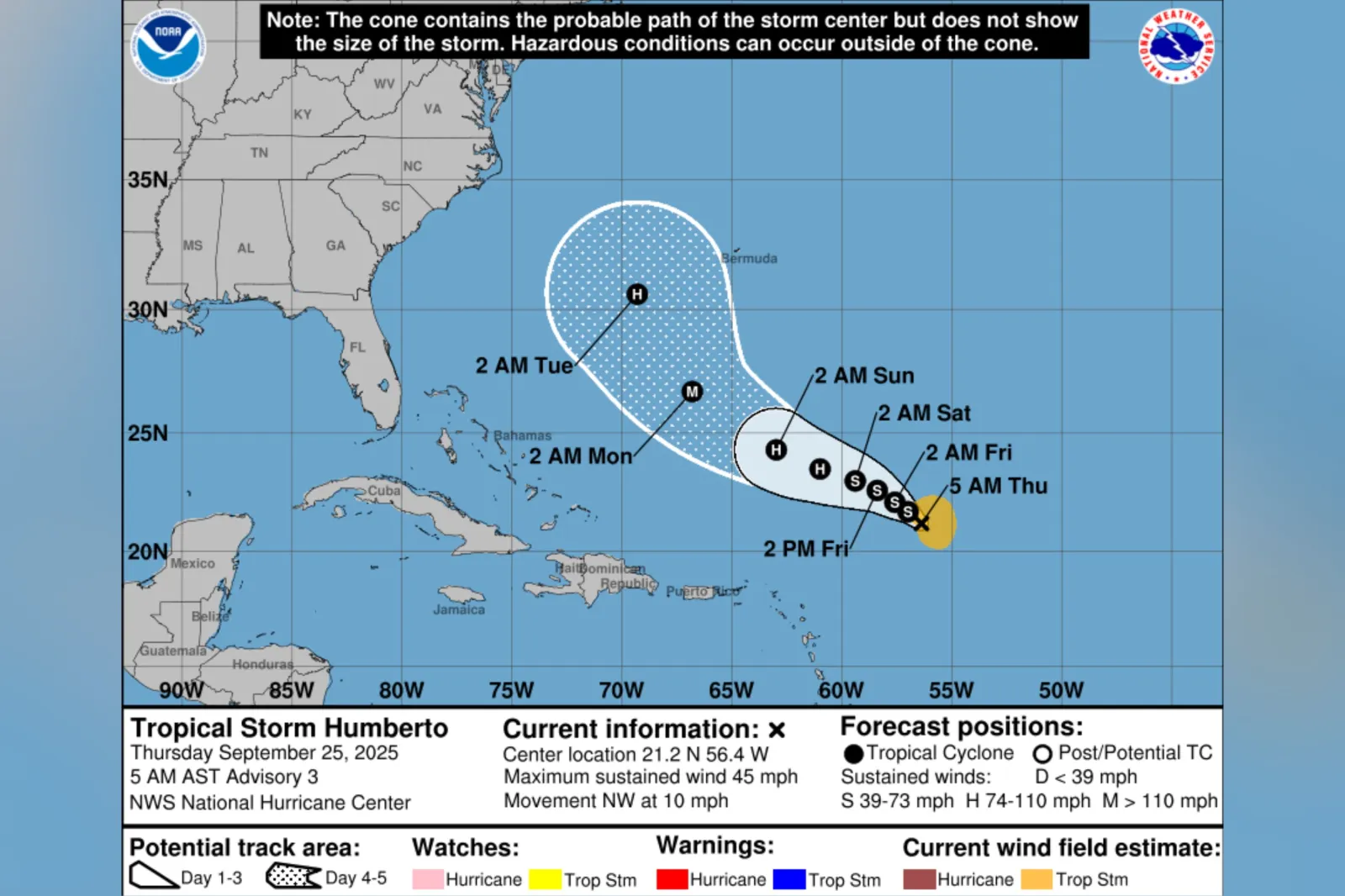
Forecasters are monitoring a busy Atlantic Ocean after Tropical Storm Humberto formed in the Central Tropical Atlantic, as Hurricane Gabrielle churns to the northeast, and a third potential cyclone threatens to follow.
Why It Matters
With Tropical Storm Humberto forecast for strengthening and another disturbance likely to form, meteorologists say the Atlantic could potentially see a rare "Fujiwhara effect"—where two storms pivot around one another, if they draw close enough to interact. This can cause storms to divert from their projected paths.
Read More on News
What To Know
As of 3 a.m. UTC Thursday, the National Hurricane Center (NHC) said Humberto was located approximately 505 miles east-northeast of the northern Leeward Islands. It was moving west-northwest near 12 miles per hour, the agency said.
...
"A west-northwest to northwest motion is expected over the next several days with a slower forward speed," it added.
The NHC reported maximum sustained winds near 45 miles per hour, with higher gusts, and said "steady strengthening" is forecast in the coming days.
Tropical-storm-force winds extended outward up to 105 miles from the system’s center, the agency said.
Meteorologists were also monitoring a disturbance nearby—dubbed Invest 94L—for possible development. If this were to strengthen into a named system, it would take the name Imelda.
As of 2 a.m. ET Thursday, the NHC gave this tropical wave, centered near the Dominican Republic, a 50 percent chance of cyclone formation through 48 hours and 80 percent through seven days. It said a tropical depression was likely to form when the disturbance nears the Bahamas late this week.
"Next week there will likely be two tropical cyclones (perhaps two hurricanes) offshore," meteorologist Jeff Berardelli said in a post on X, Wednesday. "If they are strong enough, and are close enough, a Fujiwhara may happen."
Speaking to Newsweek, AccuWeather lead hurricane expert Alex DaSilva explained: "The Fujiwhara effect happens when two cyclones within close proximity start to interact with each other. For tropical systems, the two storms usually have to be within about 850 miles of each other."
"There are a few different outcomes that can occur if two tropical systems get this close," added DaSilva. "If the storms are not close in intensity, for example one is a strong hurricane and the other is a weak tropical storm, the weaker of the storms will likely get absorbed by the larger storm.
"If the storms are of similar intensity, they may start to rotate around a common center point between the two storms. The Fujiwhara effect can cause storms to temporarily take more erratic paths. This phenomenon is more common in the western Pacific but more rare in the Atlantic."
What People Are Saying
Meteorologist James Spann said in a post on X on Wednesday: "Tonight Tropical Storm Humberto, with winds of 40 mph, is about 500 miles east/northeast of the northern Leeward Islands. It is moving to the west/northwest at 15 mph.
"Humberto is forecast to become a hurricane in a few days, but it will turn north, then northeast into the open Atlantic and is no threat to the U.S. It could be close to Bermuda early next week, however."
What Happens Next
Forecasts are sometimes subject to change, and the NHC issues regular forecast updates on its website and social media channels.
The Atlantic hurricane season began on June 1 and runs through November 30.
View 0 Comments
Submit Correction
View Editorial & AI Guidelines