10
Loading video...

By Aliss Higham
Reporter
0
Share
Newsweek is a Trust Project member
See more of our trusted coverage when you search.Prefer Newsweek on Googleto see more of our trusted coverage when you search.
The 17th named storm of the 2024 Atlantic hurricane season, Tropical Storm Rafael, has formed in the Atlantic Ocean and is expected to intensify into a hurricane this week.
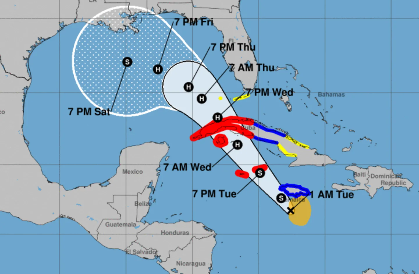
The storm is predicted to reach hurricane intensity as it passes over the Cayman Islands overnight on Tuesday before entering the Gulf of Mexico later this week. It could have impacts on the U.S. Gulf Coast, forecasters have said.
Maximum sustained winds are currently near 45 mph, the National Hurricane Center said in its Monday evening update. "Steady to rapid intensification is forecast over the next 24 to 36 hours, and Rafael is forecast to become a hurricane in the northwestern Caribbean near the Cayman Islands with further strengthening before it makes landfall in Cuba," the NHC reported.
Read More on News
More From Newsweek Vault: 5 Steps to Build an Emergency Fund Today
Warnings are currently in place for numerous regions in its path, including a hurricane warning for the Cayman Islands and the Cuban provinces of Pinar del Rio, Artemisa, La Habana, Mayabeque, Matanzas, and the Isle of Youth. A tropical storm warning is in place for Jamaica, while a tropical storm watch has been issued for Florida's Key West to west of the Channel 5 Bridge.
The heaviest impacts are expected in the island nations south of U.S. just outside the Gulf of Mexico.
"Heavy rainfall will impact areas of the Western Caribbean with the heaviest rainfall occurring over Jamaica and portions of Cuba through midweek. Rainfall totals between 3 to 6 inches with locally up to 9 inches are expected. Flooding and mudslides could occur over portions of Jamaica and Cuba.," the update reads. "Tropical-storm-force winds extend outward up to 105 miles (165 km) from the center."
More From Newsweek Vault: Online Banks vs. Traditional Banks: Learn the Differences
A graph created by AccuWeather shows Rafael will reach maximum sustained winds of 97.5 mph overnight on Wednesday and into Thursday, when the storm is forecast to reach the Gulf and will be closer to the U.S. mainland. By Friday morning, when it expected to approach the U.S., winds will have calmed to 81 mph.
...
Will Rafael Hit the US?
Weather models suggest the storm's center could eventually make landfall between Louisiana and the Western edge of the Florida Panhandle, but conditions mean it is likely to significantly weaken in the coming days.
More From Newsweek Vault: What Is an Emergency Fund?
The Weather Channel meteorologists said Rafael will likely "undergo some level of weakening in the Gulf of Mexico" due to "increasingly unfavorable upper-level winds, some dry air and cooling Gulf of Mexico waters."
"It is too soon to determine what, if any, impacts Rafael could bring to portions of the northern Gulf Coast," the NHC reports. "Residents in this area should regularly monitor updates to the forecast. Heavy rainfall will spread into Florida and adjacent areas of the south east U.S. mid to late week."
Tampa Bay based WFLA-TV chief meteorologist Jeff Berardelli said on X, formerly Twitter, that the storm will strengthen into a "powerful hurricane" before hitting Cuba, but "the good news for the U.S. is that shear and dry air will weaken the storm over the central Gulf. Florida will see fringe squalls but not much more."
September's Hurricane Helene and October's Hurricane Milton took comparable routes through the Caribbean, intensifying considerably in the Gulf of Mexico before making landfall on Florida's west coast. However, Rafael is expected to be a weaker storm moving away from Florida.
View 0 Comments
Submit Correction
View Editorial & AI Guidelines