


By Hannah Parry, Joe Edwards, and Shane Croucher
0
Share
Newsweek is a Trust Project member
See more of our trusted coverage when you search.Prefer Newsweek on Googleto see more of our trusted coverage when you search.
Days of heavy rain due to an atmospheric river that hit Washington state is culminating in the threat of record-breaking deadly flooding in some areas. "This situation is extremely serious," said Washington's Democratic Governor Bob Ferguson on Wednesday. "The next few days are critical."
What To Know
- Governor Ferguson declared a statewide emergency, warning that "lives will be at stake in the coming days.” Ferguson said he had requested "an expedited emergency declaration" from the federal government to unlock urgently-needed funding and resources for his state.
- Ferguson said: "I want to encourage all Washingtonians to listen carefully to alerts from your county and emergency management departments. If you receive an evacuation order, please follow that order. It’s critical to your safety."
- The Skagit, Sauk, Skykomish, Cowlitz, Puyallup, Carbon, Grays, Yakima, Snohomish rivers in Washington state are among those rapidly swelling and posing a serious threat to people living on the surrounding floodplains. Skagit is forecast for record-setting crests in parts in the early hours of Thursday morning.
- Level 3 evacuation orders—meaning leave immediately and seek higher ground—are in place for some areas, including anyone living within the 100-year floodplain of Skagit County and parts of Orting in Pierce County. Check your local emergency authorities to see if your area is affected too.
- There are record-breaking river water levels across Washington state as a strong atmospheric river pummeled the Pacific Northwest with extreme rainfall. NOAA National Water Center Director Ed Clark warned that rivers could remain flooded for days.
Newsweek's live blog is closed.
...
Dec 11, 2025 at 05:06 PM EST
Washington governor meets with FEMA to secure federal assistance amid record floods
Washington Gov. Bob Ferguson says he’s meeting with the Federal Emergency Management Agency (FEMA) to try and secure federal assistance amid the record-breaking flooding across the state.
“The descriptions that we’ve heard from the federal government yesterday, the National Weather Service, as describing it as potentially catastrophic and potentially having significant loss of life, still remains in place. That is our approach to this,” he said.
Dec 11, 2025 at 04:02 PM EST
Urgent evacuation notice issued for Pierce County, Washington
Residents in a residential area in Pierce County, Washington, have been told to "GO NOW" as the Pierce County Sheriff’s department goes from door-to-door urging immediate evacuation.
The sheriff’s office said that at least 25 people have been rescued in the county since Wednesday.
Dec 11, 2025 at 03:00 PM EST
At least 25 people rescued from flooded homes in Washington county
About 25 people have been rescued from their homes in Pierce County, Washington, since Wednesday which has been hard hit by the Pacific Northwest flooding, CNN reports.
Pierce County Deputy Carly Cappetto said that number is only set to increase as rescue teams are out in South Prairie and Wilkinson to help anyone trapped in their homes. Those already rescued include a 64-year-old wheelchair user whose family called 911 for help.
The Pierce County has ordered the immediate evacuation of flooded areas as many rivers in the state crested at record-breaking levels.
Dec 11, 2025 at 02:00 PM EST
New map shows huge storm moving across Northwest through Friday, bringing heavy rain and snow

Dec 11, 2025 at 01:00 PM EST
Meteorologists warn of potential mudslides after ‘days of relentless rain’ dumped more than a foot of water
An AccuWeather meteorologist has warned of more potential mudslides after more than a foot of water fell on the Pacific Northwest between Monday and Wednesday,
"Days of relentless rain have sent rivers rising to record levels. The back-to-back atmospheric rivers unleashed more water than some rivers, streams, and drainage systems can handle. More evacuations could be ordered as massive amounts of water move downstream and the river’s crest," Renee Duff, AccuWeather Senior Meteorologist said in a statement to Newsweek.
“More mudslides are possible in areas near steep terrain. Avalanches are a concern in the mountains as temperatures fluctuate over the next few days. This is an incredibly dangerous situation.”
Duff warned there was "little relief in sight for the Pacific Northwest" as the rain and snow storms are set to return to Washington early next week.
Dec 11, 2025 at 12:34 PM EST
Airports, neighborhoods at risk as river levels keep rising
Weather Channel meteorologist Justin Michaels shared footage of the rapidly rising Cedar River in Renton, Washington, on Thursday as he warned that neighborhoods and airports could be at risk if it bursts its banks.
The river "is rising fast — nearing major flood stage," he said in a post on X.
"Riverfront neighborhoods, parks, and even the Renton airport are at risk if water keeps climbing. Stay alert and avoid flooded roads."
Dec 11, 2025 at 12:01 PM EST
Skagit River hits highest water levels in 20 years
Skagit River’s water level, near Concrete, Washington, surpassed 41 feet Thursday morning.
The river looks likely to beat its record crest in October 2003 where it hit its record of 42.2 feet.
NOAA has warned that the river surpassing 40 feet may cause “severe, near-record flooding from Rockport downstream through Sedro Woolley. Deep and swift flood waters will inundate and damage roads, farms and business and residential areas, especially (in) Cape Horn, Hamilton and Thunderbird," it added.
Water levels along the Skagit have risen by more than 14 feet in just 24 hours amid heavy downpours and runoff water across Washington.
Dec 11, 2025 at 11:34 AM EST
Catastrophic flooding alert issued across Washington rivers
Dec 11, 2025 at 10:50 AM EST
Washington farmer says he’s never seen flooding like this
Washington farmer Ryan Lichttenegger, who lives outside Fall City, near the Snoqualmie River, told the Seattle Times that he'd lived through countless floods before, but the ones affecting the state this week were unheard of.
“I’ve seen many floods come and go, and I’ve never seen water come in and out of this barn like it has,” he said.
“It’s really devastating to have a flooding event like this happen before Christmas time. We have lost quite a bit.”
Washington rivers, including the Snohomish, are forecast to hit record high crests today as heavy rainfall continues along the Pacific Northwest.
Dec 11, 2025 at 10:22 AM EST
Flash Flood Watch: Washington
Western Skagit County and northwestern Snohomish County are under a Flash Flood Watch through late Friday night as the National Weather Service warns of the potential failure of levees and dikes along the Skagit River. Heavy rainfall has already driven the river into extreme flooding, and water levels are forecast to rise high enough to exceed the height and pressure limits of flood-control structures from Sedro-Woolley to the river’s mouth. Communities including Burlington, Mount Vernon, La Conner, Edison, Conway, and Stanwood face the possibility of sudden, fast-moving inundation if any section of the system fails.
Officials warn that a levee breach could lead to extensive flooding of streets, farmland, homes, and businesses, with little time for residents to react. Emergency managers urge communities to monitor alerts closely, review evacuation plans, and be prepared to act immediately if the Watch is upgraded to a Flash Flood Warning. The National Weather Service continues to track conditions and will issue updates as the situation evolves.
Dec 11, 2025 at 09:40 AM EST
Flood Watch: Montana
Northwest Montana is experiencing widespread flooding due to heavy rainfall and snowmelt, prompting multiple Flood Warnings from the National Weather Service in Missoula. Sanders County is seeing small stream flooding, with Highway 56 near Bull Lake closed due to water on the road. Lincoln County is facing more severe impacts, as rivers and streams swollen by both rain and melting snow have already inundated areas around Libby, Troy, Yaak, and Yakt. In addition, the Fisher River near Libby is expected to rise above flood stage late Thursday evening, affecting low-lying areas and roads along the river. Residents are urged to avoid flooded roads and follow safety guidance.
Further east, northern Idaho is seeing minor flooding along the St. Joe River at Calder and the Coeur d’Alene River at Cataldo, where rising waters are expected to flood low spots, farmland, and campgrounds. In Washington, rivers including the Stehekin and Wenatchee are also under flood warnings, with flooding affecting low-lying homes, roads, and river-adjacent areas in Chelan County. Across the region, officials emphasize “Turn around, don’t drown,” warning that vehicles are especially vulnerable in flooded conditions. Communities are urged to monitor forecasts closely and take immediate precautions if flooding worsens.
Dec 11, 2025 at 09:12 AM EST
Flooding Warning: Washington
Western Washington is grappling with widespread flooding as a series of strong storm systems continues to drive several rivers above flood stage. The National Weather Service in Seattle has extended warnings across King, Thurston, and Snohomish counties, where some waterways are approaching near-record levels. Officials emphasize that the greatest dangers often come from fast, unseen currents and warn drivers not to attempt crossing flooded roads, especially overnight when hazards are harder to detect.
King County is facing the most significant impacts, with flooding along the Tolt and Snoqualmie Rivers. The Tolt River above Carnation has exceeded minor flood levels, affecting Tolt River Road NE and leaving some homes in the San Souci area potentially inaccessible. More severe conditions are unfolding along both the upper and lower Snoqualmie River, where major flooding is occurring from Snoqualmie Falls downstream through Fall City and Carnation. River flows have surged well above flood thresholds, with forecasts calling for crests near or above historic highs before waters slowly begin receding late tonight into Friday.
Further south, the Skookumchuck River is causing moderate flooding around Bucoda in Thurston County, while to the north, Snohomish County is contending with major flooding along the Skykomish River near Gold Bar. Both rivers have overtopped their banks, affecting residential areas, farmland, and roadways, though gradual declines are expected through Friday and into the weekend. Emergency officials across the region continue to urge residents to keep clear of riverbanks, avoid flooded areas, and move to higher ground if waters begin to rise.
Dec 11, 2025 at 08:43 AM EST
At least eight Washington rivers and creeks have major flooding
Major flooding has hit at least eight rivers and creeks in western Washington according to the National Weather Service.
• Skagit River at Concrete, Washington: The river is expected to crest above its record level of 42.2 feet late Thursday morning. It is already more than 6 feet above the major flooding stage.
• Skagit River at Mount Vernon: The river could also break its record flood level of 37.4 feet by more than 2 feet by Friday.
• Snohomish River at Monroe: It’ is already more than 3 feet above major flood stage on Thursday morning. It is expected to crest at around its record level of 25.3 feet later today.
• Snohomish River at Snohomish: The river again is 3 feet above major flooding levels and will reach its record levels later today.
• Nooksack River at North Cedarville: The river is already almost at its previous flood record of 150.35 feet set in November 2021.
Dec 11, 2025 at 08:04 AM EST
Up to 100,000 may face evacuation: Governor
“We anticipate potentially 100,000 Washingtonians facing evacuation orders,” Washington Governor Bob Ferguson said in a social media post on Wednesday. “The situation is fluid and changing all the time. We expect rivers to hit historic levels as early as 4 a.m. tomorrow, lasting into Friday morning,” Ferguson added.
Citing the National Water Prediction Service, the governor said in another Wednesday post that the state could see 18 major floods and 15 moderate floods.
“Catastrophic flooding is likely. Please pay close attention to local officials and sign up for emergency alerts with your county,” said Ferguson.
Dec 11, 2025 at 07:33 AM EST
Atmospheric river event to diminish on Thursday: Weather Prediction Center
In a forecast discussion issued early Thursday morning, the Weather Prediction Center (WPC) said that the atmospheric river, which brought five to ten plus inches of rain over the Pacific Northwest this week “will finally come to an end today as most onshore flow weakens in response to an amplifying mid to upper- level ridge along the West Coast.
“While the heaviest rainfall is subsiding, lingering rain through Friday will exacerbate ongoing major river flooding, and landslides will continue across portions of western Washington state and northwest Oregon for several days,” it added.
Flood warnings and watches from the National Weather Service are in place across the majority of western Washington as of early Thursday morning. Similar alerts have also been issued for North Idaho and far western Montana.
Dec 11, 2025 at 07:01 AM EST
Satellite images show atmospheric river over Pacific Northwest
Satellite images shared by the Cooperative Institute for Research in the Atmosphere (CIRA) show the atmospheric river sweeping over Washington and nearby states.
The atmospheric river has resulted in widespread flooding threats, with warnings and watches spanning a wide swath of western Washington early on Thursday morning.
“This timelapse since the beginning of the week shows the relentless plume of moisture that has soaked the region,” said CIRA.
Dec 11, 2025 at 06:34 AM EST
Transport officials issue driving advice
The Washington State Department of Transportation (DOT) has issued advice for drivers as flooding impacts the state this week.
“The way you drive in heavy rain/flood conditions should look a lot different than how you drive normally,” it said. “Most importantly: Obey road closure signs and if you can't see the road, DON'T DRIVE THROUGH THE WATER.”
During wet weather, the DOT advises slowing down, leaving extra room between cars, and to watch for water pooling on the roadway. Just six inches of water is enough to stall most vehicles, it says. Two feet can sweep away vehicles, including SUVs and trucks.
“It looks like most of western Washington will be on flood watch through Friday, which ALSO means an increased risk of landslides and debris slides,” the agency added, urging residents to check conditions before hitting the road.
Dec 11, 2025 at 06:02 AM EST
Power outages as atmospheric river hits
Nearly 20,000 customers are without power across Washington amid the atmospheric river event, according to tracking website PowerOutage.com
As of early Thursday, the bulk of these are in Chelan County in central Washington, with nearly 11,000 reported outages.
A high wind warning is in place for western and central portions of the county until 4 a.m. PST Thursday as of reporting, with the NWS cautioning that damaging winds could topple trees and damage power lines. The agency is also warning of difficult travels amid the strong winds.
Elsewhere in the state, PowerOutage.com shows there are 810 outages in Skagit County, 1,037 in Kittitas County, and 2,695 in King County.
Dec 11, 2025 at 05:29 AM EST
What is an atmospheric river?
The National Weather Service (NWS) describes atmospheric rivers as “relatively long, narrow regions in the atmosphere—like rivers in the sky—that transport most of the water vapor outside of the tropics.”
Although they may differ widely in their size and strength, a typical one transports about as much water vapor as the average flow of water at the mouth of the Mississippi River. The most powerful atmospheric rivers can carry up to 15 times that amount.
“Although atmospheric rivers come in many shapes and sizes, those that contain the largest amounts of water vapor and the strongest winds can create extreme rainfall and floods, often by stalling over watersheds vulnerable to flooding. These events can disrupt travel, induce mudslides and cause catastrophic damage to life and property,” the NWS says.
They are an important part of the global water cycle and are strongly linked to both water availability and flood risk—especially in the western U.S.
Dec 11, 2025 at 04:51 AM EST
Watch: Drone footage shows river overflowing
Police in Puyallup, Washington have shared drone footage of the Puyallup river spilling over onto nearby roadways.
“We are in close communication with residents who live along the River and are advising them to be prepared” law enforcement said in a Wednesday post on X.
“According to data from the National Weather Service, the Puyallup River is forecasted to rise again tomorrow morning, but lower in the afternoon and into Friday,” Puyallup Police added.
Dec 11, 2025 at 04:21 AM EST
National Water Center warns of “locally catastrophic” flooding
“Locally catastrophic fooding impacts are possible along the Skagit and Snohomish Rivers,” the National Water Center (NWC) said on Wednesday.
“Major and/or record river flooding is expected, bringing an increasing threat to life and property,” the agency said, adding that overtopping of levees in possible.
It also said that “considerable” flooding impacts are expected to continue across the Cascade Foothills to Puget Sound into Friday.
The remainder of western Washington, as well as parts of northern Oregon, could see urban and river flooding, the NWC said.
“Landslides are possible in areas of steep terrain within the considerable region,” it added.
Dec 11, 2025 at 03:51 AM EST
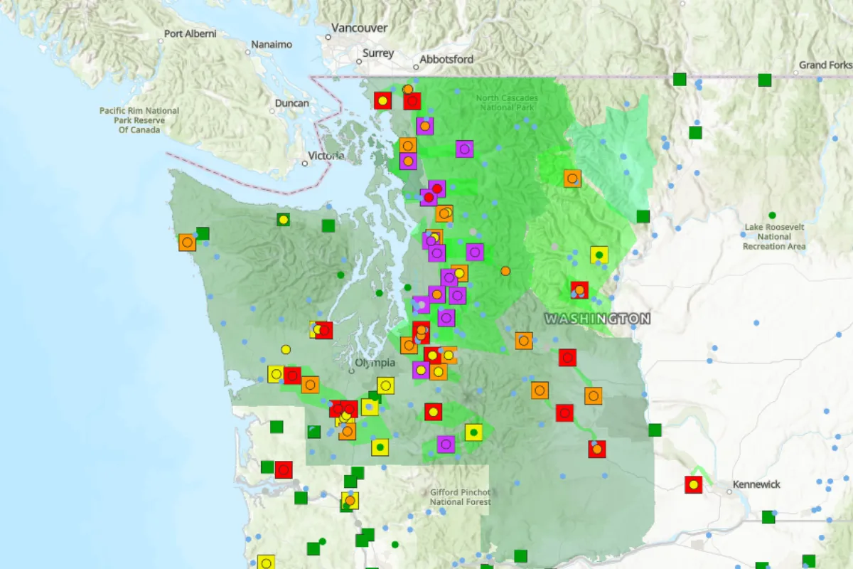
Flood watches, warnings span western Washington
Flood watches and flood warnings from the National Weather Service (NWS) are in place across western Washington early on Thursday morning.
In northwest and west central Washington, the following counties are under flood watch through Friday afternoon: Clallam, Grays Harbor, Island, Jefferson, Kitsap, Mason, San Juan, Skagit, Whatcom, King, Lewis, Pierce, Snohomish and Thurston.
In central and south central Washington, Kittitas Valley, Simcoe Highlands, Yakima Valley, and the Lower and Upper Slopes of the Eastern Washington Cascades Crest are under watch through Friday morning.
“Excessive runoff may result in flooding of rivers, creeks, streams, and other low-lying and flood-prone locations. Flooding may occur in poor drainage and urban areas,” the NWS said. “Storm drains and ditches may become clogged with debris. Area creeks and streams are running high and could flood with more heavy rain.”
Dozens of flood warnings are also in place across the state, including along parts of the Snohomish, White, and Cedar rivers.
The NWS issues flood warnings when flooding is happening or about to happen, while watches are issued when flooding is possible.
View 0 Comments
Submit Correction
View Editorial & AI Guidelines