
By Amanda Castro
Associate News Editor
0
Share
Newsweek is a Trust Project member
See more of our trusted coverage when you search.Prefer Newsweek on Googleto see more of our trusted coverage when you search.
A winter storm is set to impact southeast Nebraska and southwest Iowa this weekend, with heavy snow and freezing drizzle expected to create hazardous travel conditions. The National Weather Service (NWS) has issued both a Winter Weather Advisory and a Winter Storm Warning, with snowfall ranging from 1 to 6 inches depending on location. In addition to snow, freezing drizzle will be a concern, particularly in central areas. Drivers are urged to prepare for slippery roads, low visibility, and a risk of frostbite, as sub-zero wind chills are predicted to follow the storm early next week.
What to Know:
- Freezing drizzle is also expected to contribute to dangerous driving conditions. NWS advises that road conditions could change rapidly, and drivers should stay alert and limit travel when possible.
- With sub-zero wind chills expected, frostbite risks will be high, especially for those exposed to the elements.
- Single-digit morning lows are expected down the Mississippi Valley, with freezing temperatures projected for at least 234 million people across 40 states through next week.
- Central Iowa faces rapidly changing visibility and icy roads. In Ontario, heavy snowfall could make travel extremely dangerous.
- Typically lasting 30–60 minutes, these storms can reduce visibility to near zero in seconds and accumulate snow and ice quickly.
- As Arctic air surges south, temperatures could drop below 0°F in the northern Plains and Upper Midwest, with freezing conditions reaching as far as the Gulf Coast.
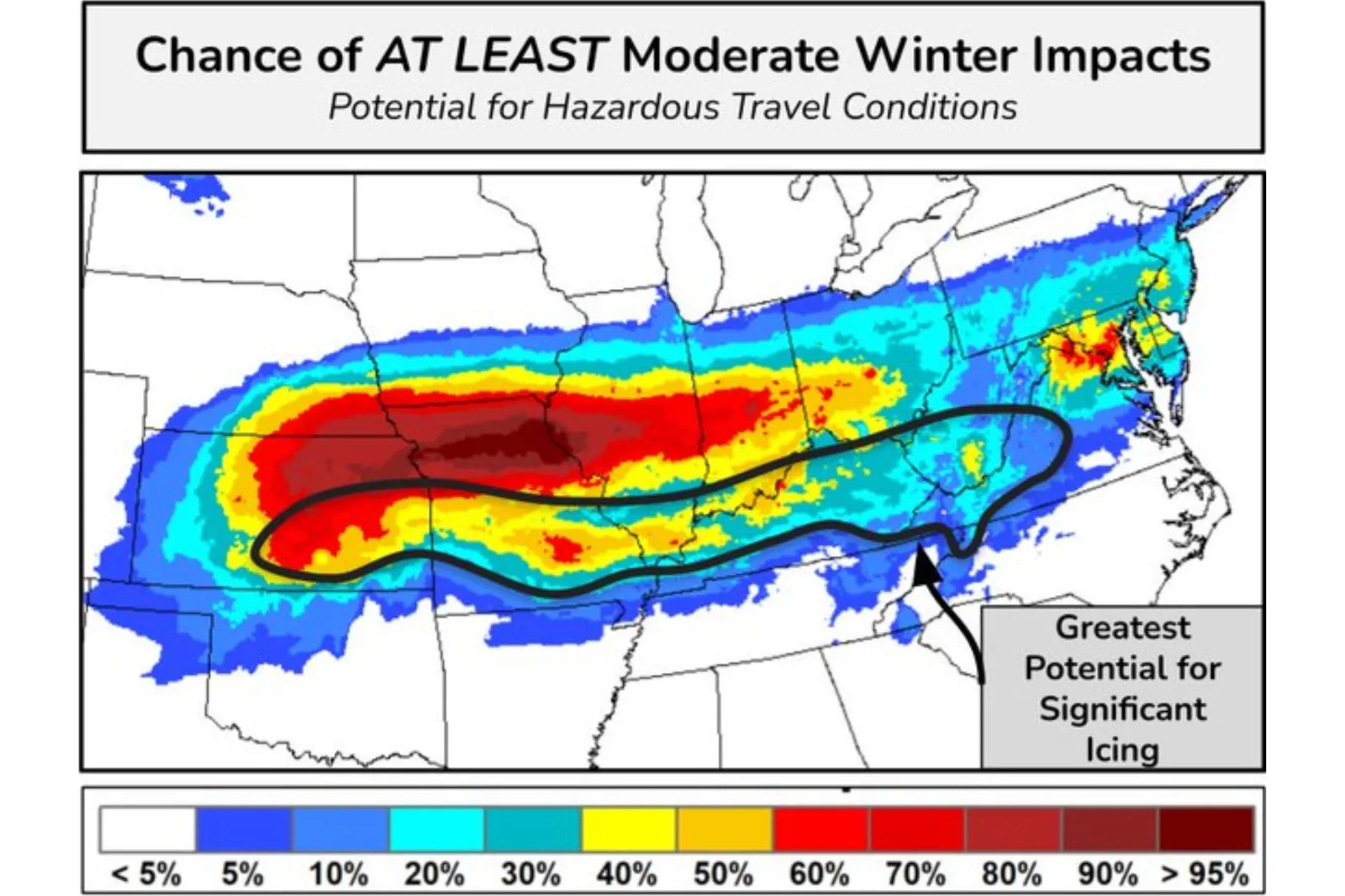
- A destructive ice storm is forecast for states like Nebraska, Kentucky, and West Virginia. With over a quarter-inch of ice accumulation expected, power lines and trees are at risk of collapse under the weight.
Newsweek's live blog has ended, but read on for the January 3, 2025's coverage.
Jan 03, 2025 at 05:54 PM EST
Snow squalls pose serious winter hazard, according to NWS

...
Snow squalls, often linked to strong cold fronts, present a significant winter weather threat, according to the National Weather Service (NWS). These fast-moving storms typically last less than an hour but can create white-out conditions in moments, leading to rapid temperature drops and icy roads. While snow squalls usually produce minor accumulations of about an inch or less, the combination of gusty winds, falling temperatures, and sudden visibility reductions makes for hazardous driving conditions.
Despite their brief duration, snow squalls have a history of causing deadly traffic accidents, particularly because of the swift changes in road conditions. Localized impacts on travel and commerce are common, as the squalls can strike without warning, even in the absence of a larger winter storm. Drivers are urged to exercise caution when traveling in areas where snow squalls are expected.
Jan 03, 2025 at 05:46 PM EST
Virginia governor declares state of emergency ahead of winter storm
Virginia Gov. Glenn Youngkin declared a state of emergency on Friday, January 3, in preparation for the first winter storm of 2025. The storm, expected to impact the state on Sunday, January 5, will bring snow and freezing rain, lasting through Monday, January 6. The storm is anticipated to affect most of Virginia, prompting Youngkin to activate various state resources to manage the storm's impact.
In a statement, the governor urged Virginians to stay alert and adjust travel plans accordingly. He recommended leaving on Saturday rather than Sunday to avoid hazardous conditions. The Virginia Department of Transportation (VDOT) has already begun pre-treating roads, and local and state officials are closely monitoring the situation.
In the aftermath of the storm, temperatures across the state are expected to remain well below freezing, with daytime highs staying under the freezing mark for the following week. Coastal Virginia is also under a gale watch through Saturday, January 4, with winds set to intensify again by Tuesday.
Jan 03, 2025 at 05:32 PM EST
Visibility reduction due to snow squalls
Visibility in Washington, D.C. is reduced due to the snow squalls in the area.
Jan 03, 2025 at 05:21 PM EST
Philadelphia experiencing colder-than-average temperatures and mixed precipitation
Philadelphia is experiencing colder-than-usual temperatures today, with an average of 32.5°F, which is 2.4°F below the city's 5-year historical average. There is a 61% chance of precipitation over the next 24 hours, with a slight chance of snow before 4 p.m., followed by rain that could mix with snow. Snow accumulation for the day is expected to be minimal, with less than half an inch possible. Additional snow is anticipated in the evening, with up to one inch likely before 7 p.m.
A Winter Weather Advisory has been issued for Philadelphia from 3 p.m. to 10 p.m. today, with total snow accumulation ranging from a light dusting to up to two inches. This could create hazardous travel conditions, particularly during the evening commute.
Looking ahead, the weather will improve slightly, with sunny skies expected on January 4th and 5th, although temperatures will remain on the chilly side, reaching highs around 33°F and 34°F. There is a chance of more snow on the 5th, mainly after 1 a.m.
Jan 03, 2025 at 05:10 PM EST
Snow emergencies declared in Jacksonville and South Jacksonville, Illinois
Snow emergencies have been issued in Jacksonville and South Jacksonville ahead of a winter storm expected to bring 6 to 12 inches of snow to west-central Illinois. A winter storm warning is in effect for the region, with heavy snow anticipated from Saturday night through Monday.
Jacksonville's snow emergency begins at 10 p.m. Saturday and will last until 10 p.m. Monday. Parking on snow emergency routes is strictly prohibited, and violators risk having their vehicles towed. Officials also urge residents to avoid parking on streets wherever possible and remind those clearing snow from private properties not to push it into public streets, as this can create hazards.
South Jacksonville's snow emergency takes effect at 6 p.m. Saturday and ends at 6 p.m. Monday. Emergency snow routes will be activated, and vehicles must be removed immediately from designated streets, including East and West Greenwood avenues, East Vandalia Road, South Diamond Street, Lincoln Avenue, and Hardin Avenue.
The National Weather Service warns that travel across parts of Illinois and Missouri could become very difficult or even impossible due to the storm. The Jacksonville-Morgan County Office of Emergency Management advises avoiding unnecessary travel. Drivers who must travel are urged to reduce speed, keep headlights on for visibility, and maintain safe distances from other vehicles.
Jan 03, 2025 at 05:01 PM EST
Motorists urged to avoid travel as Kentucky braces for winter storm
The Kentucky Transportation Cabinet (KYTC) District 8 is urging residents to avoid unnecessary travel as a significant winter storm approaches. The storm, set to hit Sunday and linger through Monday, is expected to bring freezing rain, snow, and ice to the region, creating hazardous road conditions.
Crews are preparing for extended operations, loading salt, sharpening chainsaws, and readying equipment to respond to potential power outages and tree damage caused by ice accumulations. Single-digit temperatures are likely to limit the effectiveness of road salt, adding to the challenges.
"We take snow and ice response very seriously," said Chief District Engineer James Jones. "Our highway crews work tirelessly to keep roads safe during winter storms. Please avoid travel unless absolutely necessary.
Jan 03, 2025 at 04:50 PM EST
First big winter storm of the year to blanket cities with snow
The first major winter storm of the year is set to sweep across the U.S. this weekend, bringing several inches of snow to cities like Washington, D.C., Kansas City, and St. Louis.
Meteorologists predict the storm will deliver widespread snowfall, creating slick roads and reduced visibility in affected areas.
Jan 03, 2025 at 04:36 PM EST
Winter Storm Blair and polar vortex: Live tracker
Winter Storm Blair, named by the Weather Channel, is expected to bring heavy snow, sleet, freezing rain, and ice to parts of the central United States this weekend before moving into the mid-Atlantic region on Monday, while a polar vortex may bring the coldest January the country has experienced in a decade.
Newsweek reached out to the National Weather Service (NWS) for comment via email on Friday.
The major winter storm is expected to make dangerous, "treacherous travel conditions" and result in widespread power outages for millions of Americans, according to the NWS.
On top of that, cold temperatures from a polar vortex raise concerns about energy use and heat, potentially causing natural gas to spike. In addition, freezing temperatures pose heightened health risks for vulnerable populations, including young infants and elderly individuals.
Read the full story by Mandy Taheri on Newsweek.
Jan 03, 2025 at 04:24 PM EST
‘Arctic Kraken’ to unleash frigid temperatures and snow squalls in US

...
The weakening polar jet stream is unleashing Arctic air across the United States, with Fox Weather meteorologist Bob Van Dillen likening the frigid blast to a mythical beast.
"Talk about releasing the Kraken," Van Dillen said, describing how the polar vortex is spilling southward. This cold air mass is set to bring single-digit temperatures as far down as the Mississippi Valley, with lows plunging below 0°F in the northern Plains and Upper Midwest.
Jan 03, 2025 at 04:12 PM EST
Freezing rain to cripple power lines in Midwest storm, meteorologist warns
Fox Weather meteorologist Bob Van Dillen is sounding the alarm over a multi-pronged winter storm set to hammer parts of the Midwest this weekend. The storm's most paralyzing element? Freezing rain.
"A quarter inch of ice on a 300-foot stretch of power line weighs over 280 pounds," Van Dillen told Newsweek in an email, comparing the strain to "two adult apes swinging from the power lines." With freezing rain expected to accumulate between a quarter and three-quarters of an inch in states like Kansas, Missouri, and Kentucky, widespread power outages are "almost guaranteed," he said.
The threat escalates with 20-30 mph winds accompanying the storm. "Yes, the lines will come down," Van Dillen said.
Adding to the danger is the bitter cold trailing the storm, expected to linger for over a week. "That Arctic blast comes in waves over the next 10 days," Van Dillen noted.
He also urged generator users to prioritize safety, warning that improper use can lead to tragedy: "Make sure it's outside in a well-ventilated area. Carbon monoxide is a true killer."
Jan 03, 2025 at 03:56 PM EST
Polar vortex to bring bitter cold and hazardous travel conditions
A surge of Arctic air will follow this weekend's winter storm, sending temperatures plummeting across the eastern U.S. AccuWeather experts predict subzero temperatures in parts of the Dakotas, Midwest, and Ohio Valley, creating dangerous conditions for both people and animals.
The freezing air will combine with snow and ice from the storm, leading to hazardous travel, power outages, and an increased risk of frostbite. The cold will likely extend into the Gulf Coast by midweek, with AccuWeather urging residents to take precautions against extreme cold.
Jan 03, 2025 at 03:47 PM EST
Heavy snow to blanket the plains and Mid-Atlantic, disrupting travel
A major winter storm will bring heavy snow and ice to the Plains and mid-Atlantic, with snow totals ranging from 6 to 12 inches across a large area. AccuWeather's Local StormMax reports that some areas could see up to 30 inches of snow, especially in parts of Missouri, Illinois, and Kansas.
The storm will lead to dangerous driving conditions and is expected to affect travel across the I-95 corridor, where snow and ice could impact commuters by Monday. AccuWeather is advising residents to stock up on supplies and prepare for significant travel disruptions.
Jan 03, 2025 at 03:27 PM EST
Severe ice accumulations likely to cause power outages in the Midwest
A major winter storm will bring dangerous ice accretion to parts of Missouri, Illinois, Indiana, and Kentucky this weekend. AccuWeather's Local StormMa suggests ice accumulation of up to 1.25 inches in some areas. These icy conditions are expected to cause significant travel disruptions, with roads becoming treacherous quickly.
Power outages are also a concern, as ice accumulation on trees and power lines could bring down electrical infrastructure. Residents are urged to prepare for possible extended outages.
Jan 03, 2025 at 02:13 PM EST
Severe thunderstorms in the Gulf Coast could trigger tornadoes

...
AccuWeather forecasts a moderate risk of severe thunderstorms across Louisiana and Mississippi this weekend. The storms are expected to bring hail, heavy rain, and isolated tornadoes. Some areas may experience wind gusts reaching 60 mph, which could cause property damage.
With the Gulf Coast already recovering from previous storms, AccuWeather experts are advising residents to stay alert and have a safety plan in place as these storms unfold.
Jan 03, 2025 at 01:54 PM EST
Snow and ice storm expected to disrupt travel across the plains and East Coast
As a winter storm moves eastward, snow accumulations of up to 12 inches are predicted across a large portion of the Midwest and mid-Atlantic. Areas such as Kansas, Missouri, and Illinois could see up to 30 inches of snow, with travel expected to come to a halt in many of these areas.
Icy conditions are also expected, as freezing rain will combine with snow, creating slippery roads and potentially causing dangerous power outages. AccuWeather experts are urging travelers to avoid unnecessary travel and to prepare for significant disruptions this weekend.
Jan 03, 2025 at 01:40 PM EST
Winter storm to bring significant ice accumulation to the Midwest
A major winter storm is set to impact the Midwest, with ice accretion expected to reach up to 0.50 inches in parts of Missouri, Illinois, Indiana, and Kentucky. AccuWeather warns that up to 1.25 inches of ice could accumulate in localized areas, significantly impacting travel and power infrastructure.
Freezing rain and icy conditions will create hazardous travel conditions and could lead to power outages, with widespread disruptions possible. AccuWeather advises residents to prepare for long-term outages and monitor local weather warnings.
Jan 03, 2025 at 01:27 PM EST
How isentropic lift causes dangerous ice storms
Ice storms occur when warm, moist air moves over colder air near the surface, a process called isentropic lift. Cold air, being denser, remains closer to the ground, allowing the warm air above to slide over it. This leads to freezing rain, as liquid precipitation falls but only freezes once it hits the ground.
In ice storms, temperatures can be much warmer at higher altitudes—ranging from 45 to 50 degrees—while the surface temperature remains below freezing. The rain stays liquid in the air, but freezes instantly on contact with icy surfaces, creating a dangerous buildup of ice on roads, trees, and power lines, often causing hazardous conditions and power outages.
Jan 03, 2025 at 01:16 PM EST
Snow squalls may impact region as polar vortex moves in

...
The National Weather Service is forecasting snow across the region in the coming days, with modest accumulations of up to a few inches expected in some areas. However, conditions could also support snow squalls—brief but intense storms with heavy snow, gusty winds, and near-zero visibility.
Typically linked to cold fronts, snow squalls can cause rapid and dangerous changes in weather. They are often seen in late winter and early spring when cold Arctic air collides with warmer, more moist air. This interaction creates the instability that triggers snow squalls.
The polar vortex settling over the Mid-Atlantic in the coming weeks increases the potential for these sudden storms, making travel conditions hazardous. Snow squall watches might appear in longer-term forecasts when conditions are right, but because of their unpredictable nature, warnings usually come with little preparation time.
Jan 03, 2025 at 01:04 PM EST
Snow squall warning for millions of Americans
A warning for a "dangerous" snow squall—a sudden, moderately heavy downfall of snow—has been issued for central Iowa by the National Weather Service (NWS).
Residents of the state have been told that travel "will become difficult and potentially dangerous within minutes."
A snow squall warning was also issued in Canada, according to the Weather Network, which predicted that up to 60 centimeters (almost 2 feet) of snow could fall on parts of Ontario, potentially making travel "treacherous."
Snow squalls can come on very suddenly, causing whiteout conditions and icy roads within minutes. Iowa residents have been warned to slow down while driving because of "rapid changes in visibility and road conditions."
Snow squalls are a winter weather hazard, but are not the same as a snowstorm because of their duration, the NWS says. A snowstorm is typically a lot longer, lasting for several hours or even days, while a snow squall lasts for around 30 to 60 minutes. However, they can have an extreme impact on a local level, such as deadly traffic accidents. Warnings are vital for ensuring the public's safety in those areas.
Read the full article by Jasmine Laws on Newsweek.
Jan 03, 2025 at 12:35 PM EST
Ice storms: A major winter hazard for roads, power lines, and vegetation
Ice storms are one of the most dangerous and destructive weather events, with the potential to leave widespread damage in their wake. Freezing rain, which occurs when liquid rain freezes upon contact with the ground, forms a slick, hazardous coating on everything it touches. This ice can accumulate quickly, with layers of ice sometimes exceeding an inch in thickness, which can weigh down power lines and tree branches, causing widespread power outages.
The impact of an ice storm can be severe, as even a half-inch of freezing rain is enough to snap power lines and devastate forests. Travel becomes treacherous as roadways turn into ice rinks, making driving conditions nearly impossible.
When the National Weather Service forecasts up to a quarter-inch of ice accretion, they issue a freezing rain advisory. If the ice buildup is expected to be more significant, an ice storm warning is issued, alerting the public to prepare for the possibility of extensive damage and hazardous travel.
Jan 03, 2025 at 12:22 PM EST
Winter weather advisories issued for Michigan; small craft warning along Lake Michigan

...
The National Weather Service has issued Winter Weather Advisories for portions of southwest and west-central Michigan due to lake-effect snow. Additional snow accumulations between 1 and 4 inches are expected, with some areas seeing total snow amounts of up to 8 inches. Calhoun, Barry, and Kent Counties are also under an advisory, anticipating up to 2 inches of additional snowfall and totals reaching 4 inches.
A Small Craft Advisory is in effect for areas along Lake Michigan from St. Joseph to Manistee. Northwest winds of 15 to 25 knots, with gusts up to 30 knots, and waves of 5 to 8 feet are forecasted, creating hazardous conditions for small vessels.
These advisories are in effect through Jan. 4 for snowfall impacts and January 5 for the marine advisory. Residents and travelers should prepare for slippery road conditions and difficult marine travel.
Jan 03, 2025 at 12:12 PM EST
Southern states could see rare ice storm and wintry conditions
A massive winter storm is set to hit the central and eastern United States this weekend and continue into early next week, spreading snow, ice and freezing rain across a 1,500-mile stretch from the Plains to the Atlantic coast.
Meteorologists warn that the storm will bring dangerously cold temperatures as it makes its way through major cities like St. Louis, Kansas City, Indianapolis, and Philadelphia, before leaving behind a blast of Arctic air that could see the mercury plummet to record lows in Southern states.
This upcoming storm is expected to be the first widespread winter storm of the season, with potential impacts spanning more than 1,000 miles, making it one of the most significant weather events of the year, according to AccuWeather.
Read the full story on Newsweek.
Jan 03, 2025 at 12:01 PM EST
Ice accumulation likely for central U.S.
The latest Global Forecast System (GFS) data predicts significant snowfall and ice accumulation from the Central Plains to the Ohio Valley this weekend.
Heavy snow is expected primarily north of the Ohio River, where conditions could bring substantial accumulations. Farther south, significant ice is likely, posing hazards for travel and potential power disruptions.
Residents in affected areas are advised to monitor local forecasts and prepare for winter storm impacts, including icy roads and possible power outages.
Jan 03, 2025 at 11:49 AM EST
New York polar vortex forecast: Freeze could make coldest January in years
Previous forecasts have predicted that frigid air will be pushed throughout the U.S., including the east, at least for the first half of January. Some forecasters say it has the potential to persist into the month.
AccuWeather research shared with Newsweek indicated that the intensity and reach of the Arctic air will increase during the first full week of January and persist through mid-month. At its peak, this frigid air is expected to impact over 250 million people across more than 40 states in the central and eastern U.S.
AccuWeather meteorologists predict that, while the cold air may not reach the most extreme levels experienced in the past 10 to 15 years, the prolonged duration of the frigid conditions could make this January the coldest in the United States since 2011.
Read the full story by Joe Edwards on Newsweek.
Jan 03, 2025 at 11:38 AM EST
Polar vortex pushes cold air south in winter

...
The Arctic polar vortex, a high-altitude band of strong west-to-east winds, forms each winter in the stratosphere, 10 to 30 miles above the North Pole. This phenomenon, which is always present near the poles, weakens during summer and strengthens in winter.
According to the National Weather Service, the polar vortex can expand during the Northern Hemisphere's winter, forcing frigid air to spill southward, often alongside the jet stream. This movement can result in extreme cold spells in regions far from the Arctic, affecting weather patterns across North America and beyond.
Jan 03, 2025 at 11:26 AM EST
Hundreds of flight delays so far
There have been 2,133 flight delays in the U.S so far, according to FlightAware.
Likewise, there have been 87 flight cancellations.
Jan 03, 2025 at 11:06 AM EST
U.S. energy prices spike amid polar vortex
The polar vortex sweeping across the U.S. has caused a sharp rise in home heating fuel prices, with natural gas climbing 4% in the past week and 14% over the past month. Benchmark Henry Hub natural gas reached $3.66 per million British thermal units on Thursday, peaking at $4.20 earlier in the week. Heating oil prices also jumped 5% within a week, with contracts trading at $2.35 per gallon.
The extreme cold, which may make this January the coldest in over a decade, has taken markets by surprise after years of milder winters. Nearly half of U.S. households heat with natural gas, while 40% rely on electricity. An Arctic outbreak forecasted by the National Weather Service is expected to bring subzero temperatures to parts of the Gulf Coast and Florida, posing risks to crops and infrastructure.
The Energy Information Administration predicts winter heating costs will remain steady nationally, except in the Midwest, where gas prices may increase by 11% and electricity by 6%. Rising utility costs have already forced some households to cut essential expenses.
Experts warn that prolonged severe weather could disrupt supplies, as seen during past winter storms, further straining the aging energy grid. While analysts believe markets are prepared for this cold snap, concerns remain about the impact of future extreme weather events.
Jan 03, 2025 at 10:55 AM EST
Cooler temperatures and freeze warning in Gainesville
Cooler-than-average weather is expected Thursday, with an average temperature of 49 degrees, nearly 6 degrees below the five-year historical average of 54.8 degrees.
The National Weather Service in Jacksonville issued a freeze warning until 9 a.m. for several counties, including parts of Alachua, Bradford and Gilchrist. Residents are urged to protect sensitive plants and keep outdoor pets safe from the cold.
Sunny skies are forecast, with a high near 64 degrees and lows dropping to around 38 degrees Thursday night. Areas of frost are expected early in the morning and again late at night.
Over the next three days, frosty mornings are anticipated, with daytime highs ranging from 59 to 67 degrees and nighttime lows between 37 and 51 degrees. Conditions will remain mostly sunny, turning partly cloudy by Saturday. No precipitation is expected.
Jan 03, 2025 at 10:44 AM EST
NWS shares planning timeline
The National Weather Service in Wilmington shared a planning timeline to prepare for the upcoming winter storm.
Jan 03, 2025 at 10:34 AM EST
Winter storm forecast worsens as meteorologists warn of ‘brutal mess’
The National Weather Service (NWS) has updated its forecast for a winter storm that is set to hit several states, while meteorologists are warning of the "brutal mess" it could cause for affected cities.
Challenging driving conditions may affect travel as many Americans make journeys across the country following the holiday season.
Certain vulnerable populations, such as young infants and senior citizens, face increased health risks from the dangers associated with freezing temperatures.
Read the full story by Joe Edwards on Newsweek.
Jan 03, 2025 at 10:22 AM EST
Cancellations and delays announced for Friday due to winter weather
Several school districts in Maryland have announced schedule changes on Friday, Jan. 3, 2025, due to expected winter weather conditions.
Washington County Public Schools will dismiss students two hours early, and all after-school and evening activities are canceled. After-school daycare programs at school sites may continue, but parents will be notified if there are any schedule changes. Weekend activities at WCPS schools are expected to proceed as planned.
Frederick County Public Schools will also close two hours early, with all after-school and evening activities canceled or postponed. Decisions regarding school-based daycare programs, Community School vendors, and Parks and Recreation programs will be made and communicated separately by those organizations.
Jan 03, 2025 at 10:14 AM EST
Winter storm to impact wide region with snow and ice
A major winter storm is set to affect a broad region stretching from the Central Plains to the Mid-Atlantic, bringing heavy snow and ice over several days. This storm follows closely after another significant weather event, contributing to a notably active winter season with multiple systems hitting the same areas.
Authorities are advising residents to prepare for hazardous travel conditions, potential power outages, and to ensure they have winter survival kits on hand. With dangerous conditions expected, taking precautions is essential to stay safe as the storm progresses.
Jan 03, 2025 at 10:05 AM EST
Winter storm to bring heavy snow and ice to plains, mid-Atlantic
A major winter storm is set to impact the Central Plains, Midwest, and mid-Atlantic this week, with significant snowfall and ice accumulations. The storm is expected to bring at least 6 inches of snow to areas in northeast Kansas, Missouri, central Illinois, southern Indiana, Ohio, and possibly northern Kentucky. In some regions, persistent snow bands could lead to totals exceeding a foot.
In the mid-Atlantic, moderate snowfall is expected, with areas like Baltimore and Washington, D.C., receiving up to 6 inches of snow. However, a mix of sleet may reduce snow totals in Washington, D.C. and surrounding areas. Philadelphia could also see a few inches of accumulation.
Ice in the form of sleet and freezing rain is anticipated to create hazardous conditions, especially in the Ohio Valley and Appalachians. Travel disruptions are likely, and some areas could experience tree damage and scattered power outages due to ice accumulation.
Jan 03, 2025 at 09:55 AM EST
Winter storm snow map shows cities set to be hit hardest
...
Winter Storm Blair is set to bring heavy snow and dangerous ice to parts of the U.S. this week, with cities in more than a dozen states under warnings or advisories from the National Weather Service. The storm is expected to impact the Central Plains and mid-Atlantic, where travel disruptions are likely as many Americans continue their post-holiday travel.
The storm will bring up to 6 inches of snow in some areas, including Kansas, Missouri, and Ohio, with sleet and freezing rain predicted to cause additional hazards. Vulnerable populations, including infants and seniors, face increased health risks due to the extreme cold and icy conditions. Major cities such as Baltimore, Pittsburgh, and Washington, D.C. are expected to experience wintry weather, which could result in delays or closures, according to The Weather Channel.
Meteorologists have cautioned that travel may be difficult this weekend, advising people to either travel early or delay their trips until Tuesday. The storm, which will last from January 4 to 6, is expected to cause widespread travel disruptions, and the NWS will continue to update its forecasts as conditions evolve.
Jan 03, 2025 at 09:44 AM EST
Winter storm Blair to impact central and eastern U.S.: Sunday
Snowfall, potentially heavy in some areas, will extend from Kansas to West Virginia during the day, with gusty winds creating low visibility on Sunday. Just south of the heaviest snow, a mix of sleet, freezing rain, and snow is expected to cause difficult conditions across the Ohio Valley, northeast Oklahoma, and parts of the Appalachians, The Weather Channel reported. Major cities including Cincinnati, Indianapolis, and Louisville are expected to experience treacherous travel conditions.
By Sunday night, the storm will reach the mid-Atlantic, impacting Baltimore, Pittsburgh, and Washington, D.C., making travel increasingly hazardous across the eastern U.S.
Residents in affected areas are advised to avoid travel and keep an eye on weather updates as the storm develops.
Jan 03, 2025 at 09:33 AM EST
Winter storm Blair to impact central and eastern U.S.: Saturday evening
Winter storm Blair, according to The Weather Channel, is set to bring snow, ice, and dangerous travel conditions across a large portion of the U.S. this weekend, with the worst conditions expected from Saturday through Sunday night.
Snow will begin in the northern and central Rockies, spreading eastward into the Plains by Saturday evening. Cities like Kansas City, St. Louis, and Wichita, Kansas, will face increasingly hazardous travel conditions, especially later in the day and overnight as wintry weather extends into the mid-Mississippi Valley.
Jan 03, 2025 at 09:27 AM EST
Polar vortex could make January one of coldest in years

...
A polar vortex could bring the coldest January the U.S. has faced in years.
National Weather Service experts told Newsweek that Americans can expect a colder-than-average start to the new year.
So far, this winter has seen one of the warmest Decembers on record in much of the northern United States. Though many residents experienced snow around the holidays, snow coverage was still at or near 20-year lows.
However, the polar vortex could bring severe weather conditions, including heavy snowfall and freezing temperatures, that could affect travel conditions or prompt school closures.
Read the full story by Monica Sager on Newsweek.
View 0 Comments
Submit Correction
View Editorial & AI Guidelines