AccuWeather

By Joe Edwards
Reporter
0
Share
Newsweek is a Trust Project member
See more of our trusted coverage when you search.Prefer Newsweek on Googleto see more of our trusted coverage when you search.
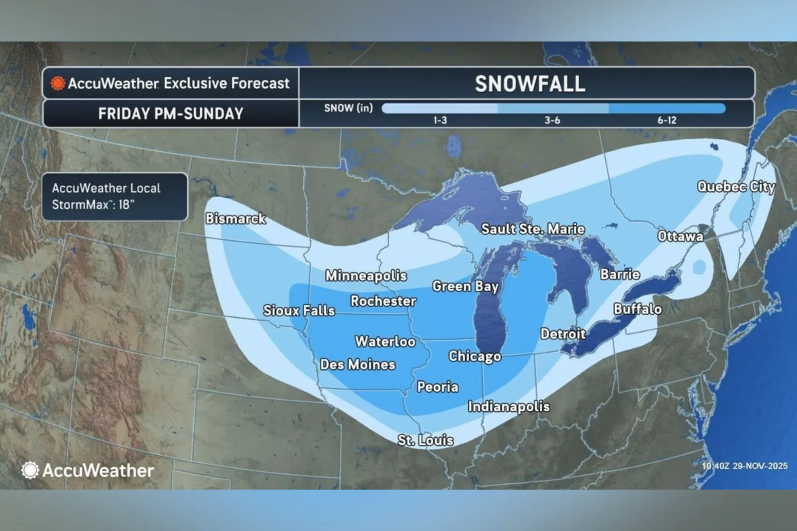
A forecast map from AccuWeather highlights which parts of the Midwest and Great Lakes can expect the most snow this weekend, with a winter storm expected to impact post-Thanksgiving travel in the region.
Why It Matters
The forecast comes after the American Automobile Association said it expects more than 80 million people to travel more than 50 miles from home over the Thanksgiving holiday period.
Read More on News
The Federal Aviation Administration also said anticipates the busiest Thanksgiving travel period in 15 years.
What To Know
According to the map, shared with Newsweek on Saturday, areas that could see between six and 12 inches of snow include parts of South Dakota, southern Minnesota, the majority of Iowa, northwest Missouri, central and southern Wisconsin, as well as portions of Illinois, Indiana, and Michigan.
...
North Dakota, Ohio, Nebraska, Pennsylvania, New York, Vermont, New Hampshire, and Maine were also expected to see snow, though in lesser amounts, the map showed.
"Air travel delays and more than 1,000 flight cancellations are possible at major hubs, including Chicago, Detroit, Minneapolis, St. Louis and Kansas City," AccuWeather said in an advisory shared with Newsweek. "Travel conditions will deteriorate along interstates 70, 80, 90 and 94, with widespread snow and ice creating difficult or dangerous driving."
Winter weather-related alerts from the National Weather Service (NWS) spanned over a dozen states early Saturday morning, with the agency cautioning drivers in some affected areas to exercise "extreme caution" due to inclement conditions.
The NWS Weather Prediction Center (WPC) said on Friday that snow was already present in parts of the northern and Central Plains, and would stretch east into the Midwest Friday night, reaching the Great Lakes region Saturday morning.
"Snow will likely be heavy at times through Saturday before tapering off slowly from west to east by Sunday morning," it said.
What People Are Saying
AccuWeather meteorologist Alyssa Glenny told Newsweek: "The corridor to face the most notable disruptions with the weekend storm include those within the six-to-12-inch snow bands, which includes Des Moines, IA; Chicago, IL; Green Bay, WI; Milwaukee, WI; and Grand Rapids; MI, to name a few. These locations are projected to pick up the heaviest snowfall rates and totals from the start of the weekend into part of the day on Sunday, which could make for rather challenging and dangerous at times."
Glenny added: "Looking ahead, we are closely monitoring a separate storm that will originate from the South-Central U.S. and advance northeastward through the Southeast and into the Northeast corridor. This storm will produce a swath of snow from Kansas and Nebraska through the Ohio Valley and into New England."
The NWS Weather Prediction Center said on X, Friday: "Heavy snow and gusty winds will lead to significant travel impacts across portions of the Plains and Midwest beginning this afternoon, carrying through Sunday morning. This will be a major winter storm for many with a large area seeing 6-12+ inches of snow over the next few days."
What Happens Next
Local forecast updates are issued regularly by the NWS on the agency’s website and via its social media channels.
View 0 Comments
Submit Correction
View Editorial & AI Guidelines