
By Amanda Castro
Associate News Editor
0
Share
Newsweek is a Trust Project member
See more of our trusted coverage when you search.Prefer Newsweek on Googleto see more of our trusted coverage when you search.
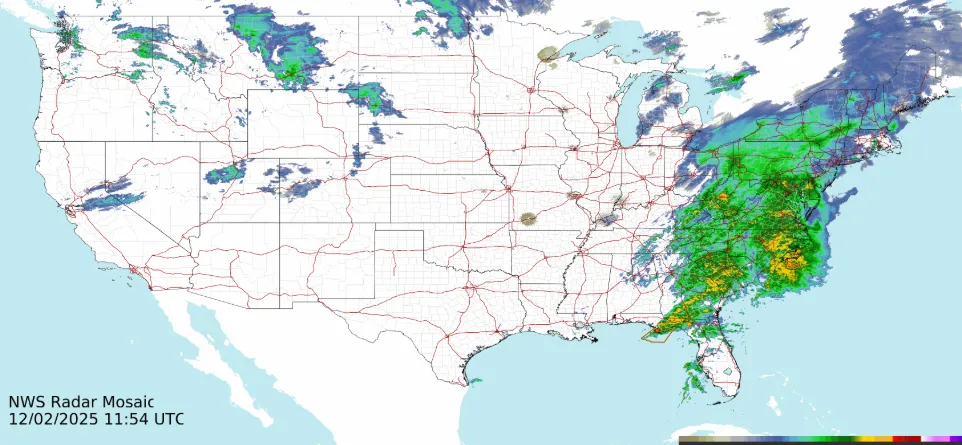
A significant winter storm is sweeping across the Midwest and Northeast, bringing heavy snow, icy roads and widespread travel disruptions. Millions remain under weather alerts as the nor’easter intensifies through Wednesday.
What to Know:
- Winter storm warnings stretch from upstate New York to eastern Maine until early Wednesday.
- Snowfall rates of more than an inch per hour are possible in Ohio, West Virginia, and western Pennsylvania.
- Six inches or more forecast across Maine, Massachusetts, New Hampshire, New Jersey, New York and Vermont; higher elevations could see over a foot.
- Coastal cities, including Baltimore, Philadelphia, and New York, are expected to see mostly rain.
- New York Gov. Kathy Hochul urged residents to avoid driving; icy conditions are expected on roads and bridges.
- New Jersey declared a state of emergency in five counties; schools across several states canceled classes.
- Maine state offices will close at noon Tuesday; Gov. Janet Mills advised residents to stock up on supplies and check on neighbors.
This live blog is now closed.
Dec 02, 2025 at 03:54 PM EST
Storm brings rain, not snow, to New York City
While parts of the Northeast are seeing accumulating snow, New York City is dealing only with cold rain and low clouds Tuesday. Temperatures hovered around 40 degrees in Manhattan, where gray skies obscured the skyline and kept sunlight from breaking through.
Snow is falling nearby in northern New Jersey, upstate New York and Connecticut, but warm air and the Atlantic Ocean have prevented flakes from reaching the city. Meteorologists note a sharp dividing line between wintry weather inland and rain along the coast.
The lack of snow in New York is not unusual. The city typically doesn’t record its first measurable snowfall—at least 0.1 inches—until mid‑December.
Dec 02, 2025 at 03:23 PM EST
Truck driver rescued after cab hangs off bridge in West Virginia
Emergency crews in Mason County, West Virginia, rescued a tractor‑trailer driver early Tuesday after the vehicle skidded on icy roads and left its cab dangling off a bridge.
The crash occurred around 5 a.m., according to county emergency management official Matt Gregg. Local fire and EMS teams responded but called in a specialized road rescue unit to safely extract the driver from the precarious position over the embankment.
The driver was pulled to safety without reported injuries. Crews remained on scene through the morning to clear the wreckage and reopen the roadway, which had been closed due to hazardous winter conditions.
Dec 02, 2025 at 02:57 PM EST
Winter storm slows commute across Northeast
A winter storm moving into the Northeast Tuesday morning is creating difficult travel conditions for millions. Light snow is falling in Buffalo and Cleveland, slowing traffic along Lake Erie. Snow is expected to taper by mid‑morning in Cleveland but linger until lunchtime in Buffalo.
In Pittsburgh, PENNDOT cameras showed snow‑covered roads with up to 2 inches already on the ground. Steady snowfall is forecast to continue through the morning commute before easing later in the day.
Farther south, Baltimore and Washington, D.C., are seeing cold rain instead of snow, with temperatures just above freezing. Philadelphia began the morning dry, but rain is expected to arrive during rush hour and persist throughout the day. Brief sleet or snow may occur along I‑95, though forecasters say it should not cause major travel issues.
Dec 02, 2025 at 02:31 PM EST
Winter storm drops several inches of snow across central Ohio
A winter storm left central Ohio blanketed in snow Tuesday morning, with totals ranging from 3 to 5 inches across the region. Columbus reported more than 4 inches by 8 a.m., while Newark saw the highest accumulation at nearly 6 inches.
Counties remain under varying snow emergency levels. Drivers in Level 2 areas are urged to travel only if necessary, while Level 3 counties have closed roads to non‑emergency traffic.
Snowfall reports included 5 inches in Bellefontaine, 4.8 in Powell, 4.5 in Gahanna and Mount Vernon, and 4 inches in Marion, Galion, Zanesville and Coshocton. Lighter amounts were recorded in Plain City and Grove City.
Forecasters say temperatures will stay at or below freezing through the week, with chances for flurries and another system tracking toward the Ohio Valley by the weekend.
Dec 02, 2025 at 01:49 PM EST
Winter storm to blanket New Hampshire with heavy snow
Snow began moving into New Hampshire early Tuesday, with several inches expected across much of the state. A winter storm warning is in effect for Carroll, Grafton, Sullivan, Merrimack, Belknap, Hillsborough, Strafford and Rockingham counties through early Wednesday, while advisories cover portions of Coos and Grafton.
Forecasters say travel will be most hazardous Tuesday afternoon and evening, with snowfall rates topping an inch per hour and visibility reduced. Central and southern areas are projected to receive 5 to 10 inches, with localized totals exceeding a foot where heavier bands persist. Lesser amounts are likely along the coast and near the Massachusetts border, where rain may mix in.
Snow is expected to taper late Tuesday night, followed by clearing skies and lows in the 20s. Another round of lighter snow showers or squalls could arrive Thursday, with temperatures plunging into the single digits by Friday morning.
Dec 02, 2025 at 01:19 PM EST
Snow transforms Kentucky governor’s mansion into winter scene
Kentucky residents woke Tuesday to a blanket of snow, including the governor’s mansion in Frankfort, which resembled a winter wonderland. Governor Andy Beshear shared a photo of the snowy landscape on social media while urging caution on the roads.
“Even if your area didn’t get snow, the rain and cold temperatures can make roadways slick. Please go slow and be careful,” Beshear wrote on X.
State crews continue treating roads to keep them open, as officials warn of hazardous travel conditions across the region.
Dec 02, 2025 at 12:55 PM EST
Winter storm brings crashes, stranded drivers across Missouri
A winter storm sweeping across Missouri created hazardous travel conditions Monday, keeping the Missouri State Patrol busy with hundreds of incidents. The agency reported handling more than 350 crashes, responding to over 800 service calls and assisting more than 200 stranded motorists.
Snowfall totals reached around 4 inches in parts of the state, contributing to slick roads and reduced visibility. Officials urged drivers to adjust to the conditions, reminding motorists to “slow down and stay alert.”
Dec 02, 2025 at 12:21 PM EST
Snow emergencies declared across central Ohio after overnight storm
A winter storm that swept through central Ohio late Monday night has prompted snow emergencies in more than two dozen counties, including Franklin County. The National Weather Service issued a Winter Weather Advisory for the region, expected to remain in effect through Tuesday morning.
Franklin County is forecast to receive 2 to 4 inches of snow, while heavier totals of 4 to 8 inches are possible farther southeast, particularly in Fairfield, Athens, Hocking and Ross counties. Hazardous travel conditions are expected during the Tuesday morning commute, with slick roads and reduced visibility.
The Ohio Committee for Severe Weather Awareness reported counties under Level 1, 2 and 3 snow emergencies. Level 1 urges caution on icy roads, Level 2 restricts travel to essential needs, and Level 3 closes roads to non‑emergency traffic. Hocking and Knox counties are under the most severe Level 3 designation.
Dec 02, 2025 at 11:58 AM EST
Winter storm to bring snow, travel disruptions across Northeast
A major winter storm is expected to complicate travel across the Northeast on Tuesday, delivering the season’s first widespread snowfall for many cities. Forecasters project 3 to 6 inches across areas including Scranton, Albany and Worcester, with heavier totals exceeding 6 inches in the southern Green and White Mountains. Localized amounts could reach up to 12 inches.
Snow may also extend to Philadelphia, New York City, and Boston, depending on the storm’s track and the position of the rain‑snow line. Meteorologists warn that even slight shifts offshore could pull in colder air, increasing the likelihood of snow along the Interstate 95 corridor.
The storm follows a weekend cold blast that entrenched Arctic air across the Midwest and Great Lakes, setting the stage for frigid temperatures and a broad zone of snow and ice concerns stretching from Oklahoma and Arkansas to the Ohio Valley and Northeast.
Dec 02, 2025 at 11:26 AM EST
Ice and heavy rain to snarl travel across Eastern U.S.
Forecasters warned Tuesday that a narrow zone near the rain‑snow line could see sleet or freezing rain, creating hazardous travel from western Virginia into southern Pennsylvania. Slippery roads are possible in the eastern Appalachians and ridge‑and‑valley region, including around Roanoke.
At the same time, heavy rain is expected to slow travel along the Interstate 95 corridor from the Carolinas to southern New England. Up to 1–2 inches may fall quickly from Atlanta through Charlotte, Washington, D.C., and Philadelphia, leading to ponding, reduced visibility and drainage problems during the morning commute.
Dec 02, 2025 at 10:51 AM EST
Arctic blast to grip central, eastern US with storm threat
A shift in the polar vortex will send Arctic air into the central and northeastern United States beginning Wednesday, forecasters said, AccuWeather reports. Daily records could be challenged as far south as the Ohio Valley and along the I‑95 corridor.
Meteorologists warn that a potential winter storm this weekend could bring snow, ice or rain to parts of the East. The outcome depends on how cold air interacts with a developing southern system. If the storm intensifies near the Atlantic coast, significant snowfall could stretch from the southern Appalachians to New England. But if frigid air dominates, the system may track offshore, limiting impacts to a narrow zone.
Dec 02, 2025 at 10:24 AM EST
Snowstorm to hit Rockies and Plains, travel disruptions expected
A new storm system is set to bring snow back to the Rockies and Plains by midweek, forecasters said Tuesday. The system, tracking southeast from British Columbia, is expected to drop 1 to 3 inches across Montana, Wyoming and Colorado, with heavier totals in mountain areas.
Snow is forecast to begin Tuesday night in Denver, potentially marking the city’s most significant snowfall of the season. Hazardous travel conditions are likely, with slippery roads and reduced visibility along a 500‑mile stretch of I‑25 and portions of interstates 70, 80, 90 and 94.
Salt Lake City, Colorado Springs and Cheyenne are also expected to see snowfall, raising the risk of airline delays and logistical challenges across the region.
Dec 02, 2025 at 09:52 AM EST
ODOT deploys more than 1,100 crews as snow covers Ohio roads
The Ohio Department of Transportation said Tuesday that more than 1,120 crews are working statewide to clear snow as heavy bands continue to move through the region. Forecasters warned that snowfall rates could reach an inch per hour in some areas, including Columbus, during the morning commute.
Despite the effort, several major routes remained snow‑covered, including I‑71 near Mansfield, I‑270 in Columbus and U.S. 23 south of the city. Officials urged drivers to stay off the roads if possible. “Give us room to work,” the department said in a statement. “If you don’t need to be out, don’t.”
Dec 02, 2025 at 09:22 AM EST
Understanding winter weather watches, warnings and advisories
The National Weather Service issues several types of alerts to help residents prepare for hazardous winter conditions. A Winter Storm Watch is typically posted at least 24 hours in advance when there is a 50 percent or greater chance of severe weather, though details on timing and location may still be uncertain. In rare cases, a Blizzard Watch may be issued instead.
As a storm becomes imminent, watches are upgraded to either Warnings or Advisories. A Warning signals an 80 percent or greater probability of dangerous conditions that threaten life or property. At the same time, an Advisory highlights significant inconveniences that could become hazardous if precautions are not taken.
Among the warnings:
- Winter Storm Warning: Heavy snow of 6 inches in 12 hours or 8 inches in 24 hours, or sleet of at least half an inch.
- Ice Storm Warning: Ice accumulation of at least one‑quarter inch.
- Blizzard Warning: Winds of 35 mph or higher with visibility under a quarter mile for at least three hours.
Advisories include:
- Freezing Rain Advisory: Ice accumulation up to one‑quarter inch.
- Winter Weather Advisory: Snow of 3 to 5 inches in 12 hours, sleet up to one‑quarter inch, or a mix of freezing rain and snow.
Dec 02, 2025 at 08:49 AM EST
Winter weather alerts stretch from Arkansas to Maine
A vast swath of the United States is under Winter Weather Advisories and Winter Storm Warnings on Tuesday, as a powerful system sweeps from Arkansas to Maine. The National Weather Service cautioned that the morning commute will be treacherous, with frozen precipitation and heavy rain expected to reach the I‑95 corridor around sunrise.
Forecasters said the storm’s wide footprint will bring a mix of snow, sleet and rain across multiple regions, creating hazardous travel conditions and slowing traffic along major highways.
Dec 02, 2025 at 08:22 AM EST
St. Louis breaks December 1 snowfall record
St. Louis set a new daily snowfall record on Monday as a winter storm swept across the country. The National Weather Service reported 3.8 inches fell in the city, surpassing the previous December 1 record of 3.5 inches set in 1937.
The storm added to widespread disruptions across the Midwest, where snow and icy conditions lingered after the Thanksgiving holiday. Forecasters said the system continues to push east, bringing hazardous travel and additional snowfall to multiple states.
Dec 02, 2025 at 08:09 AM EST
Rapid snowfall threatens morning commute across Ohio, Pennsylvania and West Virginia
Snow totals in Ohio, western Pennsylvania, and northern West Virginia may only reach 2 to 5 inches on Tuesday, but forecasters warn the accumulation will come quickly. The Weather Prediction Center said snowfall rates could exceed an inch per hour in cities including Columbus and Pittsburgh during the early morning commute.
Such rapid accumulation can make roads treacherous, with heavy snow piling up faster than crews can clear it. Later in the day, similar conditions are expected along the storm’s path from northeast Pennsylvania into eastern Maine, where forecasters anticipate intense bursts of snow through the evening.
Dec 02, 2025 at 07:56 AM EST
Heavy snowfall hits Pittsburgh as winter storm moves through region
A winter storm system brought heavy snow to western Pennsylvania early Tuesday, with Pittsburgh seeing flakes begin around 3 a.m. The National Weather Service warned that the most intense snowfall would occur between 4 a.m. and 8 a.m., with widespread totals of 2 to 4 inches expected across the region and up to 5 inches in northern areas and higher ridges.
PennDOT reduced speed limits to 45 miles per hour on several major highways, including Interstates 70, 79, 376 and 279, as well as Route 28, citing hazardous conditions. Road crews urged drivers to allow extra time, slow down and give plows space to operate.
More than 300 schools and organizations altered schedules ahead of the storm. Pittsburgh Public Schools initially announced a delay but shifted to a full closure by 5:30 a.m. Tuesday.
Officials reminded residents that Allegheny County maintains an online resource showing which agencies are responsible for clearing and plowing local roads.
Dec 02, 2025 at 07:49 AM EST
Schools and offices close across Northeast

...
Several school districts canceled classes Tuesday, including in Philadelphia, New York, New Jersey, Massachusetts and New Hampshire.
In Maine, state offices planned to close at noon, with Gov. Janet Mills urging residents to stock up on supplies and check on vulnerable neighbors.
Dec 02, 2025 at 07:44 AM EST
States issue travel and safety warnings
New York Gov. Kathy Hochul urged residents to avoid driving as icy conditions threatened roads and bridges.
In New Jersey, a state of emergency took effect at 5 a.m. in five counties, where sleet and freezing rain were forecast.
Dec 02, 2025 at 07:38 AM EST
Heavy snow forecast for New England states
By Tuesday night, six inches or more of snow is expected across Maine, Massachusetts, New Hampshire, New Jersey, New York and Vermont.
Higher elevations could see totals surpassing a foot, forecasters said, while coastal cities will likely receive rain.
Dec 02, 2025 at 07:33 AM EST
Forecasters warn of intense snowfall rates
Snowfall rates exceeding an inch per hour were expected Tuesday morning across central and southern Ohio, northern West Virginia and western Pennsylvania.
Pittsburgh was among the cities bracing for rapid accumulation, according to the Storm Prediction Center.
Dec 02, 2025 at 07:26 AM EST
Tens of millions under winter weather alerts
The National Weather Service placed tens of millions of residents across the Midwest and Northeast under winter weather advisories Tuesday.
A winter storm warning, signaling dangerous conditions, is in effect from upstate New York to eastern Maine through early Wednesday.
Dec 02, 2025 at 07:21 AM EST
Snowfall begins across New York and Pennsylvania
...
Snow blanketed parts of New York and Pennsylvania early Tuesday as a powerful nor’easter moved into the Northeast.
Forecasters warned of hazardous travel conditions and several inches of accumulation, with commuters advised to prepare for delays.
View 0 Comments
Submit Correction
View Editorial & AI Guidelines