Weather Prediction Center/X

By Joe Edwards
Reporter
0
Share
Newsweek is a Trust Project member
See more of our trusted coverage when you search.Prefer Newsweek on Googleto see more of our trusted coverage when you search.
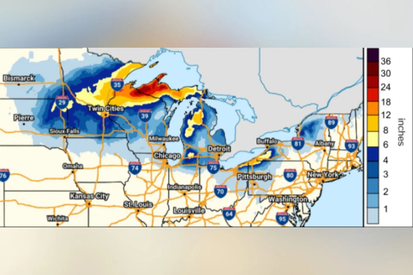
A forecast map from the Weather Prediction Center (WPC) highlights areas facing the heaviest snow as a winter storm is expected to bring dangerous travel conditions to parts of the U.S. during Thanksgiving week.
Why It Matters
Meteorologists have warned that the system could lead to challenging travel conditions, and comes as the American Automobile Association expects upward of 80 million people to travel over the Thanksgiving holiday period.
Read More on News
What To Know
The WPC said on Tuesday that a winter storm over the northern Plains would push east across Minnesota and into the Great Lakes. Blizzard conditions are expected where strong winds coincide with heavy snowfall rates, and widespread lake-effect snow will follow later this week across the region, it said.
...
The agency said that the heaviest snow would occur Tuesday night and into Wednesday across the Minnesota Arrowhead, far northern Wisconsin, and the western portions of Michigan’s Upper Peninsula.
The NWS forecast office in Marquette, Michigan, said Tuesday that snowfall totals of around 2 feet are expected through much of Michigan’s Upper Peninsula.
As of early Wednesday, blizzard warnings are in effect across Michigan’s western Upper Peninsula and northern Wisconsin, where the NWS is cautioning that widespread blowing snow could “significantly reduce visibility.”
Winter storm warnings also span nearby areas of Michigan, Wisconsin, and Minnesota.
“The areas that are going to be impacted the most with our current storm is going to be across the Upper Peninsula of and western Michigan and two other areas. One is between Cleveland and Buffalo [New York] and two is Syracuse to Watertown [both New York]. These areas are going to see the greatest lake-effect [snow],” AccuWeather senior meteorologist Tyler Roys told Newsweek on Wednesday regarding potential travel impacts.
“I-81 between Syracuse and Watertown and more likely parts of I-90 northeast of Cleveland and south of Buffalo are going to have the most difficult travel on Thanksgiving and on Friday.
“It is not out of the possibility due to snow rates of around 2 inches an hour, windy conditions (gusts upwards of 50 mph) that parts of these two highways are temporarily shut down until the snow rates and or wind gusts lessen for a period of time.
“The wind across the eastern half of the Great Lakes is going to be challenging with gusts up to 60 mph for parts of Cleveland, Erie and Buffalo. Strongest winds could occur Wednesday night and indications show that there could be power outages, especially around and south of Buffalo,” Roys added.
What People Are Saying
The National Weather Service said on X, Wednesday: “Travel conditions will be challenging across the northern Plains, Great Lakes and east coast through Thanksgiving holiday weekend. Heavy snow, blizzard conditions, for the upper Midwest and Great Lakes region through Thanksgiving to be followed by another strong storm for the Plains, Great Lakes and Northeast this weekend. Strong winds are expected with these systems adding to travel difficulties.”
The NWS explains on its website: "Lake-effect snow occurs when cold air…moves across the open waters of the Great Lakes. As the cold air passes over the unfrozen and relatively warm waters of the Great Lakes, warmth and moisture are transferred into the lowest portion of the atmosphere. The air rises, clouds form and grow into a narrow band that produces 2 to 3 inches of snow per hour or more.
What Happens Next
Local forecast updates are regularly issued by regional NWS branches via the agency’s website and social media channels.
View 0 Comments
Submit Correction
View Editorial & AI Guidelines