

By Amanda Castro and Hannah Parry
0
Share
Newsweek is a Trust Project member
See more of our trusted coverage when you search.Prefer Newsweek on Googleto see more of our trusted coverage when you search.
A winter storm is sweeping across the U.S., killing people's power and bringing life-threatening snow squalls, near-blizzard conditions, and bitterly cold temperatures to the Great Lakes, the mid-Atlantic, and the Northeast. This new system follows closely on the heels of the season's first major lake-effect snowstorm, leaving many regions struggling to recover before the next round of severe weather is upon them. Winter weather alerts blanket a vast portion of the country, such as Wisconsin and Maine, per Fox Weather meteorologists. Blizzard warnings have been issued for portions of West Virginia, Maryland, and Pennsylvania, where forecasters warn people about dangerous travel and whiteout conditions. The storm is being driven by a fresh surge of arctic air, plunging wind chills below zero in parts of the Plains and Upper Midwest. Many communities in northeastern Connecticut are dealing with power disruptions as the snowstorm moves through the state Thursday. The cold is expected to extend into the Northeast, with temperatures falling into the teens along the Interstate 95 corridor, including New York City, the publication reports.
This live blog is now closed.
Dec 05, 2024 at 01:50 PM EST
Boston should expect cooler-than-usual temps
Boston is experiencing cooler-than-usual temperatures on December 5th, with the day's average temperature hitting 35.5°F, a drop of 3.4°F below the 5-year historical average of 38.9°F. The city is also facing a 100% chance of precipitation, with rain showers expected before 5 p.m. and a mix of rain and snow afterward.
Temperatures are expected to stay low throughout the day, with a high near 44°F. Winds will be strong, blowing from the west at 20 to 23 mph, bringing a chill. Tonight, the temperature will dip to around 26°F with mostly clear skies.
Dec 05, 2024 at 01:04 PM EST
Areas with the best chance of snow this holiday
AccuWeather has revealed the cities across the U.S. with the highest chances of getting hit with a "white Christmas" this year.
"It's been a cold start to December for much of the eastern half of the nation. Don't expect the cold to stick around too much longer. We expect a pattern shift in mid-December with a change from a cold Polar air mass to a milder Pacific air mass, especially for the central and eastern United States," AccuWeather Lead Long-Range Expert Paul Pastelok said. "This can lead to snow melt for many areas that received snow at the start of the winter season, not leaving too much snow around just before Christmas."
On the list are:
- Denver, Colorado
- Chicago, Illinois
- Indianapolis, Indiana
- Boston, Massachussetts
- Columbus, Ohio
- New York City, New York
Dec 05, 2024 at 12:32 PM EST
Arctic cold front with winds of up to 80 mph to batter the Northeast
National Weather Service (NWS) has warned that powerful winds of up to 80 mph will accompany an Artic cold front hitting the Northeast today.
Intense, heavy snowfall and strong, gusty winds may produce dangerous whiteouts and icy roads, making a deadly mix for travelers.
The 80 mph winds and snowfall may also knock down trees and cause power outages.
In a forecast today, the NWS said: "Below normal temperatures will follow the arctic front for much of the northern and eastern U.S. Snowfall totals of 1-2 feet are expected in the lake-effect snow belts, with up to 1 foot likely along the central Appalachians and across the higher terrain of interior New England. A Blizzard Warning remains in effect for a part of the central Appalachians."
Dec 05, 2024 at 11:25 AM EST
Connecticut customers without power
Stafford, Connecticut residents are without power as the first snowfall of the season hits.
As of 10:55 a.m. Thursday, 4,665 Stafford residents were without power, accounting for more than 71% of Eversource's customers in the town.
Up to 82% of Stafford Eversource customers lost power Thursday morning.
Eversource said the majority of the outages were caused by tree branches, and some customers should expect to have power restored by 2:30 p.m. Thursday.
Dec 05, 2024 at 11:15 AM EST
Map shows heavy snowfall across New England
A new map from National Weather Service shows heavy snowfall across southern New England.
Some areas reported receiving up to 12 inches of snow overnight, while many areas received between four and six inches.
Dec 05, 2024 at 10:57 AM EST
Power outages reported due to wet snow
New England is seeing power outages because of the "heavy wet snow" falling in some areas.
Dec 05, 2024 at 10:33 AM EST
Life-threatening snow squall hits New York highways

...
National Weather Service (NWS) meteorologists are warning motorists of a dangerous snow squall in the Binghamton, New York, forecast region that could become life-threatening.
The warning comes as a potent winter storm lashes the Northeast on Thursday, with several embedded snow squalls disrupting travel. Snow squalls are intense periods of heavy snow that can emerge with little warning and make for dangerous driving conditions.
At around 10 a.m. ET on Thursday morning, one such squall was causing "intense bursts of heavy snow" at the following locations:
Interstate 86/Route 17 between Exits 34 North and 40; Interstate 390 between Exits 1 and 3; Interstate 86/Route 17 between Exits 92 and 114; New York Interstate 81 between Exits 6 and 7; Interstate 86/Route 17 between Exits 78 and 80 and Interstate 88 between Exits 2 and 6.
Read the full story by Anna Skinner on Newsweek.
Dec 05, 2024 at 10:21 AM EST
America’s snowiest cities, ranked
The Weather Channel has shared a list of the snowiest cities and towns in America by analyzing 30 years' worth of average snowfall statistics.
Here are the top snowiest cities and towns in the U.S.:
- Valdez, Alaska
- Sherman, New York
- Truckee, California
- Crested Butte, Colorado
- Marquette, Michigan
- Lead, South Carolina
- Terra Alta, West Virginia
- Hurley, Wisconsin
- Snyderville, Utah
- Red Lodge, Montana
Dec 05, 2024 at 09:58 AM EST
Mild, dry day in Sacramento
Sacramento's weather on December 5th, 2024, is expected to be warmer than usual, with an average temperature of 51.5°F, which is about 2.9°F above the 5-year historical average of 48.6°F. While temperatures are mild, there is minimal chance of precipitation, with just a 1% chance of rain over the next 24 hours.
The day will be mostly cloudy with patchy fog overnight, and temperatures will range from a low of 41°F at night to a high of 62°F during the day. Widespread dense fog is also expected to develop after 11 p.m. and last until 5 a.m. on December 6th.
Looking ahead, patchy fog is forecasted to continue through December 6th and 7th, with partly sunny skies and temperatures in the low 60s during the day and lows near 40°F at night.
Dec 05, 2024 at 09:45 AM EST
Temperatures nearly 30 percent colder than usual in Detroit
Detroit is facing a chilly day with average temperatures of 24.5F, nearly 30 percent colder than normal for this time of year.
Temperatures are likely to get even colder in coming days, dropping as low 19F, with highs of 35F.
The city has moderate chance of snow overnight so residents may wake up to a light dusting tomorrow.
Dec 05, 2024 at 09:44 AM EST
NWS shares tips on how to stay safe during snow squalls
The National Weather Service has shared some safety tips to keep you safe during a snow squall.
It recommends you:
- Avoid or delay motor travel
- Reduce speed, turn on headlights, and try to exit the road
Dec 05, 2024 at 09:37 AM EST
Cleveland bracing for more snow
Snow, potentially 18 inches or more, might be going to Erie County.
The National Weather Service in Cleveland issued a new lake-effect snow warning for Erie and Crawford counties, effective Wednesday at 4 p.m. and ending Saturday at 1 a.m. It replaces a winter storm watch issued on Tuesday and comes after a days-long lake-effect snow warning that expired at 7 p.m. Tuesday.
Corry, Union City, Edinboro, and Erie were among the areas covered by the lake-effect snow warning.
Dec 05, 2024 at 09:30 AM EST
Urgent snow squall warning issued across New York counties
A snow squall warning has been issued for several New York counties including Sussex, Monroe, Warren, Northampton.
The warning is in place until 10.15 a.m.
Snow squalls are a rapid weather hazard that can create sudden whiteout conditions and icy roads within minutes.
The National Weather Service warns that snow squalls can cause localized "extreme impacts" to travel and have a "long history of deadly traffic accidents associated with" them."
Dec 05, 2024 at 09:22 AM EST
One million Americans advised to prepare for winter weather

...
The city of Austin, Texas, is preparing for winter weather as cold snaps and winter storms become increasingly frequent.
The city's nearly 1 million residents have been advised to be proactive and prepare for extreme weather conditions as winter sets in.
"Being proactive is key to preparedness," Bill Wilson, interim director of the Office of Homeland Security and Emergency Management, said in a statement released by the city of Austin.
"We may be hit with snow, ice, and extreme cold, which can affect you, your loved ones, and pets. It can disrupt electricity, water, gas, roads, and other things people rely on. We are here to help you prepare, so you are in a better position when winter weather hits."
To prepare, people are advised to protect the four "Ps"—people, pets, pipes, and plants.
The four steps of preparedness are to make a plan, build a kit, know your neighbors, and stay informed.
Officials have also provided extensive guidance on how to prepare for issues caused by cold weather and how to prepare homes for winter. This includes repairing drafty areas, insulating pipes and keeping emergency items in homes and vehicles.
Austin Mayor Kirk Watson and other officials said in a press conference on Wednesday that the city was preparing for winter, but that residents should also be prepared themselves.
Read the full story by Alia Shoaib on Newsweek.
Dec 05, 2024 at 09:10 AM EST
What classifies as a blizzard?

...
The National Weather Service (NWS) has shared information on what classifies as a blizzard, which are deadly winter storms that combine blowing snow and wind, resulting in extremely limited visibility. Blizzards are frequently accompanied by massive snowfalls and extreme cold. Strong winds can take up previously fallen snow, resulting in a ground blizzard.
The NWS defines a blizzard as a storm with huge volumes of snow OR blowing snow, winds greater than 35 mph, and visibility less than 1/4 mile for at least 3 hours. Blizzard conditions are often encountered on the northwest side of a severe storm system. The difference between the storm's lower pressure and the higher pressure to the west generates a tight pressure gradient, or pressure differential between the two sites, resulting in extremely powerful winds. These high winds take up available snow from the ground or blow any snow that falls, resulting in extremely limited visibility and the possibility of substantial snow drifting.
Dec 05, 2024 at 08:57 AM EST
Washington, D.C. temperatures below average this week
The average temperature for Washington, D.C., this week is forecast to be around 41.5°F, slightly below the five-year average of 43.47°F. This marks a deviation of about 1.97°F or roughly 4.5% cooler than usual for the first week of December. Although this deviation is relatively small, it indicates that temperatures will be a bit colder than what is typically expected for this time of year.
The week's weather will start with a cold day on December 5, as temperatures will struggle to reach a high of 38°F, with a low of 27°F. Wind speeds will pick up, with gusty west winds of 16 to 22 mph, adding to the chill. The following day, December 6, will see similar conditions with mostly clear skies, and a high of 38°F and a low of 25°F. By December 7, temperatures are expected to remain chilly, reaching a high of 41°F and a low of 27°F, with partly cloudy skies.
As the weekend approaches, conditions will begin to warm up slightly. On December 8, the high will climb to 52°F, with a low of 38°F, and there will be a chance of showers. The following day, December 9, showers are more likely, with temperatures rising to 55°F and a low of 48°F. A warm front will move in on December 10, pushing temperatures to 64°F, though there will still be a chance of rain. The week will close out on December 11 with highs around 55°F, although the low temperature for the day is not yet available.
Dec 05, 2024 at 08:52 AM EST
NWS shares message regarding snow squalls
The National Weather Service has shared a number of "key messages for the evolving snow squall, strong wind, & heavy snow setup in the Great Lakes & Northeast."
Dec 05, 2024 at 08:38 AM EST
What is lake-effect snow?

...
The National Weather Service defines lake effect snow as occurring when cold air, mostly from Canada, flows across the open waters of the Great Lakes. As cold air flows over the unfrozen and comparatively warm waters of the Great Lakes, warmth and moisture are transmitted to the lower atmosphere. As the air rises, clouds gather and expand into a tight band, producing 2 to 3 inches of snow per hour or more.
This phenomenon is widespread in the Great Lakes area in late autumn and winter.
Wind direction is an important factor in deciding whether places may see lake-effect snow. Heavy snow may fall in one spot while the sun shines a mile or two distant in either direction. The physical topography of land and sea is equally significant.
Dec 05, 2024 at 08:33 AM EST
Mohawk Valley expecting visit from Alberta Clipper
The National Weather Service in Binghamton is reporting that an Alberta clipper is sweeping across the northern U.S. delivering a lot of snow to the Mohawk Valley.
An Alberta clipper is a quick, low-pressure storm that arises in the Canadian Rocky Mountains and normally brings a lot of snow with it.
Meteorologist Michael Kistner said this is "pretty potent," per Observer-Dispatch.
"This system doesn't have a lot of moisture, so it won't have a lot of snow, but a lot more colder [sic] air is going to filter in behind it, and in areas like the Mohawk Valley and Tug Hill, that cold air taps into the lake moisture from Lake Ontario," Kistner said. "It's going to enhance the snowfall in the Mohawk Valley and Tug Hill region, with Oneida County being where we expect the most snow."
Dec 05, 2024 at 08:18 AM EST
Winter weather warnings for 13 states as “whiteout conditions” feared
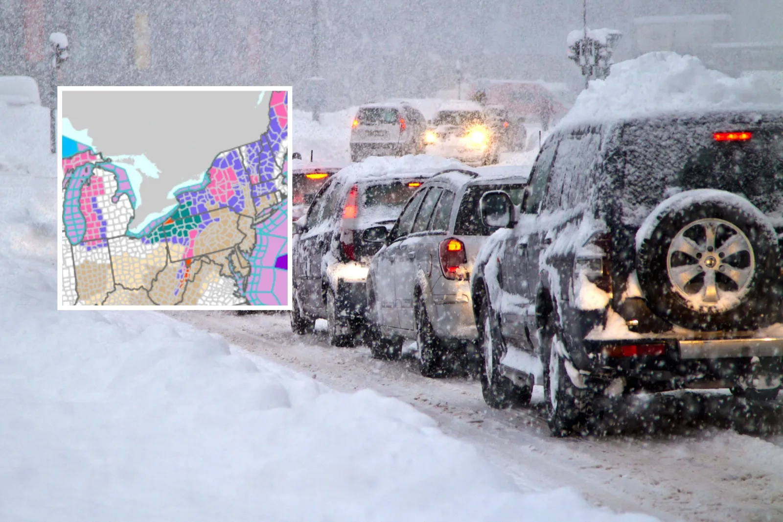
...
Millions of people across the Northeast and Midwest are hunkering down as frigid winter weather and thick snow heads their way.
Winter Weather Advisories have been issued across Connecticut, Maine, Massachusetts, New Hampshire, New York, Pennsylvania and Vermont, as well as small sections of Indiana, Michigan, Ohio, West Virginia and Wisconsin.
Whiteout conditions may also occur in these areas, making for hazardous traveling on the roads.
Additionally, Winter Storm Warnings have been issued for parts of Indiana, Maine, Michigan, New York, Pennsylvania, Vermont and Wisconsin.
There are also small areas of Maryland, northwestern Pennsylvania and West Virginia and under Blizzard Warnings.
Read the full story by Jess Thomson on Newsweek.
Dec 05, 2024 at 08:05 AM EST
Boston expecting snow squalls
The winter storm affecting Massachusetts might deliver snow squalls to the area around noon Thursday. These will cause a rush of wet snowflakes as the storm begins to subside.
Significant accumulation from the squall is not expected because temperatures will be well above freezing and rain will have fallen throughout much of the event in the city, NBC Boston reports.
Dec 05, 2024 at 07:51 AM EST
Travel should be avoided in some areas
The National Weather Service has issued multiple winter weather advisories for the Great Lakes and the interior Northeast. These advisories are for both snow from the storm system itself and lake-effect snow that has formed in the aftermath of its passage.
The Weather Channel reported that blizzard warnings have been posted for Erie, Pennsylvania, and higher elevations in the middle Appalachians.
Avoid travel during blizzards, winter storms, and lake-effect snow warnings.
Dec 05, 2024 at 07:40 AM EST
Blizzard warning as “treacherous” whiteout conditions expected
Portions of Maryland and West Virginia are under a blizzard warning Wednesday night into Thursday morning as whiteout conditions are expected for travelers.
The National Weather Service said the warning begins at 9 p.m. ET Wednesday and runs until 3 p.m. ET on Thursday. Up to 9 inches of snow are possible, along with potential wind gusts up to 60 mph. The NWS added that the worst conditions, including the heaviest snow and strongest winds, are expected from midnight until noon.
The potential impacts of these whiteout conditions could make travel in the region "treacherous," the NWS said. The warning includes Interstate 68, Highway 219 corridors, Highway 33 west of Seneca Rocks, and Highways 48 and 50 west of Bismarck and Mount Storm.
On X (formerly Twitter), NWS Baltimore-Washington posted about the conditions, saying in part, "A high impact weather system is set to move through tonight through Thursday bringing blizzard conditions to portions of the Alleghenies & very gusty winds to the entire area."
Visibility in these portions of Garrett County, Maryland, and western Grant and western Pendleton counties in West Virginia will be one-quarter mile or less, the NWS warned.
Read the full story by Anna Commander on Newsweek.
Dec 05, 2024 at 07:28 AM EST
What are snow squalls? Winter weather hazard threatens travel chaos

...
As an Arctic cold front sweeps across the mid-Atlantic and Northeast this Thursday, snow squalls are expected to create hazardous travel conditions for travelers across the region.
The National Weather Service (NWS) has warned of intense bursts of heavy snowfall and gusty winds up to 50 mph, leading to whiteouts, icy roads and dangerous commutes.
Areas along Interstate 95, from Washington to Baltimore, Philadelphia and New York City, are particularly vulnerable during the morning hours. From Hartford, Connecticut, to Boston and Portland, Maine, is at risk around midday, according to AccuWeather forecasts.
These conditions have the potential to trigger multi-vehicle pileups and cause widespread disruptions. In addition to snowfall, powerful winds could down tree branches, cause power outages and turn unsecured items into airborne hazards.
"Along I-95, on Thursday morning and midday, rain showers will transition to snow showers," Alyssa Glenny, a meteorologist at AccuWeather, said in a statement.
"In some cases, a heavy snow squall will pass through a portion of the I-95 zone, which can briefly make bridges, overpasses and elevated surfaces slushy in a matter of minutes."
Read the full story by Tom Howarth on Newsweek.
View 0 Comments
Submit Correction
View Editorial & AI Guidelines