Newsweek/Weather warnings map

By Joe Edwards
Reporter
0
Share
Newsweek is a Trust Project member
See more of our trusted coverage when you search.Prefer Newsweek on Googleto see more of our trusted coverage when you search.
Wintry weather was set to impact large portions of the United States on Thursday, with the National Weather Service (NWS) issuing winter storm warnings for at least 10 states and winter weather advisories for nine others.
Forecasters warned that some regions could see up to 3 feet of snow, along with dangerous travel conditions and potential power outages.
Why It Matters
The NWS forecast heavy snowfall, strong winds, and ice accumulation, affecting millions of Americans. Travel disruptions are likely, the service said, advising residents in affected areas to prepare for hazardous conditions.
Read More on News
Frigid temperatures may pose health risks, particularly for vulnerable groups such as infants and older adults.
Winter storms can also trigger power outages, while heavy snowfall may hinder travel and create hazardous driving conditions.
What To Know
AccuWeather meteorologist Grady Gilman told Newsweek that a storm system will be pushing through the West today, spreading snow across the Wasatch Range of Utah and across the central and southern Rockies.
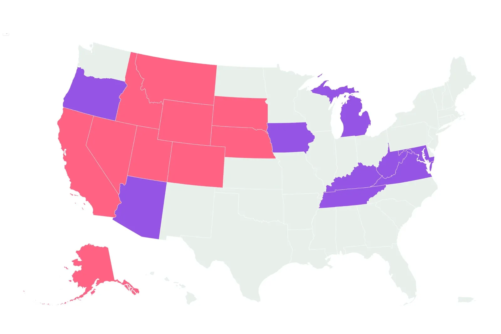
As of early Thursday morning, the NWS had winter storm warnings in place for Alaska, California, Nevada, Utah, Colorado, Wyoming, Nebraska, South Dakota, Montana, and Idaho.
These areas were expected to experience some of the heaviest snowfall, with the Ruby Mountains and East Humboldt Range in Nevada's Elko County forecast to receive up to 3 feet of snow.
The NWS issues winter storm warnings when "a significant combination of hazardous winter weather is occurring or imminent."
In addition, winter weather advisories had been issued for Oregon, Arizona, Michigan, Tennessee, Virginia, Kentucky, West Virginia, Maryland, and Alaska. While these areas generally were not expected to see as much snowfall, they will still face difficult travel conditions due to snow, ice, and strong winds.
The National Weather Service (NWS) issues these "for any amount of freezing rain, or when two to four inches of snow (alone or in combination with sleet and freezing rain), is expected to cause a significant inconvenience, but not serious enough to warrant a warning."
What People Are Saying
AccuWeather meteorologist Grady Gilman told Newsweek: The heaviest snow will occur across the mountains of Utah, Wyoming and Colorado where a general 6 to 12 inches of snow is expected, 1 to 2 feet across the highest elevations above 10,000 feet, though upward of 2 to 3 feet can even occur across the highest of peaks."
NWS Riverton, Wyoming, said on X, formerly Twitter, yesterday: "A winter storm system will bring widespread snow to much of the area tonight through FRI morning. The heaviest snowfall will be THURS morning through THURS afternoon. Travel will become hazardous so be sure to use extra caution when traveling on THURS!"
What Happens Next
"Going through tonight and Friday morning, low pressure will be organizing over the central High Plains and this will allow heavy snowfall that will be impacting large areas of Wyoming to develop off to the east across areas of southwest South Dakota and much of Western and northern Nebraska where as much as six to 12 inches of snow will be possible through Friday morning," the NWS forecast.
Snow will reach parts of the Midwest, including Iowa and northern Illinois, with expected accumulations of at least a few inches, the service said.
View 0 Comments
Submit Correction
View Editorial & AI Guidelines