
...

By Anna Skinner
Associate News Editor
0
Share
Newsweek is a Trust Project member
See more of our trusted coverage when you search.Prefer Newsweek on Googleto see more of our trusted coverage when you search.
California’s snowpack got a February boost but still trails normal for early March, prompting state officials to warn that time is running out to catch up before the typical April 1 peak.
The Department of Water Resources (DWR) said its third survey found conditions “in better shape" than a month ago, yet still below average statewide after warm storms caused lower‑elevation melt. Snow is effectively California’s largest natural reservoir, and its seasonal accumulation and melt determine how much water will flow into rivers and reservoirs through spring and summer. In a state where snowpack typically supplies about a third of annual water needs, water managers rely on a deep, cold snowpack to carry the state through long dry periods and buffer drought conditions.
The DWR’s latest update underscores a split season: cold, snow‑producing storms in mid‑February improved totals, but overall accumulation remains lagging, especially in the north. As of this week, the state’s SnowTrax dashboard shows the statewide snowpack at only 59 percent of normal to date and 54 percent of the April 1 average, well below early‑March levels in recent years. For example, snowpack levels were at 85 percent of average in 2025 after the February survey.
Read More on Weather
"Over the past 25 years, there are no years where the statewide snowpack was at or below the current levels (59% of average to date) and made a recovery to 100% of the April 1 condition," David Rizzardo, Hydrology Section Manager for DWR’s Hydrology and Flood Operations Branch, told Newsweek. "There were some years where 15-20% was added during March, but nothing on the order of adding 30% or more during March. There are also several years where we lost snowpack in March, which is our current concern."
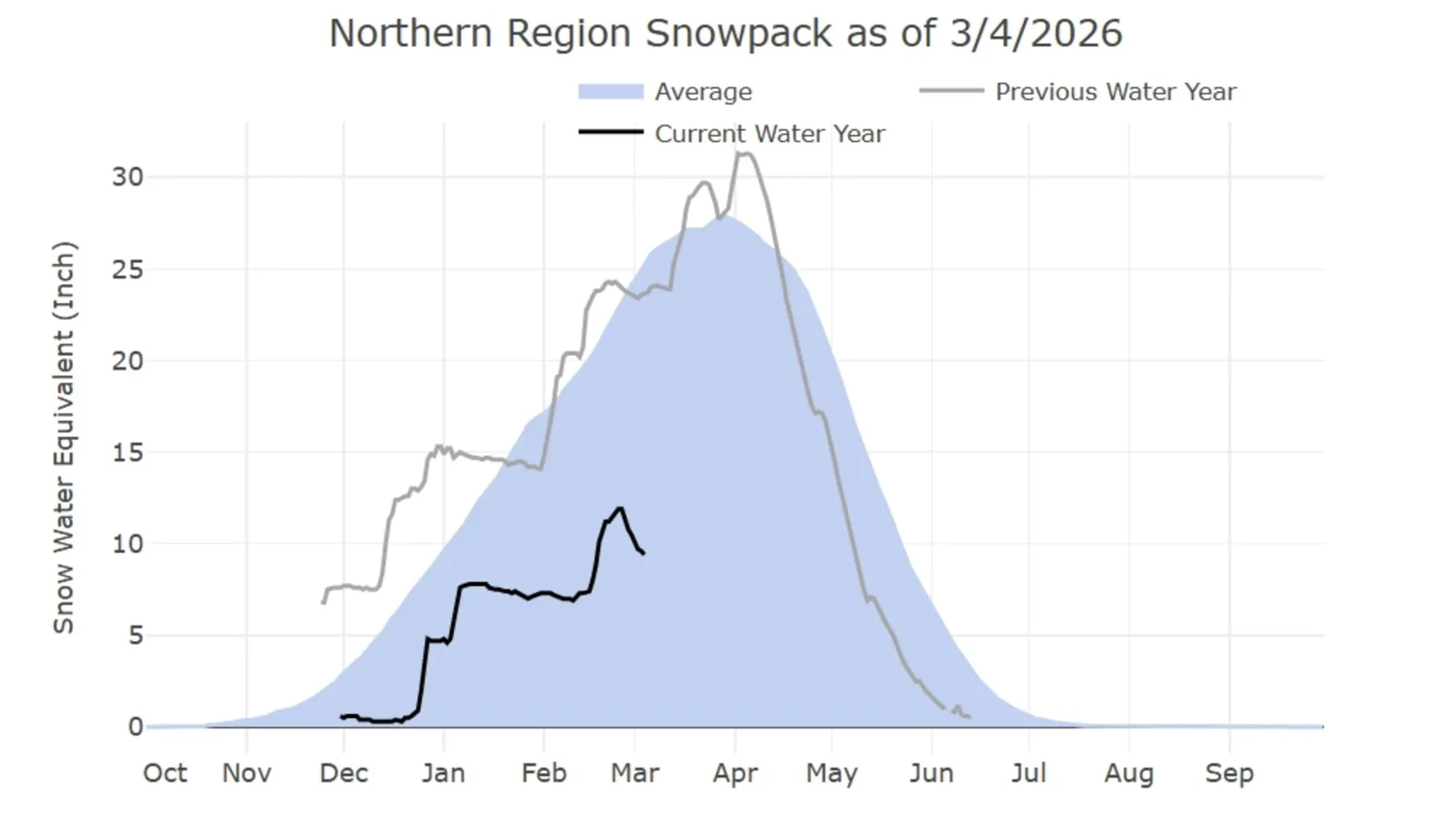
Northern California Snowpack
This region is experiencing the most concerning lag in average snowpack at this time of year. As of March 4, DWR data show that snowpack is only 38 percent of normal for this time of year, a far cry from last year's 100 percent of normal.
...
The graph reveals a steep rise in snowpack levels during mid-February storms, but improvement plunged after peaking at 53 percent of normal on February 24. Now, the regional snowpack tracks well below historical numbers for early March, reflecting fewer cold storms and more rain at lower elevations.
DWR flags this shortfall as especially concerning because many of the state’s largest reservoirs draw from the north.
Central California Snowpack
As of March 4, the Central California snowpack is 62 percent of normal for this time of year. The performance in this region is better than in the north, but the snowpack here still lags behind its 2025 numbers, which were 76 percent of normal this time last year.
The central Sierra Nevada snowpack climbed sharply with February’s cold storms, then fell again, leaving totals near two‑thirds of normal for the date.

...
Southern California Snowpack
The best-performing statewide is the southern Sierra Nevada, currently at 82 percent of average for this time of year. The southern Sierra Nevada has seen the most impactful snowfall so far this year, putting its snowpack above last year's for the same region at this time. Last year, on March 4, 2025, the snowpack in the southern region was 70 percent of normal.

...
Snowpack Improvement 'Not Enough'
“Although the storms we saw in mid-February were some of the coldest and best snow-producing storms we have seen since 2023, they were not enough to get us back to average conditions,” Andy Reising, Manager of DWR’s Snow Surveys and Water Supply Forecasting Unit, said in a DWR press release.
“The snowpack is in better shape than it was one month ago, but we only have a month left of our snow-accumulation season and time is rapidly running out to catch up. Statewide, we are only about 57 percent of where we hope to be by April 1.”
Winter storms that occur between December and March typically produce the largest snowfall across the state. However, California's annual water supply is becoming increasingly dependent on very few storms.
"Water supply in California increasingly depends on a small number of big storms,” DWR Director Karla Nemeth said in the press release. “We face higher drought risk when they don’t arrive and greater urgency to modernize infrastructure to capture water when they do. The dramatic wet-dry swings this winter remind us again that ever-warmer average temperatures have reshaped the California water cycle. We must adapt.”
Update 3/10/2026, 2:02 p.m. ET: This article was updated with additional information.
In a polarized era, the center is dismissed as bland. At Newsweek, ours is different: The Courageous Center—it's not "both sides," it's sharp, challenging and alive with ideas. We follow facts, not factions. If that sounds like the kind of journalism you want to see thrive, we need you.
When you become a Newsweek Member, you support a mission to keep the center strong and vibrant. Members enjoy: Ad-free browsing, exclusive content and editor conversations. Help keep the center courageous. Join today.


View 0 Comments
Submit Correction
View Editorial & AI Guidelines