...

By Anna Skinner
Associate News Editor
0
Share
Newsweek is a Trust Project member
See more of our trusted coverage when you search.Prefer Newsweek on Googleto see more of our trusted coverage when you search.
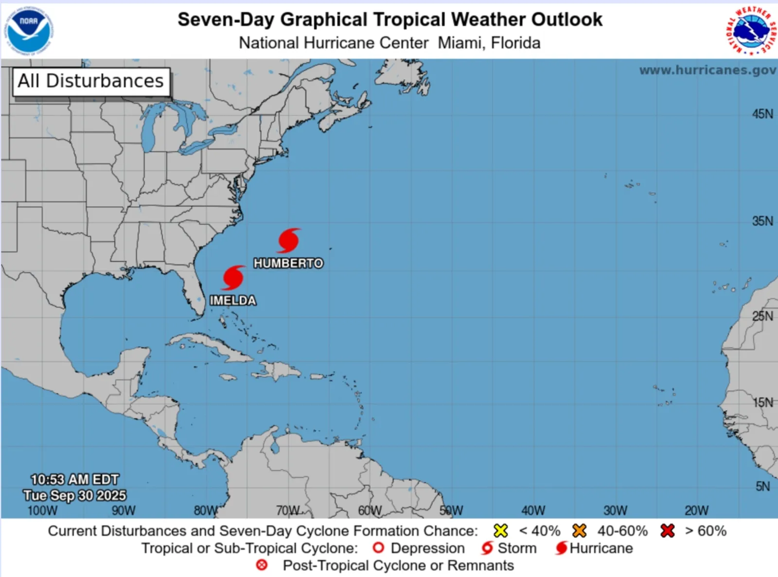
AccuWeather meteorologists are reminding Americans that hurricane season is still in full swing as two hurricanes churn off the East Coast.
"Hurricane season is far from over," AccuWeather Lead Hurricane Expert Alex DaSilva said in a forecast emailed to reporters on Tuesday morning.
Why It Matters
The Atlantic hurricane season runs from June 1 through November 30. Earlier this year, the National Oceanic and Atmospheric Administration (NOAA) predicted between 13 and 19 named storms, with six to 10 of those strengthening into hurricanes. After a slow start to the season earlier this year, in which no storms were in place during the season's typical peak activity in mid-September, AccuWeather meteorologists are predicting an increase in activity for the season's last few months.
Read More on News
"We always thought there would be a midsummer lull to some degree and then things would pick up," DaSilva told Newsweek. "We've already seen a little bit of a jump in the activity. We do expect ... there to be more storms for the rest of the season."
What to Know
Hurricane Humberto and Hurricane Imelda are the most recent storms to form during this year's Atlantic hurricane season. So far this season, nine named storms have formed.
...
"It’s important to remind everyone that the Atlantic hurricane season runs through the end of November. We have been forecasting a much more active second half of the hurricane season since the spring," DaSilva said in Tuesday's forecast.
The message comes as the Fujiwhara Effect takes place between the two hurricanes in the Atlantic. This rare effect occurs when two tropical cyclones spinning in the same direction come close enough to each other that they begin to interact, essentially doing a "dance" around their common center, according to the NWS. The effect can alter the storm paths. In this case, Hurricane Humberto pulled Hurricane Imelda away from the U.S. East Coast.
As of the most recent update from the National Hurricane Center (NHC), Hurricane Imelda and Hurricane Humberto are both Category 1 storms with 80 mph winds.
Looking forward, there are two more areas for potential tropical development in the Atlantic basin in early October. AccuWeather reported a "low risk of development" in the Bay of Campeche and warned people in Eastern Mexico to monitor the forecasts. Forecasters also are monitoring a tropical wave moving across the Atlantic that could see development this weekend.
What People Are Saying
DaSilva said in a forecast: "Rainy and breezy conditions along the coast of the Carolinas and Virginia could linger throughout Tuesday. Both storms churning through the Atlantic are producing dangerous rip currents and rough surf. Beaches from Florida to New Jersey may have hazardous conditions through the weekend.”
NHC in a post on X: "A hurricane warning has been issued for Bermuda. #Imelda is expected to bring damaging winds, waves, and heavy rainfall Wednesday into Thursday. Life-threatening rip currents will continue to affect the U.S. east coast beaches through the week."
What Happens Next
Both Hurricane Imelda and Hurricane Humberto are moving away from the U.S. Some indirect impacts, such as dangerous waves and currents, are expected. Bermuda is also expecting impacts from the storms. People residing in hurricane prone areas are urged to follow local weather guidance and remain vigilant through the remainder of the hurricane season.
View 0 Comments
Submit Correction
View Editorial & AI Guidelines