CPC

By Joe Edwards
Reporter
0
Share
Newsweek is a Trust Project member
See more of our trusted coverage when you search.Prefer Newsweek on Googleto see more of our trusted coverage when you search.
The western U.S. is facing a “major pattern change” this month, forecasters said, following a stretch of warmer-than-normal conditions across the region.
In an update Monday, the National Weather Service (NWS) Climate Prediction Center (CPC) said the developing shift “favors an increased risk of hazardous weather over much of the western half of the U.S.”
“A high risk for heavy precipitation is highlighted across coastal California, including the San Francisco, Los Angeles, and San Diego metropolitan areas for Feb. 17, with a moderate risk continuing through Feb. 18 and extending into southwestern Oregon,” the CPC said, cautioning that “any heavy rainfall may trigger small stream, urban, or flash flooding.”
Read More on News
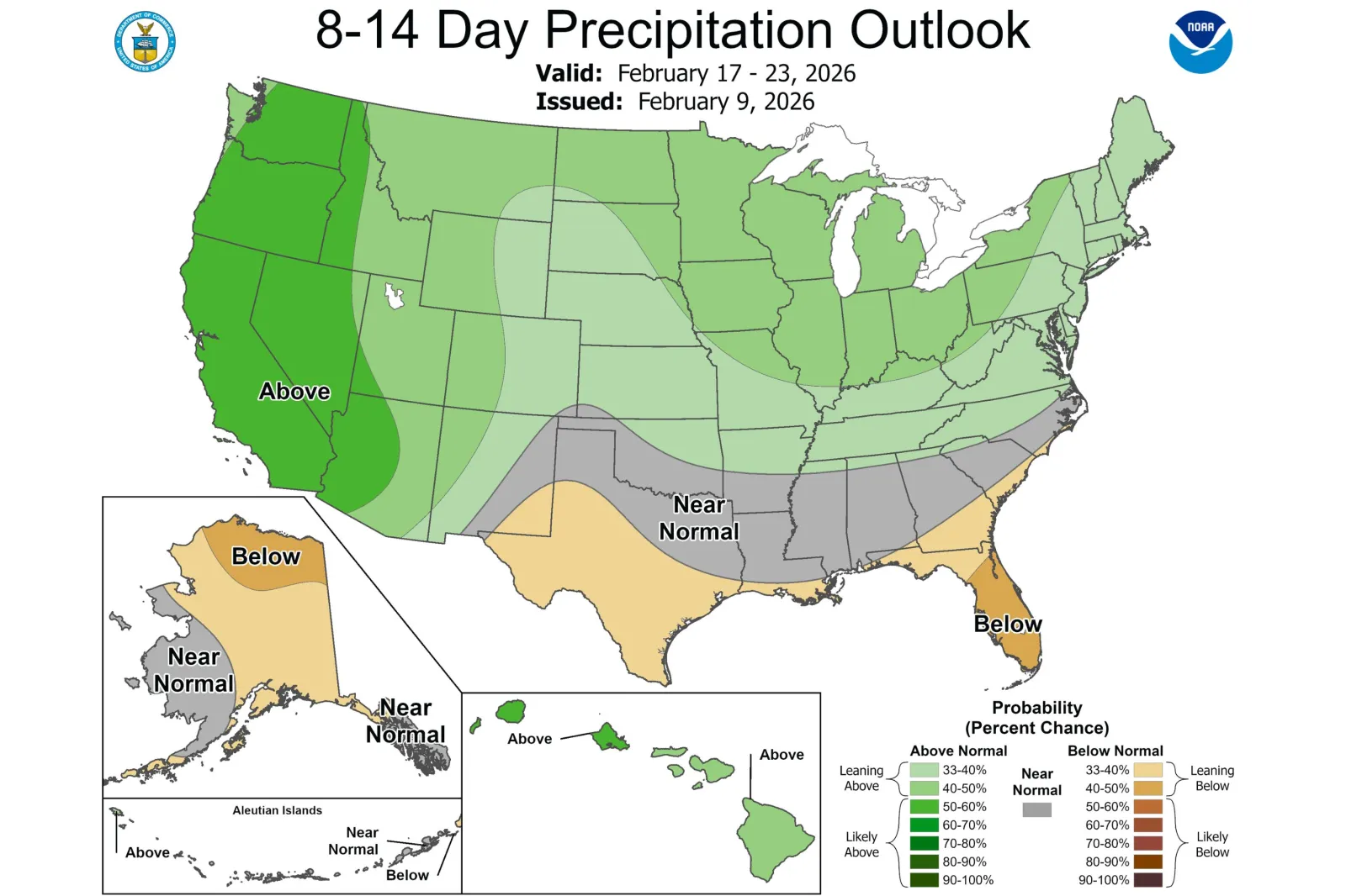
A forecast map for February 17-23 showed the highest odds of above‑normal precipitation across California, Washington, Oregon, Idaho, Nevada and Arizona.
...
The CPC added that a “moderate to high” risk of heavy snow exists for higher elevations of the West, including the southern Cascades, Klamath region, Sierra Nevada and parts of northern Arizona.
It also highlighted the potential for high winds across the Four Corners and High Plains—conditions that it warned could contribute to “an elevated wildfire risk.”
“A winter storm also cannot be ruled out across the Northern Plains and Upper Midwest, although this is more uncertain,” the CPC said.
Fox Weather noted that the western U.S. has seen weeks of unusually warm temperatures, leaving many mountain ranges in a state of snow drought.
On Thursday, the CPC reported that the snow-water equivalent was less than half of average across the Pacific Northwest, Four Corners, Great Basin and California.
“Following above-normal temperatures across the West during late January and early February, a transition to much cooler temperatures is forecast for Feb. 13-19. Below-normal temperatures are favored across the Pacific Northwest, Great Basin, and California,” the center said.
“The cooler, wetter pattern would yield periods of snow, possibly heavy, to the Cascades, Sierra Nevada Mountains, and higher elevations of the Great Basin.”
NWS Los Angeles said Sunday that southwest California is “almost certain” to see rain between February 14 and 19, though the agency noted that there remains a range of possible outcomes for rainfall amounts, intensities and associated impacts.
Local forecast updates are issued by the NWS regularly via its website and associated social media channels.
In a polarized era, the center is dismissed as bland. At Newsweek, ours is different: The Courageous Center—it's not "both sides," it's sharp, challenging and alive with ideas. We follow facts, not factions. If that sounds like the kind of journalism you want to see thrive, we need you.
When you become a Newsweek Member, you support a mission to keep the center strong and vibrant. Members enjoy: Ad-free browsing, exclusive content and editor conversations. Help keep the center courageous. Join today.


View 0 Comments
Submit Correction
View Editorial & AI Guidelines