
By Joe Edwards
Reporter
0
Share
Newsweek is a Trust Project member
See more of our trusted coverage when you search.Prefer Newsweek on Googleto see more of our trusted coverage when you search.
Some meteorologists are cautioning that the Atlantic waters off the U.S. coast could soon face the prospect of two hurricanes at the same time.
Why It Matters
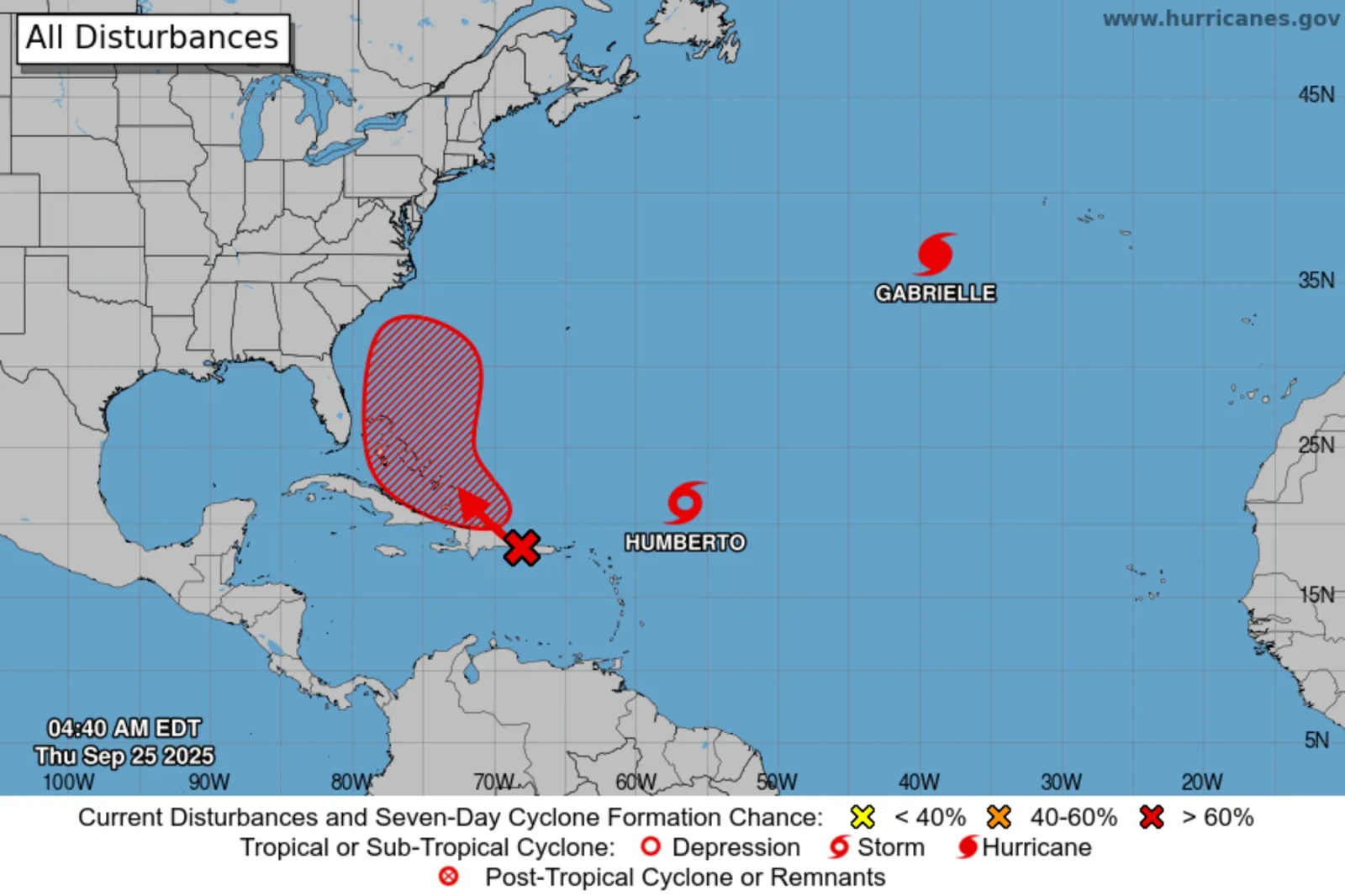
With Tropical Storm Humberto forecast for strengthening and another disturbance likely to form, meteorologists say the Atlantic could potentially see a "Fujiwhara effect"—where two storms pivot around one another, if they draw close enough to interact.
Read More on News
What To Know
As of 9 a.m. UTC on Thursday, the NHC said Humberto was located approximately 480 miles east-northeast of the northern Leeward Islands.
“Humberto is moving toward the northwest near 10 mph (17 km/h). A west-northwest to northwest motion is expected over the next several days with a slower forward speed,” it said.
The agency reported maximum sustained winds near 45 miles per hour, with higher gusts, and said the system was expected to strengthen over the next several days.
Meteorologists were also monitoring a disturbance nearby—dubbed Invest 94L for possible development. If this were to strengthen into a named system, it would take the name Imelda.
...
In an update on Invest 94L, the NHC said an area of low pressure is expected to form along a tropical wave Thursday night or early Friday when the disturbance moves near the southeast Bahamas.
“This low is expected to become a tropical depression when it is in the vicinity of the central and northwest Bahamas in a couple of days,” it said.
“Next week there will likely be two tropical cyclones (perhaps two hurricanes) offshore,” meteorologist Jeff Berardelli said in a post on X, Wednesday. “If they are strong enough, and are close enough, a Fujiwhara may happen.”
An advisory from AccuWeather shared with Newsweek on Thursday said the exact track and strength of Invest 94L, should it become a tropical depression or named storm, would determine the magnitude and location of impacts to the U.S. Southeast early next week.
“The first scenario sees the storm with lower wind intensity and being guided east toward a stronger Humberto (likely a major hurricane early next week). This may cause the storm to become completely enveloped and absorbed by Humberto, or dancing it around it in...phenomena known as the Fujiwhara Effect,” the outlet said, adding that in this situation the U.S. impacts could be limited to rough surf and possible rip currents for the East Coast.
A second scenario projects the storm strengthening and moving more directly toward the Southeast U.S. coast early next week. Staying separate from Hurricane Humberto, it would bring more direct rain and wind impacts, especially to the Carolinas, AccuWeather said.
Invest 94L and Tropical Storm Humberto Spaghetti Models
Spaghetti models—computer models that illustrate potential storm paths using meteorological data—suggested Invest 94L could track near the Carolina Coast, while Humberto could remain far offshore.
What People Are Saying
NHC hurricane specialist branch chief Dan Brown told Newsweek, Friday: "The potential for the two systems to interact makes the track and intensity forecast for each more challenging. NOAA has been flying its hurricane hunter aircraft over the western Atlantic to collect data around each system and the NWS has been launching additional weather balloons. This data collection that will continue through the weekend will provide weather models with additional data."
Meteorologist David Paul said on X, Wednesday: “Twin hurricanes early next week?!?! Definitely a possibility. Tropical Storm Humberto formed Wednesday afternoon and the tropical wave near Puerto Rico may form by Friday/Saturday. The AI ECMWF model shows both as potent storms Tuesday evening in the Atlantic. The steering currents look to carry both out to sea, but the Eastern Seaboard will have to monitor the western system, to be safe.”
Meteorologist Ryan Maue said in a post on X, Wednesday: “By Monday, we will be watching a 'twin tropical cyclone' system: Imelda and Humberto.
“The eastern storm will be massive with Cat 5 potential and dominate the overall track of the binary system—until it detaches and moves away.”
What Happens Next
Forecasts are sometimes subject to change, with the NHC issuing updates regularly on its website and social media channels.
The Atlantic hurricane season began on June 1 and runs through November 30.
Update, 09/30/2025, 1:04 p.m. ET: This article was updated with comment from Dan Brown.
View 0 Comments
Submit Correction
View Editorial & AI Guidelines