
By Amanda Castro
Associate News Editor
0
Share
Newsweek is a Trust Project member
See more of our trusted coverage when you search.Prefer Newsweek on Googleto see more of our trusted coverage when you search.
Tropical Storm Imelda is expected to intensify into a hurricane as it tracks along the Southeast coast this week, bringing hazardous surf, rip currents, and coastal flooding from Florida to the Carolinas. Meanwhile, Hurricane Humberto remains a powerful Category 4 storm, amplifying threats to U.S. beaches and posing a rare double danger to Bermuda.
What to Know:
- Imelda is forecast to reach hurricane strength by Tuesday near Florida’s Atlantic coast.
- Humberto, once a rare Category 5 storm, remains a Category 4 storm with widespread coastal impacts.
- Both storms are fueling rip currents, beach erosion, and flooding from Florida to the Carolinas.
- Bermuda faces back-to-back hurricane threats, with Imelda possibly making landfall midweek.
- South Carolina and Charleston have declared states of emergency and begun preparations for the storm.
- The U.S. has so far avoided hurricane landfall in 2025, but every storm has rapidly intensified.
Stay with Newsweek for the latest updates.
Sep 29, 2025 at 02:29 PM EDT
Imelda and Humberto stir Atlantic as dual storm threat looms
Tropical Storm Imelda drenched the Caribbean early Monday, joining Hurricane Humberto as two active systems swirling in the Atlantic. Humberto, a powerful Category 4 storm as of late Sunday, remains farther offshore but is expected to generate dangerous surf and rip currents along the U.S. East Coast starting Monday.
The proximity of the two storms raises the possibility of interaction through the Fujiwhara effect, a meteorological phenomenon where nearby cyclones influence each other’s movement and intensity. Current forecasts suggest both Imelda and Humberto will veer away from the U.S. mainland in the coming days.
Tropical storm warnings were issued across the Bahamas, with watches extending to Bermuda. Heavy rainfall is forecast for parts of the Bahamas and Cuba through Tuesday, with the potential for flash flooding. Although Florida’s storm watch was lifted Sunday afternoon, forecasters warn that Imelda could still bring significant rain to the Carolinas through midweek.
Sep 29, 2025 at 02:26 PM EDT
WATCH: Hurricane Humberto satellite view of the churning eye
Sep 29, 2025 at 01:58 PM EDT
Global hurricane patterns: What drives storm frequency and intensity
Global Hurricane Patterns: What Drives Storm Frequency and Intensity
Each year, approximately 80 tropical cyclones form worldwide, with about one-third of them reaching hurricane strength. The western Pacific Ocean is the most active region due to its vast expanse of warm water, whereas the Atlantic averages around ten storms annually, with six of these typically developing into hurricanes. The Atlantic’s smaller size and shallower warm water layer contribute to its lower storm count compared to the Pacific.
Many major U.S. hurricanes have made landfall in southern Florida and along the Gulf coasts of Louisiana and Texas, areas most vulnerable to intense storms.
El Niño plays a significant role in hurricane activity. When ocean temperatures rise in the eastern Pacific, El Niño conditions increase storm formation in that region but suppress activity in the Atlantic due to stronger upper-level winds that disrupt storm development.
Global warming is another factor under scrutiny. Warmer oceans theoretically support more frequent and intense hurricanes. Models suggest that a 2–2.5°C rise in sea temperatures could boost average hurricane intensity by 6–10 percent. However, observed increases in Category 4 and 5 storms since the 1990s have outpaced theoretical predictions, raising questions about the accuracy of current models.
Some scientists point to natural cycles, such as the Atlantic multi-decadal oscillation, while others highlight flaws in historical data. Earlier storm records relied on ship logs and aircraft estimates, which may have underreported the strength of storms. Improved satellite technology since the 1970s has likely led to more accurate—and higher—intensity classifications.
To better understand the link between climate change and hurricane behavior, researchers emphasize the need for longer, more consistent data records. Only with refined models and a deeper historical context can scientists determine whether recent trends reflect natural variability or the influence of a warming planet.
Sep 29, 2025 at 01:44 PM EDT
Where hurricanes form—and which U.S. states are most at risk
Hurricanes are powerful tropical storms that typically form over warm ocean waters in tropical and subtropical regions. For the United States, the Atlantic Basin, including the Caribbean Sea, the Gulf of Mexico, and the western Atlantic Ocean, is the most active zone. Florida, Texas, and North Carolina are among the states most frequently impacted.
Many Atlantic hurricanes originate as tropical waves off the coast of western Africa, intensifying as they move westward. The Eastern Pacific also sees significant hurricane activity, especially during El Niño years. In the Indian Ocean, these storms are known as cyclones and frequently affect South Asia, East Africa, and parts of Australia. In the Western Pacific, they’re known as typhoons and pose a significant threat to Southeast Asia.
Florida’s geography makes it especially vulnerable, with frequent landfalls from both the Atlantic and Gulf sides. Texas faces intense storms from the Gulf of Mexico, while North Carolina’s Atlantic coastline makes it the most hurricane-prone state outside the Gulf region. Louisiana ranks third in the number of hurricane landfalls, with many storms originating in the Gulf.
Understanding where hurricanes form and which areas are most at risk helps communities prepare for these destructive natural events.
Sep 29, 2025 at 01:31 PM EDT
Likely progression of Imelda and Humberto
Have a look at the likely progression of Imelda and Humberto this week.
Sep 29, 2025 at 01:18 PM EDT
Storm surge: The deadliest hurricane threat
While hurricanes are often associated with powerful winds, water poses the greatest danger—particularly storm surge. This phenomenon occurs when hurricane winds push seawater toward the shore, causing rapid and severe coastal flooding. With much of the U.S. Atlantic and Gulf Coast sitting less than 10 feet above sea level, millions are at risk.
Historically, more than half of direct hurricane fatalities in the U.S. result from water-related hazards, not wind. That’s why evacuation orders are typically issued for surge zones well before a storm makes landfall.
The rule of thumb: “Run from the water, hide from the wind.” If flooding is a threat, evacuate to higher ground; if high winds are the concern, shelter in a secure building away from windows. Understanding the difference can save lives.
Sep 29, 2025 at 01:05 PM EDT
Why evacuation orders matter during hurricanes
Every tropical system carries its own set of life-threatening dangers, from storm surge to inland flooding. Even if you've weathered past hurricanes, future storms may behave differently—making it essential to understand your local risk, especially if you live in a flood-prone or evacuation zone.
Evacuation orders may be issued before official storm warnings to give residents time to leave safely. When ordered, evacuate immediately—delays can be deadly.
One of the most severe threats hurricanes bring is extreme rainfall. Warm tropical air holds vast amounts of moisture, which condenses into heavy rain as it rises through the atmosphere. This can lead to widespread flooding that extends far beyond coastal areas, lasting for days or even weeks after the storm passes.
If you live in a low-lying area, have a clear evacuation plan in place before hurricane season begins. Never drive through flooded roads, and always heed local emergency guidance to protect yourself and your community.
Sep 29, 2025 at 12:53 PM EDT
Understanding the Saffir-Simpson hurricane wind scale
The Saffir-Simpson Hurricane Wind Scale (SSHWS) is a widely used system for classifying hurricanes based on their sustained wind speeds and potential for damage. Developed to help communicate storm intensity, the scale ranges from Category 1 to Category 5, with each level indicating increasing severity.
- Category 1 (74–95 mph): Minimal damage, primarily to unanchored mobile homes and vegetation.
- Category 2 (96–110 mph): Moderate damage, including roof and siding loss and power outages.
- Category 3 (111–129 mph): Extensive damage; structural harm to small buildings and widespread power loss.
- Category 4 (130–156 mph): Severe damage; significant loss of roofing and walls, especially in well-built homes.
- Category 5 (157+ mph): Catastrophic damage; complete roof failure and building collapse are possible.
The SSHWS focuses solely on wind speed and does not account for storm surge, rainfall, or tornadoes, which can also pose serious threats during hurricanes. Meteorologists use this scale to guide emergency planning and public safety messaging, helping communities prepare for the potential impact of approaching storms.
Sep 29, 2025 at 12:41 PM EDT
NOAA breaks new ground in Hurricane Helene data collection
As Hurricane Helene intensified in the Gulf of America, NOAA scientists launched a record-setting research effort to understand the storm’s structure and behavior better. Using advanced tools from the sea and sky, researchers gathered real-time data to support National Hurricane Center forecasts and reduce uncertainty.
On September 25–26, 2024, NOAA’s Hurricane Hunter aircraft deployed the Black Swift S0 drone into Helene’s turbulent lower atmosphere. The small uncrewed system flew for 105 minutes and reached a communication range of 166 nautical miles—setting new records for flight duration and distance. These missions allowed scientists to sample the storm’s boundary layer, a zone previously inaccessible to crewed aircraft.
NOAA expanded the effort in October by deploying the S0 into Hurricane Milton, where it recorded wind speeds of 209 knots at an altitude of 500 meters. Meanwhile, ocean-based platforms, such as Saildrone vehicles and drifting buoys, captured surface-level data, including wave heights exceeding 30 feet and wind gusts of over 100 mph.
Together, these observations offer a more complete picture of hurricane dynamics, helping forecasters improve predictions and ultimately safeguard lives and property.
Source: NOAA AOML Communications, September 2024.
Sep 29, 2025 at 12:38 PM EDT
How tropical cyclones form: Key ingredients for storm development
Tropical cyclones—commonly known as hurricanes or typhoons, depending on the location—begin as atmospheric disturbances, such as tropical waves or clusters of thunderstorms. For these systems to intensify into cyclones, several environmental factors must align.
First, ocean temperatures must be at least 80°F (27°C), providing the heat energy needed to fuel storm development. The atmosphere must also be unstable, with temperatures decreasing with altitude to support rising air currents.
Moisture in the mid-levels of the atmosphere is essential, as it promotes condensation and releases latent heat, further energizing the system. Additionally, the disturbance must be located at least 200 miles from the equator to benefit from the Coriolis effect, which enables the storm to spin.
Finally, low vertical wind shear—characterized by minimal changes in wind speed and direction with height—is crucial. High wind shear can disrupt the storm’s structure and prevent it from forming a coherent organization.
When these conditions are met, a tropical disturbance can develop into a powerful cyclone capable of producing destructive winds, heavy rainfall, and a storm surge.
Sep 29, 2025 at 12:25 PM EDT
Why storms have different names around the world
Though they go by different names, hurricanes, typhoons, and cyclones are all the same type of storm—tropical cyclones. The name depends on where the storm forms: “hurricane” in the North Atlantic and eastern Pacific, “typhoon” in the western Pacific, and “cyclone” in the South Pacific and Indian Ocean. These powerful systems are rare in the South Atlantic.
Once a tropical disturbance reaches sustained winds of at least 39 mph, it becomes a named tropical storm. The World Meteorological Organization selects names from rotating lists used every six years. However, if a storm causes significant destruction or loss of life, its name is permanently retired to avoid future confusion and out of respect for affected communities.
Sep 29, 2025 at 12:07 PM EDT
What is a hurricane and how does it form?

Hurricanes, also known as tropical cyclones, are powerful low-pressure systems that develop over warm tropical or subtropical waters. They draw energy from ocean heat and feature organized thunderstorm activity that intensifies as the system becomes more structured.
A tropical storm becomes “organized” when bands of thunderstorms wrap around a central core, forming a distinct circulation pattern. This closed circulation spins counter-clockwise in the Northern Hemisphere and clockwise in the Southern Hemisphere, driven by Earth’s rotation.
As the storm strengthens, it develops a calm, clear center known as the eye, surrounded by the eyewall—where the most intense winds occur. Meteorologists classify tropical cyclones by wind speed:
- Tropical depression: winds under 39 mph
- Tropical storm: winds between 39–73 mph
- Hurricane: winds of 74 mph or higher
- Major hurricane: winds of 111 mph or more, with gusts exceeding 200 mph
Sep 29, 2025 at 11:54 AM EDT
Understanding hurricane formation and impact
Hurricanes are powerful tropical cyclones that form under specific atmospheric and oceanic conditions. To develop, ocean waters must exceed 79°F (26°C), and the storm must be far enough from the equator to benefit from the Coriolis effect, which drives its rotation. Additional factors include unstable lapse rates near the storm’s center, low vertical wind shear, high humidity from the surface to mid-levels, and a triggering tropical wave—often originating off the coast of Africa.
On average, ten tropical storms form annually in the Atlantic Basin, with six of them becoming hurricanes. About five hurricanes strike the U.S. coastline every three years, and two are typically classified as major, with winds exceeding 110 mph.
A hurricane’s structure includes a calm eye, a violent eyewall, and expansive rainbands. These systems can span hundreds of miles, with hurricane-force winds reaching up to 150 miles from the center. The right side of the storm is often the most dangerous, producing intense surge, wind, and tornadoes.
Because complex atmospheric patterns influence hurricanes, their paths and intensities are challenging to predict. Preparedness is key—residents in vulnerable areas should stay alert to changing forecasts and be ready for sudden shifts in storm behavior.
Sep 29, 2025 at 11:42 AM EDT
Why hurricanes are named—and how those names evolve
Naming hurricanes is a practice rooted in clarity and safety. Short, distinctive names help meteorologists, emergency responders, and the public communicate effectively and accurately, especially when multiple storms are active simultaneously. Before this system, storms were identified by latitude and longitude, a method prone to confusion and error.
Historically, hurricanes in the West Indies were named after the feast days of saints. The tradition evolved in the late 19th century when Australian meteorologist Clement Wragge began assigning women’s names to tropical storms. The idea gained traction during World War II, when military forecasters used names to track Pacific storms.
In 1953, the U.S. adopted female names for Atlantic storms, replacing a short-lived phonetic alphabet system. By 1979, male names were added to the rotation, creating the alternating lists used today. These lists are updated every six years, unless a storm is so deadly or costly that its name is retired by the World Meteorological Organization.
Retired names—such as Katrina, Maria, and Sandy—are removed out of respect for the affected communities and replaced with new ones. While you can’t request a storm be named after you, the naming system remains a vital tool for public safety and historical recordkeeping.
Sep 29, 2025 at 11:30 AM EDT
Atlantic hurricane names: What to expect through 2026
Each year, the National Hurricane Center assigns names to tropical storms and hurricanes in the Atlantic basin using a rotating list maintained by the World Meteorological Organization. These names help streamline communication and reduce confusion during storm tracking and emergency alerts.
The Atlantic hurricane season runs from June 1 to November 30, and each season is assigned a list of 21 names in alphabetical order, excluding the letters Q, U, X, Y, and Z due to limited name options. If a season exhausts its list, additional names are drawn from a supplemental list.
Here’s a look at the official Atlantic storm names for upcoming seasons:
2025
- Andrea
- Barry
- Chantal
- Dexter
- Erin
- Fernand
- Gabrielle
- Humberto
- Imelda
- Jerry
- Karen
- Lorenzo
- Melissa
- Nestor
- Olga
- Pablo,
- Rebekah
- Sebastien
- Tanya
- Van
- Wendy
2026
- Arthur
- Bertha
- Cristobal
- Dolly
- Edouard
- Fay
- Gonzalo
- Hanna
- Isaias
- Josephine
- Kyle
- Leah
- Marco
- Nana
- Omar
- Paulette
- Rene
- Sally
- Teddy
- Vicky
- Wilfred
These names are reused every six years unless a storm is so deadly or costly that its name is retired. For example, names like Katrina and Maria have been permanently removed due to their devastating impacts.
Sep 29, 2025 at 11:07 AM EDT
Shocking new satellite imagery
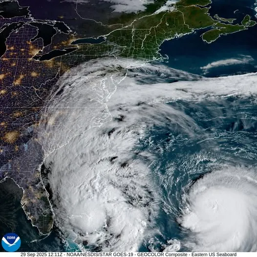
Satellite imagery on Monday morning revealed a striking display of Tropical Storm Imelda’s expansive cloud cover, stretching nearly 1,000 miles from its center into Central Pennsylvania, according to the National Weather Service in State College. The storm’s broad footprint is bringing overcast skies and moisture far inland, despite remaining offshore.
Meanwhile, Hurricane Humberto continues to churn in the Atlantic, maintaining its strength and distance from the U.S. coast. While neither system is expected to make landfall, their combined influence is contributing to unsettled weather across the region. Forecasters are monitoring both storms closely as the 2025 hurricane season enters its final stretch.
...
Sep 29, 2025 at 10:55 AM EDT
The deadliest and most destructive hurricanes in U.S. history

...
From the Gulf Coast to the Eastern Seaboard, hurricanes have left a lasting mark on American communities. A recent roundup from Morgan & Morgan highlights the most devastating storms to strike the U.S., measured by loss of life and property damage.
Topping the list is Hurricane Maria (2017), which ravaged Puerto Rico with sustained winds over 175 mph, claiming more than 3,000 lives and causing nearly $100 billion in damage. Hurricane Katrina (2005) follows closely, remembered for its catastrophic flooding in New Orleans and a death toll exceeding 1,800.
The 1900 Galveston hurricane remains the deadliest in U.S. history, killing over 8,000 people. More recent storms, such as Hurricane Harvey (2017) and Hurricane Irma (2017), caused tens of billions of dollars in damage and displaced thousands across Texas and Florida.
Other notable entries include Hurricane Andrew (1992), which destroyed over 130,000 homes in South Florida, and Hurricane Michael (2018), a Category 5 storm that slammed the Florida Panhandle. Historic storms, such as the 1938 New England hurricane and the 1926 Miami hurricane, also rank among the most destructive.
These events highlight the importance of hurricane preparedness and the ongoing risks associated with tropical cyclones. Storm surge, inland flooding, high winds, rip currents, and tornadoes remain the primary hazards, often impacting areas far beyond the coast.
Sep 29, 2025 at 10:43 AM EDT
Understanding hurricane hazards and how to stay safe
Hurricanes rank among the most destructive forces in nature, forming regularly during the June to November storm season across the Atlantic, Caribbean, and Gulf of Mexico. On average, 14 tropical storms develop annually in the Atlantic basin, with about half intensifying into hurricanes. The Central Pacific sees fewer storms, but Guam and the surrounding islands face year-round typhoon threats, peaking from August to September.
While hurricanes are known for their powerful winds, the most significant dangers often come from storm surge and flooding. Storm surge—an abnormal rise in sea level driven by hurricane winds—is the leading cause of hurricane-related deaths in the U.S. It can push water miles inland, especially near bays and rivers. Torrential rains can also trigger widespread flooding far from the coast, lasting days after the storm passes.
Wind damage is another significant hazard, capable of tearing apart buildings and turning debris into dangerous projectiles. Tornadoes may form within outer rain bands, and high surf can erode beaches and damage coastal infrastructure—even when the storm is hundreds of miles offshore.
Sep 29, 2025 at 10:30 AM EDT
Hurricane safety and employer responsibilities during storm season
Hurricanes are powerful tropical cyclones with sustained winds of at least 74 mph, capable of causing widespread destruction across coastal and inland communities. The Atlantic hurricane season runs from June through November, peaking between August and October. The Eastern Pacific hurricane season begins in mid-May and ends in November.
To help mitigate risks, OSHA and NOAA have partnered on a public education initiative focused on hurricane preparedness and response. Resources include guidance on storm warnings, evacuation planning, and emergency supply kits, as well as OSHA’s Hurricane eMatrix—a tool that outlines safety protocols based on specific recovery tasks.
Employers play a crucial role in protecting workers before, during, and after hurricanes. They are legally obligated to provide safe working conditions and protect employees from known hazards associated with storm recovery operations. Businesses are encouraged to review OSHA’s guidelines to ensure compliance and safeguard their workforce during severe weather events.
Sep 29, 2025 at 10:17 AM EDT
Imelda strengthens as Bermuda watches storm’s path
Tropical Storm Imelda is expected to intensify into a hurricane by Tuesday, according to the National Hurricane Center. As of Monday morning, the storm was impacting the northwestern Bahamas with heavy rain and gusty winds.
Forecasters say Imelda could pose a threat to Bermuda later this week, following the passage of Hurricane Humberto to the island’s north. While Imelda is not projected to make landfall in the U.S., its evolving track and strengthening winds remain under close watch.
Sep 29, 2025 at 10:05 AM EDT
How hurricanes form and intensify: A look at tropical cyclones
Hurricanes, typhoons, and tropical cyclones are all names for the same weather phenomenon: a rotating, low-pressure system with organized thunderstorm activity that forms over warm tropical or subtropical waters. These systems draw energy from the ocean's heat and moisture, fueling their development and intensity.
Meteorologists classify tropical cyclones by wind speed:
- Tropical depression: winds less than 39 mph
- Tropical storm: winds between 39–73 mph
- Hurricane: winds of 74 mph or higher
- Major hurricane: winds of 111 mph or more
As a storm strengthens, it becomes more "organized," meaning its thunderstorms begin to wrap around a central point, forming distinct bands. This structure signals the development of a closed circulation—winds rotating continuously around a center. In the Northern Hemisphere, this rotation is counterclockwise; in the Southern Hemisphere, it's clockwise.
The hallmark of a mature hurricane is its eye—a calm, clear center surrounded by the eyewall, where the most intense winds occur. Satellite imagery often reveals this structure as storms intensify, as seen in past hurricanes like Ian and Michael.
These powerful systems can produce destructive winds, torrential rain, and coastal flooding. Their formation depends on a combination of warm ocean temperatures, moist air, and minimal wind shear. When these conditions align, tropical cyclones can rapidly escalate into major hurricanes capable of widespread damage.
Sep 29, 2025 at 09:59 AM EDT
Humberto and Imelda to stir coastal hazards along North Carolina
Hurricane Humberto and Tropical Storm Imelda are expected to remain offshore this week, but both systems will bring hazardous conditions to the North Carolina coast. As of Monday morning, Humberto was a Category 4 hurricane with sustained winds of 145 mph, located roughly 365 miles south-southwest of Bermuda. Imelda, which strengthened into a tropical storm Sunday, was positioned about 265 miles east-southeast of Cape Canaveral and moving north at 9 mph.
Neither storm is forecast to make landfall in the U.S., but the National Weather Service has issued multiple advisories for coastal regions. High surf, dangerous rip currents, and moderate coastal flooding are expected from Carteret County to New Hanover County through the end of the week. Breaking waves could reach up to 12 feet in some areas, and inundation of 1–3 feet is possible near shorelines and tidal waterways.
Rainfall across North Carolina is likely early in the week, though totals are trending lower as both storms shift eastward. Imelda may strengthen into a hurricane before turning away from the coast on Tuesday. Humberto is expected to curve northeast by midweek, continuing to generate swells along the East Coast. The Atlantic hurricane season runs through November 30.
Sep 29, 2025 at 09:51 AM EDT
How to stay safe during hurricane season
Hurricanes are powerful systems that can bring destructive winds, flooding, and storm surge far beyond coastal areas. With months left in the 2025 season, experts urge families to prepare now to stay safe.
Before a storm hits, make evacuation and shelter plans, gather emergency supplies, and monitor official alerts. A Go-Kit should include three days of essentials, while a Stay-at-Home Kit should cover two weeks. Secure outdoor items, protect windows, and clear gutters to reduce damage.
If evacuation is ordered, leave immediately and follow designated routes. If sheltering in place, stay in a windowless interior room on the lowest safe level. Move to higher ground if flooding begins.
After the storm, wait for local officials to declare it safe to return. Avoid floodwaters and downed power lines, and use generators only in well-ventilated areas. Clean up with protective gear and stay alert to health risks.
The Red Cross offers shelter, supplies, and support during hurricanes. For more resources, including multilingual safety checklists and emergency apps, visit their website.
Sep 29, 2025 at 09:40 AM EDT
Imelda’s Name: How are storms named?
Before the 1950s, tropical storms and hurricanes were identified by the year and sequence in which they formed, according to the National Oceanic and Atmospheric Administration. However, as forecasting and communication improved, experts recognized that assigning short, memorable names helped reduce confusion—especially when multiple storms were active simultaneously.
The U.S. began using female names for storms in 1953, later expanding to include male names in the Northern Pacific by 1978 and the Atlantic basin by 1979. Today, storm naming follows a strict protocol set by the World Meteorological Organization, not the National Hurricane Center.
Atlantic storm names rotate on a six-year cycle, with names retired if a storm is particularly deadly or destructive. If a season exceeds 21 named storms, a backup list is used. For full details on current and retired names, the National Weather Service maintains an updated directory.
Sep 29, 2025 at 09:29 AM EDT
What is the Fujiwhara effect?
The Fujiwhara effect is a rare but impactful meteorological phenomenon where two nearby rotating weather systems—such as hurricanes or tropical storms—begin to orbit around a shared center due to their mutual influence. Named after Japanese meteorologist Sakuhei Fujiwhara, this interaction can lead to several outcomes: The storms may spin around each other, merge into a single larger system, or one may absorb the other entirely.
For the effect to occur, the systems typically need to be within approximately 900 miles of each other. As they draw closer, their circulations interact like dancers in a waltz, with the stronger storm often dominating the weaker one. The final result depends on each system’s size, intensity, and the surrounding atmospheric conditions, including wind shear and pressure patterns.
This dynamic adds complexity to forecasting, as it can dramatically shift storm tracks and intensities. While more common in the West Pacific due to its higher storm frequency, the Fujiwhara effect can also influence Atlantic systems, especially during active hurricane seasons.
Sep 29, 2025 at 09:23 AM EDT
What you need to know: Imelda and Humberto stir Atlantic hazards
Tropical Storm Imelda and Hurricane Humberto are both active in the Atlantic, creating hazardous conditions across the Caribbean and the U.S. East Coast. Imelda was delivering heavy rain to the region early Monday, just hours after being named. Humberto, a powerful Category 4 hurricane, is farther offshore but is expected to generate life-threatening surf and rip currents along the U.S. coastline starting today.
The two storms are close enough to interact through the Fujiwhara effect, a phenomenon where nearby cyclones influence each other’s movement. Forecast models suggest this interaction will steer Imelda away from the U.S., reducing the risk of a direct landfall. Tropical storm warnings remain in effect for parts of the Bahamas, while Bermuda is under a tropical storm watch. Although Florida’s watch was lifted Sunday, forecasters warn that heavy rain could still reach the Carolinas by midweek. Flash flooding remains a concern in vulnerable areas.
Sep 29, 2025 at 09:19 AM EDT
Hurricane Humberto: Will it cross paths with Imelda?
Tropical Storm Imelda is no longer expected to make landfall along the U.S. Southeast coast, thanks to the influence of nearby Hurricane Humberto. Forecasters say the stronger storm’s circulation is steering Imelda eastward into the Atlantic, a dynamic known as the Fujiwhara effect—when two cyclones interact and alter each other’s paths.
Instead of a direct strike, the U.S. East Coast will face indirect impacts, including rough surf, rip currents and scattered rainfall. Humberto, currently a Category 4 hurricane west of Bermuda, is forecast to pass north of the island early this week.
Imelda, which has already brought flooding to parts of the Bahamas, is expected to strengthen into a hurricane before tracking toward Bermuda later in the week. The island could face back-to-back tropical systems in a matter of days.
Sep 29, 2025 at 09:13 AM EDT
NHC issues marine warnings as Humberto and Imelda intensify
The National Hurricane Center is actively monitoring Hurricane Humberto and Tropical Storm Imelda, both of which are producing hazardous conditions across the Atlantic. As of Monday morning, marine warnings are in effect for the Atlantic and the southwestern North Atlantic.
Humberto, now slightly stronger, is packing sustained winds of 145 mph and is located northwest of Bermuda. The storm is expected to generate dangerous surf along Bermuda and much of the U.S. East Coast this week. Tropical storm conditions are possible in Bermuda by Tuesday.
Meanwhile, Imelda continues to move northward through the Bahamas with sustained winds of 50 mph. Tropical storm conditions are ongoing in the northwestern Bahamas, and the system is forecast to strengthen further as it tracks offshore near the southeastern U.S.
No active disturbances are reported in the Eastern or Central Pacific, but the Atlantic basin remains active as the 2025 hurricane season progresses. The NHC continues to provide updated forecasts, wind probabilities, and rainfall potential graphics to help communities prepare.
Sep 29, 2025 at 09:09 AM EDT
Hurricane Humberto 2025 Tracking: Where is the storm headed?
Hurricane Humberto is tracking east-northeast over the Atlantic and is expected to remain well offshore, avoiding a direct strike on the U.S. mainland. The storm, currently south of Bermuda, is forecast to curve eastward late Tuesday into Wednesday, keeping its center hundreds of miles from the coast.
Despite its offshore path, Humberto’s wide circulation will continue to generate hazardous surf, rip currents and beach erosion from Florida through the Mid-Atlantic. Bermuda may see tropical-storm-force winds as the hurricane passes west and north of the island midweek.
Parts of the Bahamas could also receive rainfall from Humberto’s outer bands. Forecasters expect the storm to gradually weaken over the next 24 hours due to cooler waters and increasing wind shear.
Sep 29, 2025 at 09:04 AM EDT
What category is Hurricane Humberto?
Hurricane Humberto remains a major storm Monday morning, maintaining Category 4 intensity with sustained winds near 130 mph and a central pressure of 933 mb, according to the National Hurricane Center. The system is located roughly 375 miles south-southwest of Bermuda and is moving northwest at 14 mph.
Forecasters expect Humberto to shift northward before turning east-northeast by midweek. A Tropical Storm Watch is in effect for Bermuda, where gusty winds and heavy surf are likely through Tuesday.
Swells generated by Humberto are already impacting the northern Leeward Islands, Virgin Islands, Puerto Rico and Bermuda, with hazardous surf expected to reach the U.S. East Coast starting Monday.
Sep 29, 2025 at 08:58 AM EDT
Wrightsville Beach Urges Caution Ahead of Imelda’s Coastal Impacts
Officials in Wrightsville Beach are advising residents and visitors to stay alert as Tropical Storm Imelda approaches the Carolina coast, per ABC11. The system is expected to bring gusty winds, heavy rainfall and localized flooding on Monday before shifting eastward into the Atlantic.
While the storm’s center is forecast to remain offshore, its wide reach could still disrupt coastal conditions. Some beachgoers said they cut their trips short to avoid worsening weather, while others noted the surf was already showing signs of turbulence.
Local authorities continue to monitor forecasts and are urging the public to prepare for rapidly changing conditions.
Sep 29, 2025 at 08:52 AM EDT
Where is Imelda now?
Tropical Storm Imelda was impacting the central and northwestern Bahamas early Monday with strong winds and heavy rainfall, according to the National Hurricane Center. As of 5 a.m. EDT, the storm’s center was located roughly 60 miles south of Great Abaco Island and about 295 miles southeast of Cape Canaveral, Florida.
Maximum sustained winds were measured at 45 mph, with tropical storm-force gusts extending outward from the center. Forecasters warned of flash flooding and coastal inundation across the Bahamas as the system continues to intensify. Imelda is expected to strengthen into a hurricane by Tuesday as it tracks northward along the U.S. Southeast coast.
Sep 29, 2025 at 08:47 AM EDT
When is Imelda expected to hit?
Tropical Storm Imelda is forecast to intensify into a Category 1 hurricane late Monday into early Tuesday as it moves through the Bahamas and parallels Florida’s Atlantic coast. The system, named Sunday, is tracking northward but is expected to veer sharply east later this week, potentially approaching Bermuda by Thursday night.
Even before reaching hurricane strength, Imelda has triggered severe flooding across parts of the Caribbean. Heavy rainfall in Puerto Rico and the Dominican Republic led to two fatalities on Friday, while Grand Bahama saw airport closures and mandatory evacuations over the weekend. Forecasts from the National Hurricane Center project up to 12 inches of rain in parts of Cuba and the Bahamas through Tuesday, with storm surge reaching up to 3 feet in low-lying coastal zones.
Imelda’s moisture is also expected to reach the southeastern United States, with the Carolinas facing up to 6.6 inches of rain and localized flooding by midweek. Coastal areas may see water levels rise 2 feet above normal at high tide.
Sep 29, 2025 at 08:42 AM EDT
Tropical Storm Imelda’s path dramatically shifts

Tropical Storm Imelda is expected to move across the northwestern Bahamas on Monday, followed by a sharp turn to the east-northeast on Tuesday, moving away from the southeastern U.S. by midweek, according to the National Hurricane Center (NHC).
Previous spaghetti models—computer simulations that illustrate potential storm paths using meteorological data—suggested Imelda could potentially track toward the U.S. Southeast Coast.
The NHC has cautioned that swells and high surf from Imelda and nearby Hurricane Humberto are forecast to create hazardous marine conditions and rip currents along Florida’s east coast and the Georgia shoreline through Monday. These impacts are expected to extend northward, affecting much of the U.S. East Coast early this week.
Read the full story by Joe Edwards on Newsweek.
View 0 Comments
Submit Correction
View Editorial & AI Guidelines